Category:Haggate
Jump to navigation
Jump to search
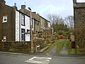
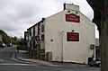
English: Haggate is a small village within the parish of Briercliffe, situated three miles north of Burnley, Lancashire. The village is mostly built around a small crossroads, with routes towards Burnley, Nelson and Todmorden. The first buildings in the village date from the 16th century, when the Hare and Hounds public house, which still stands to this day, was built. The village was first officially documented in the 17th century. The origins of the name Haggate are unclear, although it is thought that it could mean, "the path by the hawthorn trees". The village itself is situated at the top of a hill, 800 feet above sea level. The buildings in the village are predominantly stone-built.
village in United Kingdom  | |||||
| Upload media | |||||
| Instance of | |||||
|---|---|---|---|---|---|
| Location | Briercliffe, Burnley, Lancashire, North West England, England | ||||
 | |||||
Media in category "Haggate"
The following 13 files are in this category, out of 13 total.
-
 Acre Street, Haggate - geograph.org.uk - 1593115.jpg 640 × 480; 81 KB
-
 Burnley Road, Haggate - geograph.org.uk - 1593118.jpg 640 × 480; 57 KB
-
 Cockden Bridge - geograph.org.uk - 772096.jpg 640 × 480; 172 KB
-
 Haggate HareandHounds.jpg 610 × 404; 53 KB
-

-
 Hare and Hounds, 1 Halifax Road, Burnley - geograph.org.uk - 763807.jpg 640 × 480; 166 KB
-
 The 'Sun Inn', Haggate, Lancashire - geograph.org.uk - 555236.jpg 640 × 427; 76 KB
-
 The Sun Inn, 1 Burnley Road, Burnley - geograph.org.uk - 763810.jpg 640 × 480; 218 KB
-
 Baptist Church, Haggate, Lancashire - geograph.org.uk - 555254.jpg 640 × 427; 94 KB
-
 Former Jehovah Jireh Chapel - geograph.org.uk - 763817.jpg 480 × 640; 175 KB
-
 Former Jehovah Jireh Chapel - geograph.org.uk - 763820.jpg 620 × 464; 137 KB
-
 Reading Room, Haggate, Lancashire - geograph.org.uk - 555249.jpg 640 × 427; 95 KB
-
 They beat us to it - geograph.org.uk - 421415.jpg 640 × 426; 138 KB


