Category:Gymnasium am Ostring
Jump to navigation
Jump to search
| Object location | | View all coordinates using: OpenStreetMap |
|---|
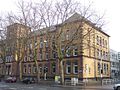
school in Bochum, Germany  | |||||
| Upload media | |||||
| Instance of | |||||
|---|---|---|---|---|---|
| Location | Bochum, Arnsberg Government Region, North Rhine-Westphalia, Germany | ||||
| Street address |
| ||||
| Inception |
| ||||
| Dissolved, abolished or demolished date |
| ||||
 | |||||
Media in category "Gymnasium am Ostring"
The following 7 files are in this category, out of 7 total.
-
 Bochum - Ostring - Gymnasium am Ostring 01 ies.jpg 5,616 × 3,744; 8.86 MB
-
 Bochum - Ostring - Gymnasium am Ostring 02 ies.jpg 3,744 × 5,616; 7.69 MB
-
 Bochum - Ostring - Gymnasium am Ostring 03 ies.jpg 5,616 × 3,744; 11.72 MB
-
 Bochum - Ostring - Gymnasium am Ostring 04 ies.jpg 5,616 × 3,744; 9 MB
-
 Bochum Gymnasium am Ostring.jpg 1,600 × 1,198; 482 KB
-
 Bochum-Ostring27-1-Asio.JPG 3,412 × 2,274; 1.42 MB
-
 Gymnasium am ostring bochum 1912.jpg 512 × 384; 38 KB


