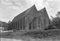
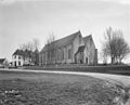
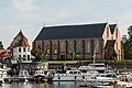
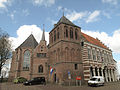
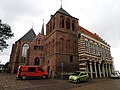
Category:Grote of Sint-Nicolaaskerk (Vollenhove)
Jump to navigation
Jump to search
| Object location | | View all coordinates using: OpenStreetMap |
|---|
 | |||||
| Upload media | |||||
| Instance of |
| ||||
|---|---|---|---|---|---|
| Location | Vollenhove, Vollenhove | ||||
| Located on street |
| ||||
| Heritage designation |
| ||||
 | |||||
Nederlands: Nicolaas of Grote Kerk - anno 14e eeuw
Kerk
|
This is a category about rijksmonument number 10555
|
Toren
|
This is a category about rijksmonument number 10554
|
| Address |
|
Subcategories
This category has the following 2 subcategories, out of 2 total.
Media in category "Grote of Sint-Nicolaaskerk (Vollenhove)"
The following 93 files are in this category, out of 93 total.
-
 20140515 Grote of Sint Nicolaaskerk Vollenhove.jpg 4,613 × 3,460; 2.73 MB
-
 20140515 Zicht op Vollenhove vanaf de dijk langs Vollenhoverkanaal.jpg 4,896 × 3,672; 2.76 MB
-
 20140515 Zicht op Vollenhove.jpg 4,896 × 1,529; 1.48 MB
-
 20140515 Zicht2 op Vollenhove.jpg 4,896 × 3,672; 3.15 MB
-
 Achterzijde grote kerk, Vollenhove.JPG 4,032 × 3,024; 2.19 MB
-
 De grote kerk van Vollenhove.jpg 2,449 × 1,633; 2.09 MB
-
 Exterieur west-zijde - Vollenhove - 20244976 - RCE.jpg 951 × 1,200; 254 KB
-
 Exterieur zijbeuk zuid-zijde - Vollenhove - 20244975 - RCE.jpg 956 × 1,200; 281 KB
-
 Exterieur zuid-zijde - Vollenhove - 20244972 - RCE.jpg 1,200 × 952; 349 KB
-
 Exterieur zuid-zijde naar het oosten - Vollenhove - 20244973 - RCE.jpg 959 × 1,200; 352 KB
-
 Flevoland DSCN5852 WCm.jpg 3,412 × 2,430; 2.27 MB
-
 Gedeelte oostgevel en toren - Vollenhove - 20245031 - RCE.jpg 935 × 1,200; 359 KB
-
 Gedeelte zuidgevel - Vollenhove - 20245027 - RCE.jpg 961 × 1,200; 382 KB
-
 Grafsteen in 't Koor - Vollenhove - 20244987 - RCE.jpg 954 × 1,200; 278 KB
-
 Grote Kerk en stadhuis tekening - Vollenhove - 20244988 - RCE.jpg 1,200 × 929; 361 KB
-
 Grote kerk Vollenhove.jpg 300 × 202; 14 KB
-

-
 Grote of Sint Nicolaaskerk Vollenhove.jpg 2,736 × 3,648; 1.14 MB
-
 Kerk aan het Kerkplein - Vollenhove - 20244964 - RCE.jpg 809 × 1,200; 181 KB
-
 Kerk en Kleine Toren - Vollenhove - 20244966 - RCE.jpg 810 × 1,200; 182 KB
-
 Kerk en raadhuis - Vollenhove - 20244960 - RCE.jpg 1,200 × 815; 247 KB
-
 Kerk vanuit het noord-oosten - Vollenhove - 20244961 - RCE.jpg 1,200 × 822; 256 KB
-
 Kerk vanuit het oosten - Vollenhove - 20244962 - RCE.jpg 1,200 × 834; 269 KB
-
 Kerk, exterieur - Vollenhove - 20244965 - RCE.jpg 1,200 × 800; 142 KB
-
 Kerk, exterieur - Vollenhove - 20244968 - RCE.jpg 1,200 × 808; 143 KB
-
 Kerk, uitwendig - Vollenhove - 20244967 - RCE.jpg 1,200 × 805; 133 KB
-
 Kerkplein1 kerk Vollenhove.jpg 1,824 × 1,368; 590 KB
-
 Kerkplein1 kerk2 Vollenhove.jpg 1,824 × 1,368; 562 KB
-
 Kerkplein1 kerk3 Vollenhove.jpg 1,742 × 1,306; 290 KB
-
 Noord-zijde exterieur - Vollenhove - 20244978 - RCE.jpg 1,200 × 946; 256 KB
-
 Oost-zijde exterieur - Vollenhove - 20244969 - RCE.jpg 1,200 × 951; 236 KB
-
 Oost-zijde exterieur - Vollenhove - 20244970 - RCE.jpg 1,200 × 946; 237 KB
-
 Oostgevel - Vollenhove - 20245029 - RCE.jpg 1,200 × 960; 279 KB
-
 Oostgevel - Vollenhove - 20245030 - RCE.jpg 953 × 1,200; 287 KB
-
 Oostzijde met toren - Vollenhove - 20245028 - RCE.jpg 1,200 × 936; 213 KB
-
 Orgel - Vollenhove - 20244983 - RCE.jpg 953 × 1,200; 214 KB
-
 Oude Haven, op de achtergrond Grote- of Bovenkerk. - Vollenhove - 20245132 - RCE.jpg 1,181 × 1,200; 312 KB
-
 Oude Vissershaven, bij de Grote Kerk, Vollenhove.JPG 4,032 × 2,630; 2.04 MB
-
 Overzicht - Vollenhove - 20245021 - RCE.jpg 1,200 × 954; 237 KB
-
 Overzicht - Vollenhove - 20245022 - RCE.jpg 1,200 × 955; 220 KB
-
 Overzicht - Vollenhove - 20245023 - RCE.jpg 1,200 × 967; 253 KB
-

-
 Overzicht Haven - Vollenhove - 20244865 - RCE.jpg 1,181 × 1,200; 332 KB
-
 Overzicht Haven - Vollenhove - 20244866 - RCE.jpg 1,200 × 1,200; 319 KB
-
 Overzicht Markt - Vollenhove - 20244894 - RCE.jpg 1,197 × 1,200; 358 KB
-
 Overzicht Markt - Vollenhove - 20244895 - RCE.jpg 1,192 × 1,200; 313 KB
-

-

-

-

-
 Overzicht toren en gevel - Vollenhove - 20328300 - RCE.jpg 946 × 1,200; 236 KB
-

-
 Overzicht voorgevel raadhuis en kerktoren - Vollenhove - 20344910 - RCE.jpg 950 × 1,200; 256 KB
-
 Raadhuis en toren - Vollenhove - 20244925 - RCE.jpg 1,200 × 897; 233 KB
-
 Raadhuis met voormalige kerktoren - Vollenhove - 20244926 - RCE.jpg 1,200 × 1,155; 346 KB
-
 Sacristie noordzijde - Vollenhove - 20244990 - RCE.jpg 951 × 1,200; 294 KB
-
 Sacristie oostzijde - Vollenhove - 20244998 - RCE.jpg 951 × 1,200; 357 KB
-
 Sacristie raam zuidzijde - Vollenhove - 20244994 - RCE.jpg 960 × 1,200; 402 KB
-
 Sacristie top oostgevel - Vollenhove - 20244993 - RCE.jpg 993 × 1,200; 341 KB
-
 Sacristie zuidzijde - Vollenhove - 20245001 - RCE.jpg 965 × 1,200; 336 KB
-
 Toren - Vollenhove - 20244989 - RCE.jpg 775 × 1,200; 227 KB
-
 Toren van de grote kerk, Vollenhove.JPG 4,032 × 3,024; 2.24 MB
-
 Toren zuid-zijde - Vollenhove - 20244971 - RCE.jpg 960 × 1,200; 280 KB
-
 Vollenhove - grote kerk-10.jpg 3,888 × 2,592; 5.22 MB
-
 Vollenhove - grote kerk-11.jpg 2,592 × 3,888; 4.51 MB
-
 Vollenhove - grote kerk-12.jpg 3,888 × 2,592; 3.71 MB
-
 Vollenhove - grote kerk-7.jpg 3,888 × 2,592; 3.52 MB
-
 Vollenhove - grote kerk-8.jpg 3,888 × 2,592; 4.15 MB
-
 Vollenhove - grote kerk-9.jpg 2,592 × 3,888; 4.47 MB
-
 Vollenhove 004.JPG 3,264 × 2,448; 2.32 MB
-
 Vollenhove 046.JPG 3,264 × 2,448; 1.97 MB
-
 Vollenhove 051.JPG 3,264 × 2,448; 2.31 MB
-
 Vollenhove harbour.jpg 3,008 × 2,000; 1.07 MB
-
 Vollenhove Netherlands Grote-of-Sint-Nicolaaskerk-01.jpg 5,038 × 3,359; 9.92 MB
-
-
 Vollenhove, de Haven met de Grote-of Sint Nicolaaskerk RM10555 IMG 2849 2018-04-20 15.31.jpg 5,130 × 2,952; 9.46 MB
-
 Vollenhove, Grote- of Sint Nicolaaskerk, 06.JPG 2,405 × 1,604; 2.11 MB
-
 Vollenhove, Grote- of Sint Nicolaaskerk, 07.JPG 1,711 × 2,567; 2.1 MB
-
 Vollenhove, Grote- of Sint Nicolaaskerk, 08.JPG 1,728 × 2,592; 3.13 MB
-
 Vollenhove, Grote- of Sint Nicolaaskerk, 10.JPG 1,728 × 2,592; 3.51 MB
-
 Vollenhove, Grote- of Sint Nicolaaskerk, met spiegeling in water 02.JPG 1,527 × 2,291; 1.74 MB
-
 Vollenhove, Grote- of Sint Nicolaaskerk, met spiegeling in water 03.JPG 2,321 × 1,547; 1.79 MB
-
 Vollenhove, Grote- of Sint Nicolaaskerk, met spiegeling in water 04.JPG 1,728 × 2,592; 2.79 MB
-
 Vollenhove, Kerk, toren, stadhuis-DSCN0187WLM.jpg 4,608 × 3,456; 8.21 MB
-
 Vollenhoven grootn karke.jpg 300 × 400; 99 KB
-
 West-gevel ingang - Vollenhove - 20244977 - RCE.jpg 954 × 1,200; 338 KB
-
 Westgevel - Vollenhove - 20245024 - RCE.jpg 1,200 × 950; 426 KB
-
 Westgevel - Vollenhove - 20245025 - RCE.jpg 952 × 1,200; 365 KB
-
 Zicht op Vollenhove.jpg 3,648 × 1,482; 389 KB
-
 Zuid-gevel naar het westen met zijbeuk - Vollenhove - 20244974 - RCE.jpg 948 × 1,200; 310 KB
-
 Zuid-oost gevel - Vollenhove - 20245026 - RCE.jpg 1,200 × 959; 410 KB
-
 Òverzicht zuidwestgevel met jachthaven op de voorgrond - Vollenhove - 20350512 - RCE.jpg 1,173 × 1,200; 252 KB
-
 Òverzicht zuidwestgevel met jachthaven op de voorgrond - Vollenhove - 20350513 - RCE.jpg 1,183 × 1,200; 316 KB


_De_bijbehorende_toren_(midden)_en_de_stadsbodewoning_(Rechts),_Vollenhove.jpg)


