Category:Groenestraat 146, Kampen
Jump to navigation
Jump to search
| Object location | | View all coordinates using: OpenStreetMap |
|---|
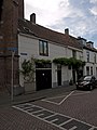
building in Kampen, Netherlands  | |||||
| Upload media | |||||
| Instance of | |||||
|---|---|---|---|---|---|
| Location | Kampen, Overijssel, Netherlands | ||||
| Heritage designation |
| ||||
 | |||||
|
This is a category about rijksmonument number 23036
|
| Address |
|
Media in category "Groenestraat 146, Kampen"
The following 5 files are in this category, out of 5 total.
-
 Kampen - Groenestraat - 2016 -002.jpg 4,770 × 3,178; 14 MB
-
 Kampen - Groenestraat 148.jpg 1,944 × 2,592; 1.16 MB
-
 Kampen 9-2011 (8).JPG 2,592 × 1,944; 995 KB
-
 Kampen Groenestraat146.jpg 2,736 × 3,648; 5.55 MB
-
 Voorgevels - Kampen - 20123161 - RCE.jpg 1,189 × 1,200; 284 KB


.JPG)
