Category:Granary in Trzebieszowice
Jump to navigation
Jump to search
| Object location | | View all coordinates using: OpenStreetMap |
|---|
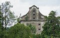
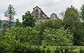
hambar in Trzebieszowice, Lower Silesian Voivodeship, Poland  | |||||
| Upload media | |||||
| Instance of | |||||
|---|---|---|---|---|---|
| Location | Trzebieszowice, Gmina Lądek-Zdrój, Kłodzko County, Lower Silesian Voivodeship, Poland | ||||
| Heritage designation |
| ||||
| Inception |
| ||||
 | |||||
Media in category "Granary in Trzebieszowice"
The following 4 files are in this category, out of 4 total.
-
 2015 Spichrz w Trzebieszowicach 01.JPG 4,270 × 2,712; 9.55 MB
-
 2015 Spichrz w Trzebieszowicach 02.JPG 3,821 × 2,800; 8.07 MB
-
 2015 Spichrz w Trzebieszowicach 03.JPG 4,260 × 2,742; 9.9 MB
-
 Spichlerz z 1733 roku.JPG 3,853 × 2,355; 1.6 MB


