Category:Grainger Market
Jump to navigation
Jump to search
| Object location | | View all coordinates using: OpenStreetMap |
|---|
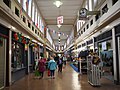
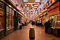
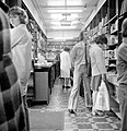
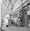
English: Grainger Market is a covered market that opened in 1835 in the Grainger Town area of central Newcastle upon Tyne. Laid out as a SSW-NNE rectangle, it is bordered by Clayton Street along its west side, Grainger Street on the east side, Nelson Street along the north end, and Nun Street on the south end, with entrances through the buildings along each of the four streets.
Grade I listed building in the United Kingdom  | |||||
| Upload media | |||||
| Instance of | |||||
|---|---|---|---|---|---|
| Location | Newcastle upon Tyne, Tyne and Wear, North East England, England | ||||
| Heritage designation |
| ||||
| Inception |
| ||||
| official website | |||||
 | |||||
Subcategories
This category has the following 4 subcategories, out of 4 total.
Media in category "Grainger Market"
The following 57 files are in this category, out of 57 total.
-

-
 A. Kettlewell - Grainger Market - geograph.org.uk - 1601652.jpg 640 × 480; 96 KB
-
 Aerial view of Newcastle City Centre, 1977 (26109496645).jpg 1,000 × 788; 270 KB
-
 Aerial view of Newcastle upon Tyne, 1977 (25202030394).jpg 1,017 × 802; 262 KB
-
 Alley No 2 in the Grainger Market September 2022.jpg 4,608 × 3,456; 5.55 MB
-
 Angel and Devils (6466323543).jpg 4,000 × 4,040; 4.07 MB
-
 Construction, Newcastle city centre (6520989579).jpg 4,000 × 4,070; 4.72 MB
-
 Crockery and S. Murray, Grainger Market (6521096287).jpg 4,000 × 4,170; 4.79 MB
-
 From the Castle Keep to St James' Park, 1977 (25351820433).jpg 1,037 × 818; 282 KB
-
 G Leslie Oliver and Co - Grainger Market - geograph.org.uk - 1601656.jpg 640 × 480; 102 KB
-

-
 Grainger Market (geograph 3363178).jpg 3,072 × 2,304; 2.45 MB
-
 Grainger Market - geograph.org.uk - 1769408.jpg 859 × 1,024; 330 KB
-
 Grainger Market - geograph.org.uk - 668142.jpg 427 × 640; 70 KB
-
 Grainger Market - geograph.org.uk - 697178.jpg 640 × 480; 102 KB
-
 Grainger Market Newcastle Upon Tyne.jpg 4,000 × 2,667; 10.86 MB
-
 Grainger Market, Newcastle upon Tyne (21679783973).jpg 640 × 454; 120 KB
-
 Grainger Market, Newcastle upon Tyne (22112798250).jpg 607 × 480; 113 KB
-
 Grainger Market, Newcastle upon Tyne (22113108538).jpg 640 × 444; 105 KB
-
 Grainger Market, Newcastle upon Tyne (22113108598).jpg 480 × 538; 92 KB
-
 Grainger Market, Newcastle upon Tyne (22113108868).jpg 625 × 480; 115 KB
-
 Grainger Market, Newcastle upon Tyne (22113993049).jpg 480 × 582; 116 KB
-
 Grainger Market, Newcastle upon Tyne (22274792186).jpg 640 × 459; 128 KB
-
 Grainger Market, Newcastle upon Tyne (22287923862).jpg 480 × 605; 97 KB
-
 Grainger Market, Newcastle upon Tyne (22311377661).jpg 602 × 480; 101 KB
-
 Grainger Market, Newcastle upon Tyne, 11 September 2004.jpg 819 × 614; 121 KB
-
 Grainger Market, Newcastle upon Tyne, 22 May 2009.jpg 2,186 × 1,628; 735 KB
-
 Grainger Market, Newcastle upon Tyne, 27 July 2011 (1).jpg 5,184 × 3,456; 3.51 MB
-
 Grainger Market, Newcastle upon Tyne, 27 July 2011 (2).jpg 5,184 × 3,456; 3.5 MB
-
 Grainger Market, Newcastle upon Tyne, 27 July 2011 (3).jpg 5,184 × 3,456; 5.15 MB
-
 Grainger Market, Newcastle upon Tyne, 6 January 2012.jpg 4,272 × 2,848; 4.11 MB
-

-
 Grainger Market, Newcastle.jpg 4,000 × 2,672; 5.05 MB
-
 Grainger Market, Silver Ukulele Players Christmas Concert (geograph 3260375).jpg 3,648 × 2,736; 1.16 MB
-
 Grey's Monument and surrounding streets, 1978 (25665792813).jpg 996 × 788; 564 KB
-
 Harry Dunn butchers, Grainger Market (6466515573).jpg 4,000 × 4,173; 5.39 MB
-
 Hector Hall farm produce, Grainger Market (6520992099).jpg 4,000 × 4,216; 6.4 MB
-
 Horse and cart, Newcastle upon Tyne (6521109889).jpg 4,000 × 4,212; 6.17 MB
-
 Inside the Grainger Market, Newcastle upon Tyne (geograph 3068962).jpg 1,024 × 768; 631 KB
-
 Jimmy Forsyth 2007 (22375639082).jpg 480 × 635; 167 KB
-
 Katy's Hat Shop, Grainger Market (6520989801).jpg 768 × 804; 288 KB
-

-
 Looking west across Newcastle City Centre, 1977 (25249220043).jpg 1,040 × 816; 274 KB
-
 Marks and Spencer, Newcastle Grainger Market (6466322281).jpg 4,000 × 4,261; 7.18 MB
-
 Newcastle Central Station and surrounding area, 1977 (25396574653).jpg 1,019 × 804; 268 KB
-
 Newcastle City Centre from the air (26003437035).jpg 1,017 × 803; 262 KB
-

-
 Rally in Newcastle West End (6466497377).jpg 4,000 × 4,324; 5.74 MB
-
 Richard Campbell - Grainger Market - geograph.org.uk - 1601651.jpg 640 × 480; 110 KB
-
 Sarah Gaskin Ltd, Grainger Market (6520996085).jpg 827 × 768; 332 KB
-
 Spotted in the book shop (6520993805).jpg 4,000 × 4,145; 5.7 MB
-
 Swan House roundabout and surrounding area, 1977 (25709123282).jpg 1,008 × 795; 609 KB
-
 Taylor Gregson Music, Grainger Market (6520986165).jpg 4,000 × 4,180; 7.17 MB
-

-
 The commercial heart of Newcastle upon Tyne, 1977 (25224379744).jpg 1,058 × 828; 281 KB
-
 Weighing a pig in the Grainger Market (6466335629).jpg 4,000 × 4,029; 5.22 MB
-
 Wellbar House, Newcastle upon Tyne, 1963 (15289310058).jpg 871 × 641; 239 KB


.jpg)
.jpg)

.jpg)
.jpg)
.jpg)
.jpg)


.jpg)


.jpg)
.jpg)
.jpg)
.jpg)
.jpg)
.jpg)
.jpg)
.jpg)
.jpg)


.jpg)
.jpg)
.jpg)


.jpg)
.jpg)
.jpg)
.jpg)
.jpg)
.jpg)
.jpg)
.jpg)
_and_Producer_Filipe_Neves_Ribeiro_(Right).jpg)
.jpg)
.jpg)
.jpg)
.jpg)

.jpg)

.jpg)
.jpg)
.jpg)
.jpg)

.jpg)
.jpg)
.jpg)