Category:Goudestein
Jump to navigation
Jump to search
| Object location | | View all coordinates using: OpenStreetMap |
|---|
estate on the Vecht river near Utrecht  | |||||
| Upload media | |||||
| Instance of |
| ||||
|---|---|---|---|---|---|
| Location | Maarssen, Utrecht, Netherlands | ||||
| Owned by | |||||
| Has part(s) | |||||
| Heritage designation |
| ||||
 | |||||
Nederlands: Goudestein, voormalige buitenplaats in en gemeentehuis van de Nederlandse plaats Maarssen inclusief bijbehorend omringend park en bouwwerken e.d.
|
This is a category about rijksmonumentcomplex number 413014
|
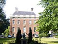
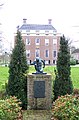
Huis Goudestein
|
This is a category about rijksmonument number 413133
|
Historische aanleg
|
This is a category about rijksmonument number 413134
|
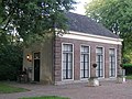
Koetshuis
|
This is a category about rijksmonument number 413135
|
Smeedijzeren hek op bakstenen dam
|
This is a category about rijksmonument number 413136
|
Smeedijzeren hek aan de Vecht op bakstenen dam
|
This is a category about rijksmonument number 413137
|
Hek naar het erf van het bouwhuis met bakstenen keermuren
|
This is a category about rijksmonument number 413138
|
Bakstenen rondboogbrug
|
This is a category about rijksmonument number 413139
|
Oranjerie
|
This is a category about rijksmonument number 413140
|
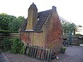
Bakhuisje
|
This is a category about rijksmonument number 470906
|
| Address |
|
Subcategories
This category has the following 2 subcategories, out of 2 total.
G
H
- Hekwerken, Goudestein (21 F)
Media in category "Goudestein"
The following 43 files are in this category, out of 43 total.
-
 413014 Goudenstein.JPG 4,000 × 3,000; 4.13 MB
-
 Aanzicht - Maarssen - 20143511 - RCE.jpg 1,200 × 849; 302 KB
-
 Achtergevel - Maarssen - 20143508 - RCE.jpg 1,200 × 802; 254 KB
-
 Brug - Maarssen - 20143512 - RCE.jpg 1,200 × 810; 283 KB
-
 Brug in het Jaagpad langs de Vecht - Maarssen - 20143526 - RCE.jpg 1,195 × 1,200; 428 KB
-
 Bruggen bij "Goudestein" - Maarssen - 20143513 - RCE.jpg 1,200 × 807; 273 KB
-
 Diependaalsedijk, bouwhuis - Maarssen - 20143507 - RCE.jpg 1,200 × 804; 314 KB
-
 Exterieur - Maarssen - 20143495 - RCE.jpg 1,200 × 955; 177 KB
-
 Exterieur OVERZICHT VOORGEVEL - Maarssen - 20314192 - RCE.jpg 1,176 × 1,200; 390 KB
-
 Goudestein efterkant.JPG 3,264 × 2,448; 1.97 MB
-
 Goudestein.JPG 2,288 × 1,712; 1.24 MB
-
 Hek aan de achterzijde - Maarssen - 20143518 - RCE.jpg 1,200 × 957; 315 KB
-
 Interieur van de gang - Maarssen - 20143500 - RCE.jpg 869 × 1,200; 195 KB
-
 Jan van IJzendoorn Endelhovenlaan Goudestein Maarssen1.JPG 1,752 × 2,568; 3.54 MB
-
 Jan van IJzendoorn Endelhovenlaan Goudestein Maarssen2.JPG 2,396 × 1,604; 3.47 MB
-
 KasteelGoudestein.JPG 790 × 587; 219 KB
-
 Koetshuis - Maarssen - 20143756 - RCE.jpg 1,200 × 809; 295 KB
-
 Maarssen 413133 Goudestein.JPG 3,072 × 2,304; 1.44 MB
-
 Maarssen 413134 Park Goudestein.JPG 3,072 × 2,304; 1.55 MB
-
 Maarssen 413135 Bijgebouwen Goudestein.JPG 2,797 × 2,098; 5.53 MB
-
 Maarssen 413140 Oranjerie Goudestein.JPG 2,892 × 2,169; 5.42 MB
-
 Maarssen 470906 Bakhuisje Goudestein.JPG 3,072 × 2,304; 1.62 MB
-
 Maarssenbroek, Netherlands - panoramio (1).jpg 2,048 × 1,148; 611 KB
-
 Maarssenbroek, Netherlands - panoramio (2).jpg 2,048 × 1,148; 593 KB
-
 Maarssenbroek, Netherlands - panoramio (3).jpg 2,048 × 1,148; 656 KB
-
 Maarssenbroek, Netherlands - panoramio (4).jpg 2,048 × 1,148; 641 KB
-
 Maarssenbroek, Netherlands - panoramio (5).jpg 2,048 × 1,148; 525 KB
-
 Maarssenbroek, Netherlands - panoramio (6).jpg 2,048 × 1,148; 579 KB
-
 Maarssenbroek, Netherlands - panoramio (7).jpg 2,048 × 1,148; 502 KB
-
 Overzicht achtergevel - Maarssen - 20143497 - RCE.jpg 1,200 × 955; 316 KB
-
 Overzicht achtergevel - Maarssen - 20143503 - RCE.jpg 1,200 × 894; 282 KB
-
 Overzicht voorgevel - Maarssen - 20143496 - RCE.jpg 1,200 × 969; 276 KB
-
 Overzicht voorgevel - Maarssen - 20143504 - RCE.jpg 1,200 × 894; 285 KB
-
 Overzicht zijgevel - Maarssen - 20143498 - RCE.jpg 963 × 1,200; 240 KB
-
 Schouw - Maarssen - 20143501 - RCE.jpg 964 × 1,200; 183 KB
-
 Stucplafond in de gang - Maarssen - 20143502 - RCE.jpg 871 × 1,200; 223 KB
-
 Stucplafond in voorkamer - Maarssen - 20143499 - RCE.jpg 1,200 × 950; 215 KB
-
 Verzetsmonument Marian Gobius Diependaalsedijk Goudestein Maarssen.JPG 1,580 × 2,400; 3.18 MB
-
 Verzetsmonument Marian Gobius Diependaalsedijk Goudestein Maarssen2.JPG 2,832 × 2,128; 4.65 MB
-
 Voorgevel - Maarssen - 20143509 - RCE.jpg 1,200 × 794; 194 KB
-
 Voorgevel, ingangspartij met gebogen bordes - Maarssen - 20143505 - RCE.jpg 894 × 1,200; 262 KB
-
 Wapen van voormalige gemeente Maarssen1.jpg 1,938 × 1,048; 949 KB
-
 Wapen van voormalige gemeente Maarssen2.jpg 2,668 × 1,832; 2.31 MB


.jpg)
.jpg)
.jpg)
.jpg)
.jpg)
.jpg)
.jpg)


