Category:Gosforth, Newcastle upon Tyne
Reason: A separate unparished area rather than in Newcastle upon Tyne unparished area so county disambiguator more appropriate
Date: tagged 17 December 2023.
Objections and discussion have their place at Category talk:Gosforth, Newcastle upon Tyne (two weeks are considered as adequate time for possible objections). See Commons:Rename a category for general information and policy.
- If the proposed rename is clearly uncontroversial or consensus-decided, place the bot command (see below) at User talk:CommonsDelinker/commands to be handled by CommonsDelinker or rename it and move the content manually. If the new destination category exists, you can remove this template, replacing it with {{category redirect|Gosforth, Tyne and Wear}}.
- If the proposal is clearly or potentially controversial or requires a broader discussion, you can transfer the discussion to Commons:Categories for discussion (replacing this template with {{subst:cfd}})
- If the proposal is clearly nonsensical, mistaken or consensually rejected, please remove this template.
Warning: processing period depends on activity of Commons volunteers. Some proposals (especially with unclear reason or too weak support) stay waiting for many months to be handled.
Bot command: {{move cat|Gosforth, Newcastle upon Tyne|Gosforth, Tyne and Wear|reason=A separate unparished area rather than in Newcastle upon Tyne unparished area so county disambiguator more appropriate}}
| − | Category:Gosforth, | + | Category:Gosforth, Tyne and Wear |
| − | Category:Gosforth, | + | Category:Gosforth, Tyne and Wear |
suburb of Newcastle-upon-Tyne, Tyne and Wear, England  | |||||
| Upload media | |||||
| Instance of |
| ||||
|---|---|---|---|---|---|
| Location | Newcastle upon Tyne, Tyne and Wear, North East England, England | ||||
 | |||||
Gosforth is an area of Newcastle upon Tyne, Tyne and Wear, England to the north of the city centre.
Subcategories
This category has the following 9 subcategories, out of 9 total.
G
- All Saints’ Church, Gosforth (2 F)
R
S
- Salters Bridge (1 F)
W
- Wansbeck Road Metro station (4 F)
Media in category "Gosforth, Newcastle upon Tyne"
The following 77 files are in this category, out of 77 total.
-
 Allotment Gardens - geograph.org.uk - 55235.jpg 640 × 475; 148 KB
-
 Asda bottle bank - geograph.org.uk - 519038.jpg 640 × 480; 110 KB
-
 ASDA Gosforth.jpg 3,072 × 1,801; 3.6 MB
-
 Blacksmiths Arms, Gosforth - geograph.org.uk - 3412629.jpg 1,824 × 1,368; 574 KB
-
 Boardwalk in Gosforth Wood - geograph.org.uk - 962839.jpg 640 × 475; 154 KB
-
 Brandling Arms, Gosforth - geograph.org.uk - 3412622.jpg 1,824 × 1,368; 576 KB
-
 Bus Stop, High Street, Gosforth - geograph.org.uk - 712574.jpg 480 × 640; 79 KB
-
 Castles Farm - geograph.org.uk - 65080.jpg 640 × 480; 58 KB
-
 Co-op Regent Farm.jpg 3,072 × 2,304; 4.01 MB
-

-
 Dyke Stone, Gosforth - geograph.org.uk - 301765.jpg 427 × 640; 100 KB
-
-
 Ettrick Lodge, The Grove, Gosforth - geograph.org.uk - 865998.jpg 640 × 427; 66 KB
-
 Evening rush hour on Gosforth High Street - geograph.org.uk - 3412611.jpg 1,708 × 1,238; 451 KB
-
 FreshXpress (Kwik Save) Fawdon.jpg 3,072 × 1,739; 2.59 MB
-
 FreshXpress Fawdon.jpg 2,730 × 1,304; 457 KB
-
 Glimpse of Gosforth Lake - geograph.org.uk - 962928.jpg 640 × 434; 84 KB
-
 Gosforth Central Middle.jpg 2,200 × 768; 198 KB
-
 Gosforth East Middle.jpg 2,600 × 1,400; 749 KB
-
 Gosforth Empire Social Club - geograph.org.uk - 1384005.jpg 640 × 490; 46 KB
-
 Gosforth fire station - geograph.org.uk - 288094.jpg 640 × 427; 227 KB
-
 Gosforth High School Building.JPG 3,072 × 844; 349 KB
-
 Gosforth High Street - geograph.org.uk - 65048.jpg 640 × 480; 51 KB
-
 Gosforth High Street 1.jpg 3,072 × 2,304; 4.25 MB
-
 Gosforth High Street 2.jpg 3,072 × 2,304; 4.22 MB
-
 Gosforth High Street 3.jpg 3,072 × 2,304; 2.5 MB
-
 Gosforth High Street 4.jpg 3,072 × 2,304; 1.96 MB
-
 Gosforth Home Farm - geograph.org.uk - 55144.jpg 640 × 475; 94 KB
-
 Gosforth Junior High Academy Key Stage 2 Entrance.jpg 5,184 × 3,456; 3.12 MB
-
 Gosforth Lake - geograph.org.uk - 962965.jpg 640 × 421; 92 KB
-
 Gosforth Library 2007.jpg 3,072 × 1,627; 798 KB
-
 Gosforth old fire station - geograph.org.uk - 1393235.jpg 640 × 427; 229 KB
-
 Gosforth Pool.jpg 3,072 × 1,342; 2.81 MB
-
 Gosforth Shopping Centre - geograph.org.uk - 3412576.jpg 1,824 × 1,368; 738 KB
-
 Gosforth Shopping Post.jpg 3,072 × 1,911; 1.75 MB
-
 Gosforth Shopping Sainsburys.jpg 3,072 × 1,785; 1.31 MB
-
 Gosforth Temp Library.jpg 3,072 × 1,686; 2.55 MB
-
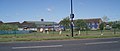
 Gosforth West Middle.jpg 3,062 × 768; 387 KB
-
 St Charles R.C. Church, Gosforth - geograph.org.uk - 613755.jpg 640 × 480; 89 KB
-
 Gosforth, Newcastle ... post office. - Flickr - BazzaDaRambler.jpg 3,282 × 3,238; 1.52 MB
-
 Gosforth, Newcastle upon Tyne ... a convergence of reds. (26182398722).jpg 5,264 × 3,968; 2.53 MB
-
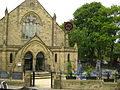
 Trinity Church - geograph.org.uk - 65050.jpg 640 × 480; 81 KB
-
 Great North Road - geograph.org.uk - 55125.jpg 640 × 475; 106 KB
-
 Great North Road mileages (Gosforth) - geograph.org.uk - 411977.jpg 408 × 306; 42 KB
-
 High Street, Gosforth - geograph.org.uk - 712598.jpg 640 × 480; 91 KB
-
 Job Bulman.jpg 2,304 × 3,072; 2.1 MB
-

-
 Little moor - geograph.org.uk - 47517.jpg 640 × 445; 108 KB
-
 Loch Fyne Bar-Grill-Restaurant on Gosforth High Street - geograph.org.uk - 3412492.jpg 1,091 × 1,699; 495 KB
-
 Loch Fyne fishmongers sign - geograph.org.uk - 3412587.jpg 1,824 × 1,368; 620 KB
-
 Mushroom in Gosforth Wood - geograph.org.uk - 962990.jpg 640 × 473; 87 KB
-
 New Housing in Melton Park - geograph.org.uk - 75122.jpg 640 × 475; 145 KB
-
 Newcastle ... bike rack in Gosforth with NE3 127. - Flickr - BazzaDaRambler.jpg 4,340 × 3,260; 2.68 MB
-
 Newcastle upon Tyne img 3462 (3657222537).jpg 3,264 × 2,448; 4.39 MB
-
 Newcastle upon Tyne img 3463 (3658015596).jpg 3,264 × 2,448; 3.7 MB
-
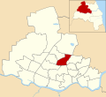
 Newcastle upon Tyne UK ward map highlighting Dene and South Gosforth.svg 1,425 × 1,305; 245 KB
-
 Newcastle upon Tyne UK ward map highlighting Fawdon and West Gosforth.svg 1,425 × 1,305; 245 KB
-
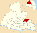
 Newcastle upon Tyne UK ward map highlighting Gosforth.svg 1,425 × 1,305; 245 KB
-
 North Gosforth - Brackenside.jpg 640 × 475; 152 KB
-
 Northern Lights Public House - geograph.org.uk - 467192.jpg 640 × 480; 80 KB
-
 Northumberland County Ground 1965.jpg 600 × 312; 73 KB
-
 Open Fields in Gosforth Park - geograph.org.uk - 958274.jpg 640 × 480; 75 KB
-
 Panneau entrée Gosforth Newcastle Tyne 1.jpg 5,184 × 3,456; 4.73 MB
-
 Panneau entrée Gosforth Newcastle Tyne 2.jpg 5,184 × 3,456; 6.81 MB
-
 Race Day.jpg 800 × 565; 187 KB
-

-
 Regent Centre, Gosforth and surrounding area, 1978 (26518989955).jpg 1,004 × 799; 601 KB
-
 Regent Farm First School.jpg 3,072 × 1,297; 673 KB
-
 Rush Hour Traffic - geograph.org.uk - 70920.jpg 640 × 480; 80 KB
-
 Salters Road - geograph.org.uk - 1383993.jpg 640 × 496; 66 KB
-
 Sanderson Hospital Gosforth signage October 2020.jpg 3,979 × 2,946; 2.02 MB
-
 The Old Chapel on Woodbine Road - geograph.org.uk - 3412652.jpg 1,824 × 1,368; 586 KB
-
 The Old Globe Cinema, Salters Road - geograph.org.uk - 65061.jpg 640 × 480; 65 KB
-
 Town Moor, Newcastle - geograph.org.uk - 16427.jpg 640 × 480; 67 KB
-
 Wansbeck Road Metro.JPG 2,917 × 1,800; 1.11 MB
-
 Wansbeck Road South.jpg 3,072 × 1,814; 2.97 MB
-
 Woodbine Road Old Chapel - geograph.org.uk - 3412713.jpg 1,368 × 1,824; 723 KB


_Fawdon.jpg)


.jpg)


_-_geograph.org.uk_-_411977.jpg)


.jpg)
.jpg)


_-_geograph.org.uk_-_65041.jpg)
.jpg)


