Category:Glockenstuhl/Wetterturm, Dürnbach
Jump to navigation
Jump to search
| Object location | | View all coordinates using: OpenStreetMap |
|---|
.jpg) | |||||
| Upload media | |||||
| Instance of | |||||
|---|---|---|---|---|---|
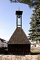
| Location | Schachendorf, Oberwart District, Burgenland, Austria | ||||
| Street address |
| ||||
| Heritage designation | |||||
 | |||||
Media in category "Glockenstuhl/Wetterturm, Dürnbach"
The following 5 files are in this category, out of 5 total.
-
 20210822 WTSB Dürnbach 5503.jpg 3,411 × 5,117; 9.16 MB
-
 20210822 WTSB Dürnbach 5504.jpg 3,015 × 4,523; 7.41 MB
-
 20210822 WTSB Dürnbach 5508.jpg 5,568 × 3,712; 10.7 MB
-
 Schachendorf - Dürnbach, Glockenstuhl-Wetterturm (01).jpg 2,000 × 3,000; 1.38 MB
-
 Schachendorf - Dürnbach, Glockenstuhl-Wetterturm 8255 WLM.jpg 2,000 × 3,000; 1.55 MB


