Category:Glaramara
Jump to navigation
Jump to search

mountain in United Kingdom  | |||||
| Upload media | |||||
| Instance of | |||||
|---|---|---|---|---|---|
| Location | Cumbria, North West England, England | ||||
| Mountain range | |||||
| Topographic prominence |
| ||||
| Elevation above sea level |
| ||||
| Parent peak | |||||
 | |||||
Deutsch: Der Glaramara ist ein Berg im Lake District, Cumbria, England. Der Glaramara ist einer der 214 von Alfred Wainwright beschriebenen Berge des Lake District. Der Glaramara ist 783 m hoch, weist aber nur eine Schartenhöhe von 121 m auf.
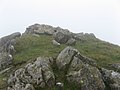
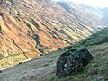
English: Glaramara is a fell in the English Lake District in Cumbria. It is a substantial fell that is part of a long ridge that stretches for over six kilometres from Stonethwaite in Borrowdale up to the important mountain pass of Esk Hause. The summit of Glaramara at 783 m (2,569 ft) is the central point of this ridge, which separates the valleys of Langstrath and Grains Gill, however the ridge has two additional fells, numerous subsidiary tops and several small tarns making its traverse an appealing and challenging walk.
Media in category "Glaramara"
The following 33 files are in this category, out of 33 total.
-
 Ascending Glaramara - geograph.org.uk - 2524220.jpg 2,560 × 1,920; 1.97 MB
-
 Ascending Glaramara - geograph.org.uk - 2526843.jpg 2,560 × 1,920; 752 KB
-
 Ascending Glaramara - geograph.org.uk - 2526845.jpg 2,560 × 1,920; 690 KB
-
 Borrowdale and Glaramara from Grange Fell.jpg 1,680 × 1,260; 117 KB
-
 Broken sign on Glaramara - geograph.org.uk - 988443.jpg 640 × 480; 91 KB
-
 Cairn at Pt721on glaramara ridge - geograph.org.uk - 939576.jpg 500 × 375; 78 KB
-
 Combe Door - geograph.org.uk - 4278935.jpg 4,608 × 3,456; 3.42 MB
-
 Combe Head Summit - geograph.org.uk - 1531737.jpg 640 × 480; 68 KB
-
 Combe Head summit cairn - geograph.org.uk - 939579.jpg 500 × 375; 86 KB
-
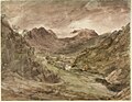 Constable - Borrowdale view towards Glaramara, 181-1888.jpg 2,176 × 1,692; 838 KB
-
 From Glaramara - geograph.org.uk - 1102886.jpg 640 × 480; 68 KB
-
 Glaramara - geograph.org.uk - 1102878.jpg 640 × 480; 60 KB
-
 Glaramara From Hind Side - geograph.org.uk - 114152.jpg 361 × 480; 49 KB
-
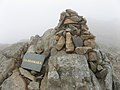 Glaramara summit cairn - geograph.org.uk - 939578.jpg 500 × 375; 83 KB
-
 On the Glaramara Ridge - geograph.org.uk - 110378.jpg 640 × 436; 77 KB
-
 Rescue Helicopter - geograph.org.uk - 353268.jpg 640 × 480; 69 KB
-
 Small Tarn Near Pinnacle Bield - geograph.org.uk - 4278930.jpg 4,608 × 3,456; 3.4 MB
-

-

-
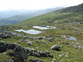 Tarns south of Combe Head - geograph.org.uk - 877583.jpg 640 × 480; 94 KB
-

-
 Borrowdale from Glaramara summit. - geograph.org.uk - 737533.jpg 640 × 427; 43 KB
-
 Cairn, Dovenest Top - geograph.org.uk - 353017.jpg 640 × 480; 88 KB
-
 Cairn, Looking Steads - geograph.org.uk - 353128.jpg 640 × 480; 76 KB
-
 Cairn, Red Beck Top - geograph.org.uk - 353231.jpg 640 × 480; 101 KB
-
 Cloudburst - geograph.org.uk - 74149.jpg 480 × 640; 60 KB
-
 Frozen Tarn , Glaramara - geograph.org.uk - 353134.jpg 640 × 480; 108 KB
-
 Glaramara - geograph.org.uk - 17313.jpg 640 × 480; 68 KB
-
 Langstrath from Dovenest Top - geograph.org.uk - 353014.jpg 640 × 480; 79 KB
-
 Looking Across Langstrath - geograph.org.uk - 247829.jpg 640 × 480; 72 KB
-
 Rosthwaite Cam - geograph.org.uk - 353019.jpg 640 × 480; 74 KB
-
 Summit Cairn, Glaramara - geograph.org.uk - 353162.jpg 640 × 480; 74 KB
-
 View Up Grains Gill - geograph.org.uk - 114440.jpg 640 × 482; 92 KB


_-_geograph.org.uk_-_713677.jpg)


