Category:Ginnekenweg 301, Breda
Jump to navigation
Jump to search
| Object location | | View all coordinates using: OpenStreetMap |
|---|
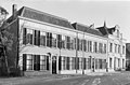
Nederlands: Afbeeldingen van de Ginnekenweg 301, 4835 NC Breda. Gelegen in de wijk het Ginneken in het zuiden van Breda in de provincie Noord-Brabant in het zuiden van Nederland
Media in category "Ginnekenweg 301, Breda"
The following 4 files are in this category, out of 4 total.
-
 2010-04-25-breda-by-RalfR-43.jpg 2,000 × 3,008; 1.9 MB
-
 Ginnekenweg P1010547 copy.jpg 3,264 × 2,448; 1.72 MB
-
 P1030658Ginnekenweg.JPG 3,264 × 2,448; 3.69 MB
-
 Voorgevels - Ginneken - 20078621 - RCE.jpg 1,200 × 788; 223 KB


