Category:Georgia State Route 117
Jump to navigation
Jump to search
 | number: | (one hundred seventeen) |
|---|---|---|
| State highways in Georgia (U.S. state): | 97 · 99 · 100 · 101 · 102 · 103 · 104 · 105 · 107 · 108 · 109 · 110 · 111 · 112 · 113 · 114 · 115 · 116 · 117 · 119 · 120 · 121 · 122 · 124 · 125 · 126 · 127 · 128 · 129 · 130 · 132 · 133 · 135 · 136 |
highway in Georgia  | |||||
| Upload media | |||||
| Instance of | |||||
|---|---|---|---|---|---|
| Location | Georgia | ||||
| Transport network | |||||
| Owned by | |||||
| Maintained by | |||||
| Length |
| ||||
| |||||
English: State Route 117 (SR 117) is a state highway that runs southeast-to-northwest in an upside down question mark around McRae. It travels through portions of Telfair, Dodge, and Laurens counties in the central part of the U.S. state of Georgia. It connects Lumber City with the Dublin, via Jacksonville and Eastman.
Media in category "Georgia State Route 117"
The following 6 files are in this category, out of 6 total.
-
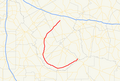 Georgia state route 117 map.png 681 × 462; 111 KB
-
 Jacksonville Fire Department, Georgia.JPG 4,608 × 3,456; 4.97 MB
-
 Jacksonville United Methodist Church, Georgia.JPG 4,608 × 3,456; 4.67 MB
-
 Jacksonville Veterans Memorial, Georgia.JPG 4,608 × 3,456; 5.23 MB
-
 Looking NE at GA87-117 Int, Dodge County.JPG 4,608 × 3,456; 5.58 MB
-
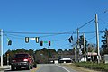 US319 US441 NB GA 117 Intersection.jpg 5,184 × 3,456; 5.61 MB


