Category:Geological maps of Nebraska
Jump to navigation
Jump to search
States of the United States: Alabama · Alaska · Arizona · Arkansas · California · Colorado · Connecticut · Delaware · Florida · Georgia · Hawaii · Idaho · Illinois · Indiana · Iowa · Kansas · Kentucky · Louisiana · Maine · Maryland · Massachusetts · Michigan · Minnesota · Mississippi · Missouri · Montana · Nebraska · Nevada · New Hampshire · New Jersey · New Mexico · New York · North Carolina · North Dakota · Ohio · Oklahoma · Oregon · Pennsylvania · Rhode Island · South Carolina · South Dakota · Tennessee · Texas · Utah · Vermont · Virginia · Washington · West Virginia · Wisconsin · Wyoming
Puerto Rico
Puerto Rico
Subcategories
This category has the following 3 subcategories, out of 3 total.
*
M
Media in category "Geological maps of Nebraska"
The following 5 files are in this category, out of 5 total.
-
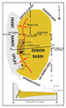 Denver Basin Location Map.png 750 × 1,225; 30 KB
-
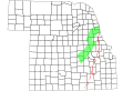 Humboldt Fault.svg 2,233 × 1,517; 176 KB
-
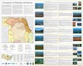 Level IV ecoregions, Nebraska and Kansas.pdf 6,654 × 5,264; 3.36 MB
-
 Midcontinent Rift map.PNG 774 × 675; 55 KB
-
 Scotts Bluff National Monument geologic map.jpg 897 × 824; 203 KB


