Category:Geological maps of Africa
Jump to navigation
Jump to search
- please tag SVG-maps by Category:SVG geology
Subcategories
This category has the following 8 subcategories, out of 8 total.
Media in category "Geological maps of Africa"
The following 85 files are in this category, out of 85 total.
-
 EB1911 Africa Geology.JPG 1,069 × 1,169; 1.03 MB
-
 Kimberlite Pipes in Africa.png 680 × 608; 74 KB
-
 Paleogene Afro-Arabian hyaenodontidan map.png 2,388 × 2,232; 79 KB
-
 19 of 'Le Sahara. ... Avec 36 cartes et gravures, etc' (11220761523).jpg 2,432 × 1,487; 834 KB
-
 1952 geological map of East Africa.tif 17,989 × 24,626; 1.24 GB
-
 76 of 'Afrika. Eine allgemeine Landeskunde, etc' (11211211334).jpg 2,784 × 1,747; 1.48 MB
-
 77 of 'Afrika. Eine allgemeine Landeskunde, etc' (11208397796).jpg 2,784 × 1,817; 1.21 MB
-

-
 A Grace gravity model, showing Europe and Africa.jpg 500 × 500; 57 KB
-
 ATJ map (color).jpg 1,686 × 2,213; 481 KB
-
 France, Ile Amsterdam.png 1,880 × 2,480; 5.34 MB
-
 Arabian-Nubian Shield-fr.svg 1,181 × 1,494; 49 KB
-
 Arabian-Nubian Shield.svg 1,181 × 1,494; 49 KB
-
 Arabisch-Nubischer Schild Metamorphe Fazies.jpg 533 × 866; 177 KB
-
 Arabisch-Nubischer Schild mit Krustendomainen und -alter.jpg 489 × 885; 171 KB
-
 Aswa Dislocation.svg 524 × 810; 24 KB
-
 Simplified geologic map of the Barberton greenstone belt.pdf 1,666 × 1,250; 224 KB
-
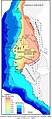 Bassin sénégalo-mauritano-guinéen.jpg 1,415 × 3,238; 814 KB
-
 Benue Trough.svg 327 × 358; 33 KB
-
 Bulletin de la Société géologique de France (1888) (19815799244).jpg 2,816 × 1,472; 1.1 MB
-
 Bulletin de la Société géologique de France (1890) (20243337090).jpg 2,816 × 1,666; 1.92 MB
-
 Bulletin de la Société géologique de France (1907) (20249146678).jpg 2,320 × 2,964; 975 KB
-
 Bulletin de la Société géologique de France BHL47100632.jpg 3,867 × 3,234; 1.59 MB
-
 Cameroon line.svg 300 × 361; 33 KB
-
 Carte du Maroc-01.png 1,622 × 1,764; 712 KB
-
 Carte Geologique Europe cropped Middle East.JPG 1,022 × 684; 130 KB
-
 Carte géologique Algérie.jpg 2,143 × 2,908; 1.82 MB
-
 Carte lithologique d'Ait Idris.jpg 3,520 × 1,738; 1.86 MB
-
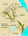 Central African Rifts-fr.svg 730 × 923; 70 KB
-
 Central African Rifts.svg 730 × 923; 57 KB
-
 Central African Shear Zone-fr.svg 576 × 395; 47 KB
-
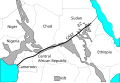 Central African Shear Zone.svg 576 × 395; 46 KB
-
 USGS geologic map Ivory Coast.png 1,231 × 786; 1.36 MB
-
 Distribution of crustal domains in the East African Orogen.jpg 377 × 790; 132 KB
-
 EAfrica1.jpg 454 × 382; 38 KB
-
 Erongo Geology.png 4,731 × 3,891; 3.13 MB
-

-
-
 Ethnographische Übersicht der Völker des äquatorialen Ost-Afrika von Dr. Franz Stuhlmann.jpg 19,464 × 14,877; 81.44 MB
-
 Francevillian basin geology.png 1,104 × 1,240; 352 KB
-

-
 Geologische Skizze von Afrika - DPLA - 01b40796a014cd4331caa99c3bc8bc05.jpg 780 × 1,000; 330 KB
-
 USGS geologic map Ghana.png 953 × 921; 241 KB
-
 Great Dyke geologic map.png 670 × 855; 105 KB
-
 USGS geologic map Guinea.png 1,360 × 926; 997 KB
-
 USGS geologic map Siguiri.png 1,628 × 903; 1.04 MB
-
 Image taken from page 631 of 'Through Masai Land. Third edition' (11178988093).jpg 3,874 × 3,604; 2.37 MB
-
 Interval de discontinuïtat Escarpament Drakensberg.jpg 917 × 682; 399 KB
-
 Cape-Vaal Craton.png 3,472 × 2,344; 159 KB
-
 Map of Kaapvaal craton in southern Africa..PNG 492 × 322; 38 KB
-
 Map of Kaapvaal craton-es- Mapa craton Kaapvaal.svg 335 × 265; 35 KB
-
 Map of Kaapvaal craton-fr.svg 335 × 265; 35 KB
-
 Map of Kaapvaal craton.svg 335 × 265; 35 KB
-
 Kamerunlinie.svg 300 × 361; 36 KB
-
 Geology of Karoo Supergroup.png 5,960 × 3,625; 292 KB
-
-
-
 Lembah Celah Besar Afrika-Asia.jpg 2,256 × 3,840; 1.09 MB
-
 Lembah Celah Besar Afro-Asia.jpg 1,510 × 3,072; 1.24 MB
-
 Lembah Celah Besar di Afrika Timur.jpg 4,000 × 4,000; 474 KB
-
 Location of the Delta Field and Cross Section Across the Niger Delta.png 799 × 1,132; 60 KB
-

-
 USGS geologic map Mali's Birimian.png 1,048 × 787; 400 KB
-
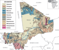 Mali geologic map.png 1,095 × 927; 659 KB
-
 Map Geological Map of Africa 1928-1940 - Touring Club Italiano CART-TRC-24.jpg 6,669 × 6,776; 25.4 MB
-
 Morocco phosphate basins.png 521 × 599; 120 KB
-
 Mosambik Gürtel mit Krustendomainen und -alter.jpg 711 × 992; 237 KB
-
 Mosambik Gürtel Strukturelle und metamorphe Fazies.jpg 581 × 845; 171 KB
-
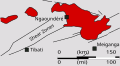 Ngaoundere Plateau.svg 299 × 163; 15 KB
-
 Niger Delta Geologic map.png 687 × 565; 344 KB
-
 Owambo Basin.jpg 1,282 × 716; 90 KB
-
 Piton Fournaise 1972-2000 eruptions-fr.svg 1,000 × 1,166; 554 KB
-
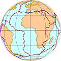 Plaque Africaine.JPG 1,134 × 1,134; 151 KB
-
 S.A. mining and engineering journal (1113) (14759127476).jpg 3,344 × 2,506; 932 KB
-
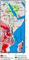
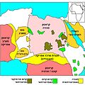 Saharan Metacraton he.jpg 2,000 × 2,000; 402 KB
-
 Saharan Metacraton HE.svg 489 × 423; 85 KB
-
 Saharan Metacraton-fr.svg 489 × 423; 84 KB
-
 Saharan Metacraton.svg 489 × 423; 83 KB
-
 Cratons d afrique australe.svg 360 × 247; 49 KB
-
 Southern African Cratons.svg 360 × 247; 49 KB
-
 Taoudeni Basin Map.gif 339 × 218; 3 KB
-
 The Quarterly journal of the Geological Society of London (1913) (14761738956).jpg 2,896 × 1,712; 566 KB
-
 The Quarterly journal of the Geological Society of London (1916) (14784634142).jpg 1,584 × 2,640; 1.06 MB
-
 West African Basins.svg 614 × 468; 100 KB
-
 West African Craton.svg 361 × 357; 165 KB


.jpg)
.jpg)
.jpg)
%27_(11293919734).jpg)

.jpg)


_(19815799244).jpg)
_(20243337090).jpg)
_(20249146678).jpg)


_-_pa_Henry_Hubert..._-_btv1b53064711z.jpg)


.jpg)


._Traduit_de_l%27allemand,_avec_l%27autorisation_de_l%27auteur_et_annot%C3%A9e_sous_la_direction_de_Emm._de_Margerie._Avec_une_pr%C3%A9f._par_Marcel_Bertrand_(1897)_(14591431310).jpg)
._Traduit_de_l%27allemand,_avec_l%27autorisation_de_l%27auteur_et_annot%C3%A9e_sous_la_direction_de_Emm._de_Margerie._Avec_une_pr%C3%A9f._par_Marcel_Bertrand_(1897)_(14755136266).jpg)


_(7773305692).jpg)


_(14759127476).jpg)


_(14761738956).jpg)
_(14784634142).jpg)

