Category:Geological diagrams in French
Jump to navigation
Jump to search
Subcategories
This category has the following 8 subcategories, out of 8 total.
- Geological diagrams of Paris (3 F)
*
F
- Fault schemas in French (5 F)
G
Q
- QAPF diagrams in French (6 F)
V
Media in category "Geological diagrams in French"
The following 107 files are in this category, out of 107 total.
-
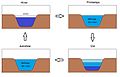
 Action du vent sur un lac.png 569 × 309; 5 KB
-
 Activité du Rift.PNG 456 × 468; 9 KB
-
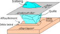 Affouillement glace 3D.svg 454 × 256; 22 KB
-
 Al2SiO5 diagramme phase.png 548 × 600; 33 KB
-
 ANDRA bloc laboratoire-2004-09.svg 1,017 × 758; 63 KB
-
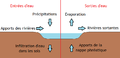 Apports et pertes d'eau dans un lac.png 841 × 406; 14 KB
-
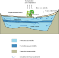 Aquifer-fr.svg 672 × 665; 35 KB
-
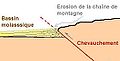 Bassin molassique.JPG 533 × 270; 18 KB
-
 Briançonnais modèles 7F.jpg 1,677 × 1,896; 385 KB
-
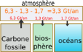
 Carbone flux2.png 1,157 × 1,400; 89 KB
-
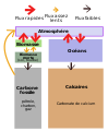 Carbone flux2.svg 1,157 × 1,400; 25 KB
-
 Cipo1.png 426 × 155; 3 KB
-
 Contact metamorphism.svg 1,451 × 912; 477 KB
-
 Coupe cheminée hydrothermale.svg 534 × 356; 55 KB
-
 Coupe dorsale océanique.svg 762 × 910; 65 KB
-
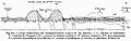 Coupe géologique montagnes Noires.jpg 780 × 245; 69 KB
-
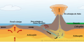
 Coupe Structure volcanique en éruption C.JPG 750 × 814; 122 KB
-
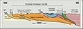
 CoupeHimal2 (cropped).jpg 693 × 231; 85 KB
-
 CoupeHimal2.jpg 730 × 254; 111 KB
-
 Coupes falaises côte albâtre 1.png 933 × 1,208; 125 KB
-
 Cycle carbone1-2009-15-02.png 1,023 × 570; 20 KB
-
 Cycle carbone1.png 1,023 × 570; 20 KB
-
 Cycle géologique.png 2,992 × 2,275; 33 KB
-
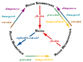
 Cycle orogénique.png 1,790 × 2,490; 615 KB
-
 Cycles régressifs de comblement.jpg 768 × 862; 105 KB
-
 Différenciation magmatique.png 1,867 × 1,205; 1.35 MB
-
 Discordances successives Jurassique Préalpes.jpg 2,304 × 1,695; 563 KB
-
 Déséquilibre du cycle du carbone.png 535 × 338; 45 KB
-
 Earth-crust-cutaway-french.svg 427 × 333; 38 KB
-
 Earthquake cycle.png 754 × 355; 72 KB
-
 Espace d'accommodation.png 1,133 × 492; 52 KB
-
 Faciès métamorphiques.png 1,027 × 682; 54 KB
-
 Faciès à éclogites.gif 1,123 × 794; 169 KB
-
 Fault types TypesDeFailles.jpg 144 × 360; 43 KB
-
 Foreland-01.png 1,625 × 556; 47 KB
-
 Formation 1.png 394 × 178; 21 KB
-
 Formation 3.png 394 × 178; 29 KB
-
 Formation 4.png 394 × 178; 35 KB
-
 Formation d'un nouvel océan et dérive des continents.PNG 680 × 769; 29 KB
-
 Formation des roches couleur.png 800 × 600; 64 KB
-
 Formation des roches.png 459 × 500; 75 KB
-
 Formation des vouas du Lyaud.jpg 1,117 × 1,092; 357 KB
-
 Formation du lac d' Arvouin.jpg 794 × 1,229; 315 KB
-
 Formation marbre 2.png 394 × 178; 26 KB
-
 Fusion expérimentale de la péridotite.jpg 715 × 161; 25 KB
-
 Geological History of Nauru-fr.png 734 × 1,051; 401 KB
-
 Geologie - Model PREM - Preliminary Reference Earth Model.svg 744 × 744; 344 KB
-
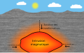
 Geothermie piton des neiges.jpg 1,352 × 821; 104 KB
-
 Glacial landscape FR.PNG 388 × 230; 37 KB
-
 Gold Cycle In California-fr.svg 850 × 425; 58 KB
-
 Infiltration.jpg 550 × 418; 166 KB
-
 Isthme.svg 730 × 433; 7 KB
-
 Katabatic-wind fr.svg 512 × 512; 11 KB
-
 Lits d'un fleuve.png 825 × 388; 6 KB
-
 Mangaiacoupe.png 1,271 × 498; 50 KB
-
 Meander-fr.svg 692 × 344; 21 KB
-
 Megamullion by JAO.JPG 892 × 447; 50 KB
-
 Megamullion by JAO.svg 750 × 340; 38 KB
-
 Mer de craie.png 963 × 769; 611 KB
-
 Metam.jpg 356 × 323; 72 KB
-
 Metamorphism P-T diagram.svg 1,280 × 751; 248 KB
-
 Miers profil topographique geologique V1.png 936 × 630; 103 KB
-
 Miers profil topographique geologique.png 936 × 630; 101 KB
-
 Mines de LBDC et SGLF.png 1,410 × 794; 240 KB
-
 Modélisation contraintes.PNG 545 × 325; 6 KB
-
 MéandresCheveluFleuvesFL.jpg 1,024 × 768; 150 KB
-
 Métamorphisme subduction.svg 741 × 620; 1.05 MB
-
 Normal Faults in Cliff in Biarritz in France - Interpretation.jpg 872 × 412; 31 KB
-
 Oceanic-continental convergence Fig21oceancont (french).png 450 × 265; 108 KB
-
 Oceanic.Stripe.Magnetic.Anomalies.Scheme.fr.gif 260 × 190; 17 KB
-
 Oceanisation.svg 744 × 1,052; 40 KB
-
 Paléoplatiers (cropped).png 857 × 645; 168 KB
-
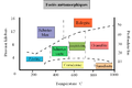
 Phanerozoic Sea Level-fr.svg 523 × 360; 24 KB
-
 Pillow Lava.PNG 616 × 279; 6 KB
-
 PlacerFR-01.png 1,321 × 646; 217 KB
-
 Plis géologiques.jpg 354 × 227; 11 KB
-
 Possible Methane Sources and Sinks on Mars-fr.jpg 1,440 × 1,080; 880 KB
-
 PTmeta.jpg 271 × 264; 14 KB
-
 Pétrologie.png 711 × 720; 73 KB
-
 Radon-coupe-geol.png 776 × 170; 16 KB
-
 Relief de cuesta copie.jpg 1,907 × 796; 243 KB
-
 Ride médio océanique.PNG 649 × 368; 13 KB
-
 Ride médio océanique.svg 649 × 368; 8 KB
-
 Rift actif Rift passif.jpg 604 × 261; 16 KB
-
 Rift shoulders.svg 744 × 1,052; 43 KB
-
 Rivierbedding fr.png 1,324 × 755; 294 KB
-
 Schéma Bastberg (1).jpg 983 × 714; 249 KB
-
 Schéma Bastberg.jpg 983 × 714; 97 KB
-
 Schéma d'un canyon sous-marin de type gouf.jpg 1,280 × 720; 132 KB
-
 Schéma glacier rocheux type.png 2,999 × 2,192; 752 KB
-
 Schéma-plateau-continental.gif 607 × 221; 5 KB
-
 Seabed gouging by ice 2D Fr.svg 931 × 648; 29 KB
-
 Simplified subduction.svg 1,052 × 531; 50 KB
-
 Strati.jpg 400 × 771; 116 KB
-
 Stratification des eaux d'un lac suivant la saison.jpg 866 × 554; 54 KB
-
 Subduction Convergence Océan Continent.png 732 × 265; 113 KB
-
 Subduction océanique.PNG 669 × 192; 8 KB
-
 Subduction-fr.svg 1,052 × 531; 91 KB
-
 Subduction-fr2.svg 1,592 × 1,200; 1.23 MB
-
 Séisme-Épicentre-Hypocentre-Faille tectonique.jpg 337 × 221; 36 KB
-
 Tableau-lindal.jpg 885 × 516; 111 KB
-
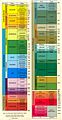
 TAS-francais.png 636 × 548; 151 KB
-
 Théorie LaTerre 22112013.JPG 1,056 × 548; 163 KB
-
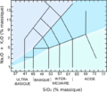
 TriangleSLA.png 640 × 411; 59 KB
-
 Turbidite.png 2,414 × 1,451; 260 KB
-
 Yellowstone Caldera fr.svg 560 × 292; 59 KB
-
 Zone de subduction djareku.png 264 × 176; 11 KB


.png)


.png)


.jpg)


.jpg)