Category:Geographic overlays by User:Omnedon
Jump to navigation
Jump to search
Geographic overlays created by User:Omnedon.
Media in category "Geographic overlays by User:Omnedon"
The following 19 files are in this category, out of 19 total.
-
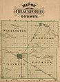 Blackford County, Indiana map from 1876 atlas.jpg 1,242 × 1,704; 1.59 MB
-
 Covington, Indiana map from 1876 atlas.jpg 1,302 × 946; 862 KB
-
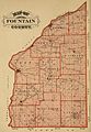 Fountain County, Indiana map from 1876 atlas.jpg 1,521 × 2,190; 2.59 MB
-
 Green Hill Indiana map from 1877 atlas.png 1,024 × 1,011; 2.18 MB
-
 Independence Indiana map from 1877 atlas.png 1,024 × 802; 1.8 MB
-
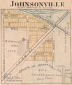 Johnsonville Indiana map from 1877 atlas.png 1,280 × 1,491; 3.06 MB
-
 Kickapoo, Indiana plat.png 1,800 × 1,800; 4.07 MB
-
 Map of Corydon, Indiana from 1876 atlas.png 950 × 948; 880 KB
-
 Map of Oxford, Indiana from 1876 atlas.png 1,630 × 1,024; 1.68 MB
-
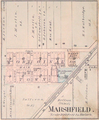 Marshfield Indiana map from 1877 atlas.png 1,280 × 1,556; 3 MB
-
 Pike Township, Warren County, Indiana map from 1877 atlas.png 1,473 × 2,048; 5.29 MB
-
 Pine Village Indiana map from 1877 atlas.png 871 × 1,024; 1.86 MB
-
 Rainsville Indiana map from 1877 atlas.png 717 × 1,024; 1.62 MB
-
 State Line City Indiana map from 1877 atlas.png 1,632 × 1,330; 3.74 MB
-
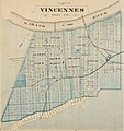 Vincennes, Indiana map from 1876 atlas.JPG 1,501 × 1,600; 1.88 MB
-
 Warren County, Indiana map from 1877 atlas.png 1,698 × 2,048; 6.62 MB
-
 Washington Township, Warren County, Indiana map from 1877 atlas.png 2,048 × 1,655; 6.52 MB
-
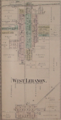 West Lebanon, Indiana map from 1877 atlas.png 948 × 1,863; 2.73 MB
-
 Williamsport, Indiana map from 1877 atlas.png 1,665 × 2,048; 6.72 MB


