Category:Gemaal De Lege Wâlden
Jump to navigation
Jump to search
| Object location | | View all coordinates using: OpenStreetMap |
|---|
_01.jpg) | |||||
| Upload media | |||||
| Instance of | |||||
|---|---|---|---|---|---|
| Location | De Fryske Marren, Friesland, Netherlands | ||||
 | |||||
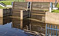
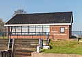
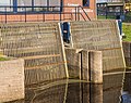
Gemaal De Lege Wâlden Terkaple in de gemeente De Fryske Marren.
Pumping water station De Lege Wâlden Terkaple in the municipality of De Fryske Marren.
Media in category "Gemaal De Lege Wâlden"
The following 6 files are in this category, out of 6 total.
-
 Terkaple (actm) 01.jpg 5,033 × 3,355; 13.67 MB
-
 Terkaple (actm) 02.jpg 3,982 × 2,312; 7.71 MB
-
 Terkaple (actm) 03.jpg 4,978 × 3,085; 14.03 MB
-
 Terkaple (actm) 04.jpg 4,884 × 3,223; 14.01 MB
-
 Terkaple (actm) 05.jpg 4,825 × 3,347; 11.92 MB
-
 Terkaple (actm) 06.jpg 4,111 × 3,256; 11.95 MB
_02.jpg)
_03.jpg)
_04.jpg)
_05.jpg)
_06.jpg)