Category:Garz (Temnitztal)
Jump to navigation
Jump to search
| Object location | | View all coordinates using: OpenStreetMap |
|---|
village in Brandenburg state, Germany _2015_NW.jpg) | |||||
| Upload media | |||||
| Instance of |
| ||||
|---|---|---|---|---|---|
| Location | Temnitztal, Ostprignitz-Ruppin District, Brandenburg, Germany | ||||
 | |||||
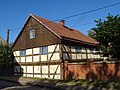
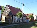
English: The village Garz is part of Temnitztal municipality, Ostprignitz-Ruppin district, Brandenburg state, Germany
Deutsch: Das Dorf Garz gehört zur Gemeinde Temnitztal, Landkreis Ostprignitz-Ruppin, Land Brandenburg, Deutschland.
Français : Le village de Garz fait partie de la commune de Temnitztal, arrondissement Prignitz-de-l'Est-Ruppin, état fédéral de Brandebourg, Allemagne
Subcategories
This category has only the following subcategory.
D
- Dorfkirche Garz (Temnitztal) (1 P, 14 F)
Media in category "Garz (Temnitztal)"
The following 11 files are in this category, out of 11 total.
-
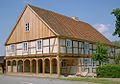 Garz Vorlaubenhaus.jpg 1,000 × 700; 201 KB
-
 GarzLuchdamm1.jpg 3,399 × 2,548; 3.82 MB
-
 GarzLuchdamm17.jpg 3,648 × 2,736; 5.47 MB
-
 GarzLuchdamm18.jpg 3,648 × 2,736; 3.42 MB
-
 GarzLuchdamm2.jpg 3,029 × 2,274; 3.39 MB
-
 GarzRotdorn11.jpg 3,648 × 2,736; 2.45 MB
-
 GarzRotdorn12.jpg 3,130 × 2,345; 3.57 MB
-
 GarzRotdorn16.jpg 2,945 × 2,206; 2.51 MB
-
 GarzRotdorn18.jpg 2,810 × 2,120; 2.44 MB
-
 GarzRotdorn5.jpg 3,096 × 2,354; 3.85 MB
-
 GarzRotdorn6.jpg 2,924 × 2,197; 3.57 MB


