Category:Frilford
Jump to navigation
Jump to search
village and civil parish in Vale of White Horse district, Oxfordshire, England  | |||||
| Upload media | |||||
| Instance of | |||||
|---|---|---|---|---|---|
| Location | Vale of White Horse, Oxfordshire, South East England, England | ||||
 | |||||
English: Frilford is a village and civil parish in Oxfordshire, England. In 1974 it was transferred from Berkshire. It lies 3 miles west of Abingdon, at the junction of the A415 and A338 roads.
Media in category "Frilford"
The following 84 files are in this category, out of 84 total.
-
 'Dry Leys' - geograph.org.uk - 4792729.jpg 1,024 × 683; 177 KB
-
 A double decker bus outside Millets Garden Centre - geograph.org.uk - 4692298.jpg 3,648 × 2,736; 2.54 MB
-
 A goat at Millets Farm Petting Zoo - geograph.org.uk - 2235987.jpg 1,500 × 1,142; 294 KB
-

-
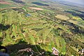 Aerial view of Frilford Heath Golf Club - geograph.org.uk - 3447982.jpg 4,288 × 2,848; 5.04 MB
-

-

-
 Benchmark on Frilford Evangelical Chapel - geograph.org.uk - 4800571.jpg 683 × 1,024; 280 KB
-
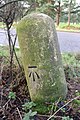 Benchmark on milestone beside A338 - geograph.org.uk - 4811737.jpg 683 × 1,024; 228 KB
-

-
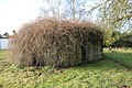 Covered in shrub - geograph.org.uk - 2203439.jpg 1,024 × 683; 302 KB
-
 Dog House Hotel, near Frilford Heath - geograph.org.uk - 60954.jpg 640 × 480; 96 KB
-
 Door on the back - geograph.org.uk - 1271757.jpg 640 × 426; 53 KB
-
 East end of Frilford Evangelical Church - geograph.org.uk - 4792687.jpg 1,024 × 683; 231 KB
-
 Emergency Access - geograph.org.uk - 3808581.jpg 1,600 × 1,187; 394 KB
-
 Emplacement in the trees - geograph.org.uk - 1266169.jpg 640 × 426; 79 KB
-
 Emplacement in the trees - geograph.org.uk - 1273290.jpg 640 × 426; 59 KB
-
 Entrance in the pillbox - geograph.org.uk - 2203445.jpg 1,024 × 683; 172 KB
-
 Entrance to Frilford Heath Golf Club from A338 - geograph.org.uk - 4761915.jpg 1,024 × 683; 234 KB
-
 Entrance to Frilford Heath Golf Club from A338 - geograph.org.uk - 4792599.jpg 1,024 × 683; 219 KB
-
 Farm track near Fyfield - geograph.org.uk - 6311741.jpg 4,608 × 3,456; 7.66 MB
-
 Farmland near Fyfield - geograph.org.uk - 2832599.jpg 640 × 429; 199 KB
-
 Field near Garford - geograph.org.uk - 5032146.jpg 1,500 × 1,125; 251 KB
-
 Footbridge over the A415 - geograph.org.uk - 1878110.jpg 640 × 480; 78 KB
-

-
 Ford Lane, Frilford - geograph.org.uk - 4461659.jpg 4,000 × 3,000; 3.29 MB
-
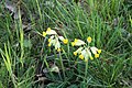 Cowslips on the ditch - geograph.org.uk - 1273232.jpg 640 × 426; 87 KB
-
 Creeping over - geograph.org.uk - 1273190.jpg 640 × 426; 75 KB
-
 Deer on the run - geograph.org.uk - 1273397.jpg 640 × 426; 61 KB
-
 Ditch by the pillbox - geograph.org.uk - 1271727.jpg 640 × 426; 95 KB
-
 Least it is clean - geograph.org.uk - 1271815.jpg 640 × 426; 52 KB
-
 Looking out of the ditch - geograph.org.uk - 1271737.jpg 640 × 426; 88 KB
-
 Old Milestone by the A338, north of Frilford (geograph 5622401).jpg 640 × 960; 207 KB
-
 Other side of the hedge - geograph.org.uk - 1271809.jpg 640 × 426; 91 KB
-
 Part added on - geograph.org.uk - 1271790.jpg 640 × 426; 78 KB
-
 Frilford Evangelical Chapel - geograph.org.uk - 4800593.jpg 1,024 × 683; 215 KB
-
 Frilford Heath Golf Club - geograph.org.uk - 6269582.jpg 800 × 600; 99 KB
-
 Frilford Heath Golf Club northern course near the car park - geograph.org.uk - 6233204.jpg 3,492 × 2,452; 2.44 MB
-
 Frilford Heath Golf Course - geograph.org.uk - 2969540.jpg 3,648 × 2,736; 2.54 MB
-
 Frilford Heath Telephone Exchange - geograph.org.uk - 4388920.jpg 3,072 × 2,304; 1.78 MB
-
 Frilford Preparatory school.jpg 640 × 480; 100 KB
-
 Frilford Service Station - geograph.org.uk - 2301971.jpg 1,500 × 1,000; 126 KB
-
 Garden Centre 1 - Millets farm - geograph.org.uk - 1013928.jpg 640 × 466; 72 KB
-
 Garden Centre 2 - Millets Farm - geograph.org.uk - 1013935.jpg 640 × 480; 131 KB
-
 Getting a clearer view - geograph.org.uk - 1271706.jpg 640 × 426; 69 KB
-
 Hedgerow beside the A338 (Oxford Road) - geograph.org.uk - 4792629.jpg 1,024 × 629; 190 KB
-
 Junction of Manor Farm track and footpath - geograph.org.uk - 4792703.jpg 1,024 × 683; 175 KB
-
 Lake at Millets Farm - geograph.org.uk - 2236058.jpg 1,500 × 1,000; 199 KB
-
 Lake at Millets Farm - geograph.org.uk - 2236060.jpg 1,500 × 994; 182 KB
-
 Lake at Millets Farm - geograph.org.uk - 2236063.jpg 1,500 × 999; 242 KB
-
 Milestone beside the A338 - geograph.org.uk - 4792609.jpg 683 × 1,024; 342 KB
-
 Millet's Farm - geograph.org.uk - 1252229.jpg 640 × 480; 58 KB
-
 Millet's Farm Garden Centre - geograph.org.uk - 1252225.jpg 640 × 480; 109 KB
-
 Millets Farm Petting Zoo - geograph.org.uk - 2235969.jpg 1,500 × 975; 204 KB
-
 Millets Farm Petting Zoo - geograph.org.uk - 2236054.jpg 1,500 × 1,000; 182 KB
-
 Millets Farm restaurant - geograph.org.uk - 2235982.jpg 1,500 × 991; 170 KB
-
 Millets Farm Shop - geograph.org.uk - 6311748.jpg 4,608 × 3,456; 5.09 MB
-
 Millets Garden Centre - geograph.org.uk - 2297466.jpg 800 × 533; 82 KB
-
 Millets Maize Maze - geograph.org.uk - 4029435.jpg 1,024 × 631; 176 KB
-
 Oops....(Police Aware) - geograph.org.uk - 4440013.jpg 3,808 × 2,844; 2.79 MB
-
 Part of Frilford Heath Golf Club course - geograph.org.uk - 6233193.jpg 4,000 × 3,000; 3.73 MB
-
 Phoebe Wood at Millets Farm Centre - geograph.org.uk - 4691839.jpg 3,648 × 2,736; 2.45 MB
-
 Pillbox by the hedge - geograph.org.uk - 1271686.jpg 640 × 426; 63 KB
-

-
 Pollarding at Frilford - geograph.org.uk - 2832591.jpg 640 × 469; 202 KB
-
 R. Woodford ^ Sons Carousel, Millets Farm Centre - geograph.org.uk - 6311745.jpg 4,608 × 3,456; 4.73 MB
-
 R. Woodford ^ Sons Carousel, Millets Farm Centre - geograph.org.uk - 6311746.jpg 4,608 × 3,456; 6.34 MB
-
 River Ock near Garford - geograph.org.uk - 3512468.jpg 4,320 × 3,240; 4.12 MB
-

-
 Shed and pillbox - geograph.org.uk - 1273273.jpg 640 × 426; 85 KB
-
 Shutter on the loophole - geograph.org.uk - 1271766.jpg 640 × 426; 73 KB
-
 Sign in the distance - geograph.org.uk - 1273363.jpg 640 × 426; 71 KB
-
 Sunset over Frilford Heath golf club - geograph.org.uk - 2298231.jpg 2,816 × 2,112; 1.21 MB
-
 Telephone Box and Exchange, Frilford Heath - geograph.org.uk - 4388923.jpg 3,072 × 2,304; 1.79 MB
-
 The A338 to Frilford Heath - geograph.org.uk - 2301977.jpg 1,500 × 1,000; 142 KB
-
 The car park at Millet's Farm - geograph.org.uk - 1483495.jpg 640 × 427; 67 KB
-
 The Dog House at Frilford Heath - geograph.org.uk - 1772358.jpg 1,500 × 1,000; 169 KB
-
 The Dog House Hotel, Frilford Heath - geograph.org.uk - 2298226.jpg 2,816 × 2,112; 1.81 MB
-
 The second this side - geograph.org.uk - 1271698.jpg 640 × 426; 53 KB
-
 The Victoria history of Berkshire (Page 207) BHL22112008.jpg 1,994 × 3,392; 735 KB
-
 Track past Manor Farm towards the A415 - geograph.org.uk - 4792715.jpg 1,024 × 683; 266 KB
-
 Wire cow at Millets Farm - geograph.org.uk - 2236068.jpg 1,000 × 1,500; 261 KB
-
 Would go that way - geograph.org.uk - 1273203.jpg 640 × 426; 90 KB
-
 The Dog House - geograph.org.uk - 309134.jpg 640 × 480; 80 KB


.jpg)


_-_geograph.org.uk_-_4792629.jpg)


_-_geograph.org.uk_-_4440013.jpg)


_BHL22112008.jpg)


