Category:Friedrichstraße 18-20 (Hückeswagen)
Jump to navigation
Jump to search
| Object location | | View all coordinates using: OpenStreetMap |
|---|
Subcategories
This category has only the following subcategory.
S
- Stadtbibliothek Hückeswagen (2 F)
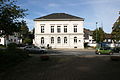
Pages in category "Friedrichstraße 18-20 (Hückeswagen)"
This category contains only the following page.
Media in category "Friedrichstraße 18-20 (Hückeswagen)"
The following 8 files are in this category, out of 8 total.
-
 Hueckeswagen-Stadtbibliothek1-Asio.JPG 1,477 × 1,120; 959 KB
-
 Hückeswagen - Friedrichstraße18 Stadtbibliothek 01 ies.jpg 3,888 × 2,592; 1.42 MB
-
 Hückeswagen - Friedrichstraße18 Stadtbibliothek 02 ies.jpg 3,888 × 2,592; 1.18 MB
-
 Hückeswagen - Friedrichstraße18 Stadtbibliothek 03 ies.jpg 3,888 × 2,592; 1.19 MB
-
 Hückeswagen - Friedrichstraße18 Stadtbibliothek 05 ies.jpg 3,888 × 2,592; 1.2 MB
-
 Hückeswagen - Friedrichstraße18 Stadtbibliothek 07 ies.jpg 3,888 × 2,592; 1.49 MB
-
 Hückeswagen - Friedrichstraße18-20 01 ies.jpg 3,888 × 2,592; 2.24 MB
-
 Hückeswagen - Friedrichstraße18-20 02 ies.jpg 3,888 × 2,592; 2.62 MB


