Category:French-language maps of the United States
Jump to navigation
Jump to search
Countries of the Americas: Brazil · Canada · Mexico · Saint Kitts and Nevis · United States of America · Venezuela
Subcategories
This category has the following 2 subcategories, out of 2 total.
Media in category "French-language maps of the United States"
The following 67 files are in this category, out of 67 total.
-
 1755 Bellin Map of the Great Lakes - Geographicus - GreatLakes-bellin-1755.jpg 4,000 × 3,215; 3.49 MB
-
 1756 Bellin Map of Boston, Massachusetts - Geographicus - Boston-bellin-1756.jpg 3,334 × 2,100; 2.07 MB
-
 1756 Bellin Map of Boston, Massachusetts - Geographicus - Boston2-bellin-1756.jpg 2,500 × 1,554; 1.12 MB
-

-

-

-

-
-

-

-
 1990census americanindian-fr.jpg 1,150 × 910; 719 KB
-

-

-

-
 Boissonnas, Un Vaincu, 1875 (page 160 crop).jpg 3,279 × 4,529; 1.62 MB
-
 Boissonnas, Un Vaincu, 1875 (page 160-161 crop).jpg 4,504 × 6,452; 14.22 MB
-
 Boissonnas, Un Vaincu, 1875 (page 161 crop).jpg 3,245 × 4,512; 1.5 MB
-
 Carte aires protégées USA 2006.png 2,500 × 2,116; 874 KB
-
-

-
 Carte de la nouvelle France 1702-11 Franquelin Jean Baptiste.jpg 1,261 × 1,054; 599 KB
-
 Carte de la Pensylvanie et du Nouveau Jersey. NYPL433717.tiff 4,704 × 2,935; 39.51 MB
-
 Carte des villes américaines.svg 908 × 593; 494 KB
-
 Carte du port et havre de Boston avec les côtes adjacentes... (2675688644).jpg 2,000 × 1,607; 2.72 MB
-

-
 Carte generale des treize Etats Unis, de lAmerique septentrionale (4232068622).jpg 2,000 × 1,661; 2.91 MB
-
 Carte villes américaine.png 714 × 496; 11 KB
-
 Carte villes USA2.png 1,500 × 1,254; 397 KB
-
 Chemins de fer Etats-Unis. - btv1b8444105t.jpg 10,410 × 8,016; 10.24 MB
-
 Coal mining in Illinois (1915) (14774316051).jpg 3,616 × 1,484; 454 KB
-
 Danaus plexippus migration map in North America-fr.gif 556 × 290; 153 KB
-
 Death penalty statutes in the United States-fr.svg 1,015 × 593; 118 KB
-
 Embouchure du Missisipi, Fort rond à droite, BNF.tif 5,985 × 4,602; 78.8 MB
-
 Embouchure du Missisipi, fort rond à gauche, BNF.tif 3,008 × 2,111; 6.06 MB
-
 Evol pop USA 2000-2007.png 2,500 × 2,116; 823 KB
-
 Federal Reserve Districts Map-fr.svg 931 × 592; 647 KB
-
 Florida topographic map-fr.jpg 2,890 × 2,810; 1.75 MB
-
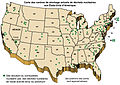
 Image-Census-2000-Data-Top-US-Ancestries-by-County fr FR.png 3,766 × 2,820; 837 KB
-
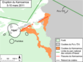 Kamoamoa map-fr.png 1,253 × 930; 185 KB
-
 Kamoamoa map-fr.svg 1,253 × 930; 72 KB
-

-
 Louisiane Français 2021.png 9,727 × 8,864; 6.07 MB
-
 Map of Indians Texas 1500.png 2,308 × 1,584; 521 KB
-
 Map of USA with state names fr.svg 959 × 593; 267 KB
-
 Mormons 2010.png 8,450 × 12,317; 2.87 MB
-
 Mt st helens cendres.png 820 × 578; 110 KB
-
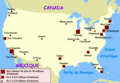
 Nuclear waste locations USA-fr.jpg 1,935 × 1,370; 360 KB
-
 Carte de la Pensylvanie et du Nouveau Jersey (NYPL b15070722-433717).jpg 4,704 × 2,935; 3.46 MB
-
 Carte de la Pensylvanie et du Nouveau Jersey (NYPL b15346084-433617).jpg 4,479 × 2,633; 2.25 MB
-

-

-
 Pais des Illinois.jpg 780 × 570; 363 KB
-
 Plan de la base de Kodiak.svg 4,647 × 5,054; 3.55 MB
-

-

-
-
 Population speaking French at home in New England, sum by county.svg 487 × 467; 1.78 MB
-
 Position du camp de l'armée combinée a Philipsburg du 6 juillet au 19 aoust. LOC gm71000986.jpg 12,676 × 5,216; 6.97 MB
-
 Position du camp de l'armée combinée a Philipsburg du 6 juillet au 19 aoust. LOC gm71000986.tif 12,676 × 5,216; 189.17 MB
-
 Province de New-York en 4 feuilles, LOC 74692642.jpg 11,794 × 17,650; 33.21 MB
-
 Rigobert-Bonne-Atlas-de-toutes-les-parties-connues-du-globe-terrestre MG 0029.tif 5,190 × 3,504; 52.06 MB
-
 South bay fr.png 1,183 × 1,109; 84 KB
-

-
 Verne-Hetzel-Testament exentrique-305.jpg 3,616 × 2,594; 3.25 MB
-
 Ville de Manathe ou Nouvelle-Yorc. NYPL434561.tiff 4,714 × 4,976; 67.12 MB
-
 Tillemon & Coronelli Nouveau Mexique 1687 UTA.jpg 2,908 × 2,244; 6.4 MB
-
 États Unis (6094175502).jpg 2,000 × 1,684; 3.48 MB


_-_Geographicus_-_TheatredelaGeurre-briondelatour-1777.jpg)

_-_Geographicus_-_EtatsUnis-duvotenay-1852.jpg)

_par_H._Vattemare._(With_illustrations.)%27_(11129205285).jpg)


.jpg)
.jpg)
.jpg)


.jpg)
.jpg)


.jpg)
.jpg)
.jpg)


.jpg)


.jpg)


.jpg)
_(14774316051).jpg)