Category:Fosse Delloye
Jump to navigation
Jump to search
| Object location | | View all coordinates using: OpenStreetMap |
|---|
|
This building is classé au titre des monuments historiques de la France. It is indexed in the base Mérimée, a database of architectural heritage maintained by the French Ministry of Culture, under the reference PA59000171
|

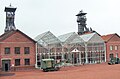
| Centre historique minier, Lewarde
|
|||
|---|---|---|---|
.JPG) |
|||
| Native name | Fosse Joseph Delloye | ||
| Parent institution | northern French coal mining region | ||
| Location | |||
| Coordinates | | ||
| Established | 1984 | ||
| Website | chm-lewarde.com | ||
| Authority file | |||
Français : La fosse Delloye de la Compagnie des mines d'Aniche, actuel Centre historique minier de Lewarde, était un charbonnage du bassin minier du Nord-Pas-de-Calais constitué de deux puits situé à Lewarde, Nord, Nord-Pas-de-Calais, France. Elle est classée aux monuments historiques le 21 septembre 2010 et inscrite sur la liste du patrimoine mondial par l'Unesco le 30 juin 2012 et y constitue le site no 23.
Subcategories
This category has the following 13 subcategories, out of 13 total.
Pages in category "Fosse Delloye"
This category contains only the following page.
Media in category "Fosse Delloye"
The following 200 files are in this category, out of 614 total.
(previous page) (next page)-
 Carreau de fosse et bâtiments de surface CHM Lewarde.JPG 4,608 × 3,456; 4.93 MB
-
 Centre historique minier de Lewarde (1).jpg 2,304 × 3,456; 1.96 MB
-
 Centre historique minier de Lewarde (2).jpg 2,304 × 3,456; 2.01 MB
-
 Centre historique minier de Lewarde (3).jpg 3,456 × 2,304; 2.16 MB
-
 Centre Historique Minier de Lewarde, vu de Erchin en 2020.jpg 4,896 × 1,904; 5.85 MB
-
 Chevalement 1 et 2 de la fosse Delloye à Lewarde en 2014.jpg 4,000 × 1,774; 4.75 MB
-
 Chevalement 1 et 2 de la fosse Delloye à Lewarde.JPG 4,000 × 3,000; 3.08 MB
-
 Coal mine in France (1).jpg 2,542 × 1,674; 1.24 MB
-
 Coal mine in France (2).jpg 2,608 × 1,952; 1.33 MB
-
 La historia mineja centro Lewarde 01.jpg 2,336 × 4,160; 3.59 MB
-
 La historia mineja centro Lewarde 02.jpg 2,336 × 4,160; 2.92 MB
-
 La historia mineja centro Lewarde 03.jpg 4,160 × 2,336; 3.58 MB
-
 La historia mineja centro Lewarde 04.jpg 2,336 × 4,160; 3.44 MB
-
 La historia mineja centro Lewarde 05.jpg 2,336 × 4,160; 3.6 MB
-
 La historia mineja centro Lewarde 06.jpg 4,160 × 2,336; 3.58 MB
-
 La historia mineja centro Lewarde 07.jpg 2,336 × 4,160; 4.41 MB
-
 La historia mineja centro Lewarde 08.jpg 4,160 × 2,336; 3.04 MB
-
 La historia mineja centro Lewarde 09.jpg 4,160 × 2,336; 3.17 MB
-
 La historia mineja centro Lewarde 10.jpg 4,160 × 2,336; 3.05 MB
-
 La historia mineja centro Lewarde 11.jpg 2,336 × 4,160; 3.13 MB
-
 La historia mineja centro Lewarde 12.jpg 4,160 × 2,336; 4.05 MB
-
 La historia mineja centro Lewarde 13.jpg 2,336 × 4,160; 3.93 MB
-
 La historia mineja centro Lewarde 14.jpg 2,336 × 4,160; 2.99 MB
-
 La historia mineja centro Lewarde 15.jpg 2,336 × 4,160; 3.04 MB
-
 La historia mineja centro Lewarde 16.jpg 2,336 × 4,160; 3.89 MB
-
 La historia mineja centro Lewarde 17.jpg 4,160 × 2,336; 3.49 MB
-
 La historia mineja centro Lewarde 18.jpg 4,160 × 2,336; 2.45 MB
-
 La historia mineja centro Lewarde 19.jpg 4,160 × 2,336; 3.8 MB
-
 La historia mineja centro Lewarde 20.jpg 2,336 × 4,160; 3.88 MB
-
 La historia mineja centro Lewarde 21.jpg 2,336 × 4,160; 3.77 MB
-
 La historia mineja centro Lewarde 22.jpg 2,336 × 4,160; 3.64 MB
-
 La historia mineja centro Lewarde 23.jpg 2,336 × 4,160; 2.47 MB
-
 La historia mineja centro Lewarde 24.jpg 2,336 × 4,160; 3.45 MB
-
 La historia mineja centro Lewarde 25.jpg 2,336 × 4,160; 3.23 MB
-
 La historia mineja centro Lewarde 26.jpg 2,336 × 4,160; 2.24 MB
-
 La historia mineja centro Lewarde 27.jpg 2,336 × 4,160; 2.25 MB
-
 La historia mineja centro Lewarde 28.jpg 2,336 × 4,160; 3.69 MB
-
 La historia mineja centro Lewarde 29.jpg 2,336 × 4,160; 3.86 MB
-
 La historia mineja centro Lewarde 30.jpg 4,160 × 2,336; 3.94 MB
-
 La historia mineja centro Lewarde 31.jpg 2,336 × 4,160; 3.48 MB
-
 La historia mineja centro Lewarde 32.jpg 4,160 × 2,336; 3.66 MB
-
 La historia mineja centro Lewarde 33.jpg 2,336 × 4,160; 3.04 MB
-
 La historia mineja centro Lewarde 34.jpg 4,160 × 2,336; 3.15 MB
-
 La historia mineja centro Lewarde 35.jpg 2,336 × 4,160; 2.34 MB
-
 La historia mineja centro Lewarde 36.jpg 2,336 × 4,160; 3.54 MB
-
 La historia mineja centro Lewarde 37.jpg 2,336 × 4,160; 3.61 MB
-
 La historia mineja centro Lewarde 38.jpg 4,160 × 2,336; 2.75 MB
-
 La historia mineja centro Lewarde 39.jpg 4,160 × 2,336; 2.8 MB
-
 La historia mineja centro Lewarde 40.jpg 2,336 × 4,160; 3.95 MB
-
 La historia mineja centro Lewarde 41.jpg 2,336 × 4,160; 3.34 MB
-
 La historia mineja centro Lewarde 42.jpg 2,336 × 4,160; 2.24 MB
-
 La historia mineja centro Lewarde 43.jpg 2,336 × 4,160; 3.09 MB
-
 La historia mineja centro Lewarde 44.jpg 2,336 × 4,160; 4.28 MB
-
 La historia mineja centro Lewarde 45.jpg 2,336 × 4,160; 3.91 MB
-
 La historia mineja centro Lewarde 46.jpg 2,336 × 4,160; 2.49 MB
-
 La historia mineja centro Lewarde 47.jpg 4,160 × 2,336; 3.02 MB
-
 La historia mineja centro Lewarde 48.jpg 2,336 × 4,160; 2.82 MB
-
 La historia mineja centro Lewarde 49.jpg 2,336 × 4,160; 3.56 MB
-
 La historia mineja centro Lewarde 50.jpg 4,160 × 2,336; 3.12 MB
-
 La historia mineja centro Lewarde 51.jpg 2,336 × 4,160; 2.19 MB
-
 La historia mineja centro Lewarde 52.jpg 4,160 × 2,336; 3.81 MB
-
 La historia mineja centro Lewarde 53.jpg 2,336 × 4,160; 3.14 MB
-
 La historia mineja centro Lewarde 54.jpg 4,160 × 2,336; 2.82 MB
-
 La historia mineja centro Lewarde 55.jpg 4,160 × 2,336; 2.55 MB
-
 La historia mineja centro Lewarde 56.jpg 2,336 × 4,160; 2.79 MB
-
 La historia mineja centro Lewarde 57.jpg 2,336 × 4,160; 2.62 MB
-
 La historia mineja centro Lewarde 58.jpg 4,160 × 2,336; 2.02 MB
-
 La historia mineja centro Lewarde 59.jpg 4,160 × 2,336; 3.16 MB
-
 La historia mineja centro Lewarde 60.jpg 2,336 × 4,160; 2.47 MB
-
 La historia mineja centro Lewarde 61.jpg 2,336 × 4,160; 2.62 MB
-
 La historia mineja centro Lewarde 62.jpg 2,336 × 4,160; 3.36 MB
-
 La historia mineja centro Lewarde 63.jpg 2,336 × 4,160; 3.1 MB
-
 La historia mineja centro Lewarde 64.jpg 2,336 × 4,160; 2.09 MB
-
 La historia mineja centro Lewarde 65.jpg 2,336 × 4,160; 3.28 MB
-
 La historia mineja centro Lewarde 66.jpg 4,160 × 2,336; 4.13 MB
-
 La historia mineja centro Lewarde 67.jpg 4,160 × 2,336; 3.41 MB
-
 La historia mineja centro Lewarde 68.jpg 4,160 × 2,336; 3.45 MB
-
 La historia mineja centro Lewarde 69.jpg 2,336 × 4,160; 3.73 MB
-
 La historia mineja centro Lewarde 70.jpg 2,336 × 4,160; 2.64 MB
-
 La historia mineja centro Lewarde 71.jpg 2,336 × 4,160; 3.95 MB
-
 La historia mineja centro Lewarde 72.jpg 2,336 × 4,160; 3.73 MB
-
 La historia mineja centro Lewarde 73.jpg 2,336 × 4,160; 3.11 MB
-
 Lewarde - Fosse Delloye des mines d'Aniche (001).JPG 3,648 × 2,736; 4.21 MB
-
 Lewarde - Fosse Delloye des mines d'Aniche (002).JPG 3,648 × 2,736; 3.93 MB
-
 Lewarde - Fosse Delloye des mines d'Aniche (003).JPG 2,736 × 3,648; 3.14 MB
-
 Lewarde - Fosse Delloye des mines d'Aniche (004).JPG 2,736 × 3,648; 3.02 MB
-
 Lewarde - Fosse Delloye des mines d'Aniche (005).JPG 2,736 × 3,648; 2.83 MB
-
 Lewarde - Fosse Delloye des mines d'Aniche (006).JPG 3,648 × 2,736; 3.58 MB
-
 Lewarde - Fosse Delloye des mines d'Aniche (007).JPG 2,736 × 3,648; 3.04 MB
-
 Lewarde - Fosse Delloye des mines d'Aniche (008).JPG 3,648 × 2,736; 3.67 MB
-
 Lewarde - Fosse Delloye des mines d'Aniche (009).JPG 3,648 × 2,736; 3.33 MB
-
 Lewarde - Fosse Delloye des mines d'Aniche (010).JPG 3,648 × 2,736; 3.93 MB
-
 Lewarde - Fosse Delloye des mines d'Aniche (011).JPG 3,648 × 2,736; 3.61 MB
-
 Lewarde - Fosse Delloye des mines d'Aniche (012).JPG 3,648 × 2,736; 3.63 MB
-
 Lewarde - Fosse Delloye des mines d'Aniche (013).JPG 3,648 × 2,736; 3.65 MB
-
 Lewarde - Fosse Delloye des mines d'Aniche (014).JPG 2,736 × 3,648; 2.97 MB
-
 Lewarde - Fosse Delloye des mines d'Aniche (015).JPG 3,648 × 2,736; 3.58 MB
-
 Lewarde - Fosse Delloye des mines d'Aniche (016).JPG 3,648 × 2,736; 3.66 MB
-
 Lewarde - Fosse Delloye des mines d'Aniche (017).JPG 3,648 × 2,736; 3.47 MB
-
 Lewarde - Fosse Delloye des mines d'Aniche (018).JPG 3,648 × 2,736; 3.73 MB
-
 Lewarde - Fosse Delloye des mines d'Aniche (019).JPG 3,648 × 2,736; 3.87 MB
-
 Lewarde - Fosse Delloye des mines d'Aniche (020).JPG 3,648 × 2,736; 3.79 MB
-
 Lewarde - Fosse Delloye des mines d'Aniche (021).JPG 3,648 × 2,736; 3.6 MB
-
 Lewarde - Fosse Delloye des mines d'Aniche (022).JPG 3,648 × 2,736; 3.7 MB
-
 Lewarde - Fosse Delloye des mines d'Aniche (023).JPG 3,648 × 2,736; 3.67 MB
-
 Lewarde - Fosse Delloye des mines d'Aniche (024).JPG 3,648 × 2,736; 3.53 MB
-
 Lewarde - Fosse Delloye des mines d'Aniche (025).JPG 3,648 × 2,736; 3.46 MB
-
 Lewarde - Fosse Delloye des mines d'Aniche (026).JPG 3,648 × 2,736; 3.91 MB
-
 Lewarde - Fosse Delloye des mines d'Aniche (027).JPG 3,648 × 2,736; 3.59 MB
-
 Lewarde - Fosse Delloye des mines d'Aniche (028).JPG 3,648 × 2,736; 3.71 MB
-
 Lewarde - Fosse Delloye des mines d'Aniche (029).JPG 3,648 × 2,736; 3.5 MB
-
 Lewarde - Fosse Delloye des mines d'Aniche (030).JPG 2,736 × 3,648; 2.61 MB
-
 Lewarde - Fosse Delloye des mines d'Aniche (031).JPG 3,648 × 2,736; 3.57 MB
-
 Lewarde - Fosse Delloye des mines d'Aniche (032).JPG 3,648 × 2,736; 3.08 MB
-
 Lewarde - Fosse Delloye des mines d'Aniche (033).JPG 3,648 × 2,736; 3.53 MB
-
 Lewarde - Fosse Delloye des mines d'Aniche (034).JPG 3,648 × 2,736; 3.56 MB
-
 Lewarde - Fosse Delloye des mines d'Aniche (035).JPG 2,736 × 3,648; 2.94 MB
-
 Lewarde - Fosse Delloye des mines d'Aniche (036).JPG 3,648 × 2,736; 4.07 MB
-
 Lewarde - Fosse Delloye des mines d'Aniche (037).JPG 2,736 × 3,648; 3.3 MB
-
 Lewarde - Fosse Delloye des mines d'Aniche (038).JPG 3,648 × 2,736; 3.73 MB
-
 Lewarde - Fosse Delloye des mines d'Aniche (039).JPG 2,736 × 3,648; 3.1 MB
-
 Lewarde - Fosse Delloye des mines d'Aniche (040).JPG 3,648 × 2,736; 3.87 MB
-
 Lewarde - Fosse Delloye des mines d'Aniche (041).JPG 3,648 × 2,736; 3.77 MB
-
 Lewarde - Fosse Delloye des mines d'Aniche (042).JPG 2,736 × 3,648; 2.97 MB
-
 Lewarde - Fosse Delloye des mines d'Aniche (043).JPG 2,736 × 3,648; 2.97 MB
-
 Lewarde - Fosse Delloye des mines d'Aniche (044).JPG 2,736 × 3,648; 3.02 MB
-
 Lewarde - Fosse Delloye des mines d'Aniche (045).JPG 3,648 × 2,736; 3.99 MB
-
 Lewarde - Fosse Delloye des mines d'Aniche (046).JPG 3,648 × 2,736; 4.12 MB
-
 Lewarde - Fosse Delloye des mines d'Aniche (047).JPG 3,648 × 2,736; 4.06 MB
-
 Lewarde - Fosse Delloye des mines d'Aniche (048).JPG 3,648 × 2,736; 3.49 MB
-
 Lewarde - Fosse Delloye des mines d'Aniche (049).JPG 2,736 × 3,648; 3.01 MB
-
 Lewarde - Fosse Delloye des mines d'Aniche (050).JPG 2,736 × 3,648; 3.24 MB
-
 Lewarde - Fosse Delloye des mines d'Aniche (051).JPG 3,648 × 2,736; 3.65 MB
-
 Lewarde - Fosse Delloye des mines d'Aniche (052).JPG 3,648 × 2,736; 3.91 MB
-
 Lewarde - Fosse Delloye des mines d'Aniche (053).JPG 2,736 × 3,648; 3.31 MB
-
 Lewarde - Fosse Delloye des mines d'Aniche (054).JPG 3,648 × 2,736; 3.95 MB
-
 Lewarde - Fosse Delloye des mines d'Aniche (055).JPG 2,736 × 3,648; 3.2 MB
-
 Lewarde - Fosse Delloye des mines d'Aniche (056).JPG 2,736 × 3,648; 3.52 MB
-
 Lewarde - Fosse Delloye des mines d'Aniche (057).JPG 4,912 × 1,080; 2.92 MB
-
 Lewarde - Fosse Delloye des mines d'Aniche (058).JPG 3,648 × 2,736; 4.36 MB
-
 Lewarde - Fosse Delloye des mines d'Aniche (059).JPG 2,736 × 3,648; 3.53 MB
-
 Lewarde - Fosse Delloye des mines d'Aniche (060).JPG 2,736 × 3,648; 3.52 MB
-
 Lewarde - Fosse Delloye des mines d'Aniche (061).JPG 2,736 × 3,648; 3.44 MB
-
 Lewarde - Fosse Delloye des mines d'Aniche (062).JPG 3,648 × 2,736; 4.15 MB
-
 Lewarde - Fosse Delloye des mines d'Aniche (063).JPG 2,736 × 3,648; 2.96 MB
-
 Lewarde - Fosse Delloye des mines d'Aniche (064).JPG 3,648 × 2,736; 4.24 MB
-
 Lewarde - Fosse Delloye des mines d'Aniche (068).JPG 3,648 × 2,736; 3.46 MB
-
 Lewarde - Fosse Delloye des mines d'Aniche (069).JPG 3,648 × 2,736; 3.42 MB
-
 Lewarde - Fosse Delloye des mines d'Aniche (070).JPG 3,648 × 2,736; 4.1 MB
-
 Lewarde - Fosse Delloye des mines d'Aniche (071).JPG 3,648 × 2,736; 3.53 MB
-
 Lewarde - Fosse Delloye des mines d'Aniche (072).JPG 2,736 × 3,648; 2.64 MB
-
 Lewarde - Fosse Delloye des mines d'Aniche (073).JPG 2,736 × 3,648; 2.74 MB
-
 Lewarde - Fosse Delloye des mines d'Aniche (074).JPG 3,648 × 2,736; 3.71 MB
-
 Lewarde - Fosse Delloye des mines d'Aniche (075).JPG 3,648 × 2,736; 4.23 MB
-
 Lewarde - Fosse Delloye des mines d'Aniche (076).JPG 2,736 × 3,648; 3.43 MB
-
 Lewarde - Fosse Delloye des mines d'Aniche (077).JPG 3,648 × 2,736; 4.23 MB
-
 Lewarde - Fosse Delloye des mines d'Aniche (078).JPG 2,736 × 3,648; 3.42 MB
-
 Lewarde - Fosse Delloye des mines d'Aniche (079).JPG 2,736 × 3,648; 3.59 MB
-
 Lewarde - Fosse Delloye des mines d'Aniche (080).JPG 2,736 × 3,648; 3.39 MB
-
 Lewarde - Fosse Delloye des mines d'Aniche (081).JPG 3,648 × 2,736; 4.16 MB
-
 Lewarde - Fosse Delloye des mines d'Aniche (082).JPG 3,648 × 2,736; 3.83 MB
-
 Lewarde - Fosse Delloye des mines d'Aniche (083).JPG 3,648 × 2,736; 4.09 MB
-
 Lewarde - Fosse Delloye des mines d'Aniche (084).JPG 3,648 × 2,736; 4.09 MB
-
 Lewarde - Fosse Delloye des mines d'Aniche (085).JPG 3,648 × 2,736; 3.89 MB
-
 Lewarde - Fosse Delloye des mines d'Aniche (086).JPG 3,648 × 2,736; 3.94 MB
-
 Lewarde - Fosse Delloye des mines d'Aniche (087).JPG 2,736 × 3,648; 3.26 MB
-
 Lewarde - Fosse Delloye des mines d'Aniche (088).JPG 2,736 × 3,648; 3.16 MB
-
 Lewarde - Fosse Delloye des mines d'Aniche (089).JPG 3,648 × 2,736; 4.07 MB
-
 Lewarde - Fosse Delloye des mines d'Aniche (090).JPG 3,648 × 2,736; 4 MB
-
 Lewarde - Fosse Delloye des mines d'Aniche (091).JPG 3,648 × 2,736; 3.82 MB
-
 Lewarde - Fosse Delloye des mines d'Aniche (092).JPG 3,648 × 2,736; 3.67 MB
-
 Lewarde - Fosse Delloye des mines d'Aniche (093).JPG 2,736 × 3,648; 3.22 MB
-
 Lewarde - Fosse Delloye des mines d'Aniche (094).JPG 3,648 × 2,736; 3.82 MB
-
 Lewarde - Fosse Delloye des mines d'Aniche (095).JPG 3,648 × 2,736; 4.02 MB
-
 Lewarde - Fosse Delloye des mines d'Aniche (096).JPG 3,648 × 2,736; 3.75 MB
-
 Lewarde - Fosse Delloye des mines d'Aniche (097).JPG 3,648 × 2,736; 3.82 MB
-
 Lewarde - Fosse Delloye des mines d'Aniche (098).JPG 3,648 × 2,736; 3.68 MB
-
 Lewarde - Fosse Delloye des mines d'Aniche (099).JPG 3,648 × 2,736; 3.85 MB
-
 Lewarde - Fosse Delloye des mines d'Aniche (100).JPG 2,736 × 3,648; 3.46 MB
-
 Lewarde - Fosse Delloye des mines d'Aniche (101).JPG 3,648 × 2,736; 3.69 MB
-
 Lewarde - Fosse Delloye des mines d'Aniche (102).JPG 3,648 × 2,736; 3.85 MB
-
 Lewarde - Fosse Delloye des mines d'Aniche (103).JPG 2,736 × 3,648; 3.21 MB
-
 Lewarde - Fosse Delloye des mines d'Aniche (104).JPG 2,736 × 3,648; 3.13 MB
-
 Lewarde - Fosse Delloye des mines d'Aniche (105).JPG 2,736 × 3,648; 3.23 MB
-
 Lewarde - Fosse Delloye des mines d'Aniche (106).JPG 2,736 × 3,648; 3.3 MB
-
 Lewarde - Fosse Delloye des mines d'Aniche (107).JPG 3,648 × 2,736; 3.94 MB
-
 Lewarde - Fosse Delloye des mines d'Aniche (108).JPG 2,736 × 3,648; 3.09 MB
-
 Lewarde - Fosse Delloye des mines d'Aniche (109).JPG 2,736 × 3,648; 3.34 MB
-
 Lewarde - Fosse Delloye des mines d'Aniche (110).JPG 3,648 × 2,736; 3.51 MB
-
 Lewarde - Fosse Delloye des mines d'Aniche (111).JPG 3,648 × 2,736; 4.12 MB
-
 Lewarde - Fosse Delloye des mines d'Aniche (112).JPG 3,648 × 2,736; 3.6 MB
-
 Lewarde - Fosse Delloye des mines d'Aniche (113).JPG 3,648 × 2,736; 3.05 MB
-
 Lewarde - Fosse Delloye des mines d'Aniche (114).JPG 3,648 × 2,736; 3.31 MB
-
 Lewarde - Fosse Delloye des mines d'Aniche (115).JPG 3,648 × 2,736; 3.46 MB
-
 Lewarde - Fosse Delloye des mines d'Aniche (116).JPG 2,736 × 3,648; 2.87 MB
-
 Lewarde - Fosse Delloye des mines d'Aniche (117).JPG 3,648 × 2,736; 3.41 MB
-
 Lewarde - Fosse Delloye des mines d'Aniche (118).JPG 3,648 × 2,736; 3.45 MB
-
 Lewarde - Fosse Delloye des mines d'Aniche (119).JPG 2,736 × 3,648; 3.01 MB
-
 Lewarde - Fosse Delloye des mines d'Aniche (120).JPG 3,648 × 2,736; 3.5 MB
-
 Lewarde - Fosse Delloye des mines d'Aniche (121).JPG 2,736 × 3,648; 3.02 MB

.jpg)
.jpg)
.jpg)


.jpg)
.jpg)


.JPG)
.JPG)
.JPG)
.JPG)
.JPG)
.JPG)
.JPG)
.JPG)
.JPG)
.JPG)
.JPG)
.JPG)
.JPG)
.JPG)
.JPG)
.JPG)
.JPG)
.JPG)
.JPG)
.JPG)
.JPG)
.JPG)
.JPG)
.JPG)
.JPG)
.JPG)
.JPG)
.JPG)
.JPG)
.JPG)
.JPG)
.JPG)
.JPG)
.JPG)
.JPG)
.JPG)
.JPG)
.JPG)
.JPG)
.JPG)
.JPG)
.JPG)
.JPG)
.JPG)
.JPG)
.JPG)
.JPG)
.JPG)
.JPG)
.JPG)
.JPG)
.JPG)
.JPG)
.JPG)
.JPG)
.JPG)
.JPG)
.JPG)
.JPG)
.JPG)
.JPG)
.JPG)
.JPG)
.JPG)
.JPG)
.JPG)
.JPG)
.JPG)
.JPG)
.JPG)
.JPG)
.JPG)
.JPG)
.JPG)
.JPG)
.JPG)
.JPG)
.JPG)
.JPG)
.JPG)
.JPG)
.JPG)
.JPG)
.JPG)
.JPG)
.JPG)
.JPG)
.JPG)
.JPG)
.JPG)
.JPG)
.JPG)
.JPG)
.JPG)
.JPG)
.JPG)
.JPG)
.JPG)
.JPG)
.JPG)
.JPG)
.JPG)
.JPG)
.JPG)
.JPG)
.JPG)
.JPG)
.JPG)
.JPG)
.JPG)
.JPG)
.JPG)
.JPG)
.JPG)
.JPG)
.JPG)
.JPG)
.JPG)