Category:Fortified church in Cața
Jump to navigation
Jump to search
Deutsch: Kirchenburg Katzendorf
Magyar: Kacai erődtemplom
| This is a category about a historic monument in județul Brașov, classified with number BV-II-a-A-11628. |
| Object location | | View all coordinates using: OpenStreetMap |
|---|
heritage site in Braşov County, Romania _-_Kirchenburg.jpg) | |||||
| Upload media | |||||
| Instance of |
| ||||
|---|---|---|---|---|---|
| Location |
| ||||
| Street address |
| ||||
| Heritage designation | |||||
 | |||||
Media in category "Fortified church in Cața"
The following 83 files are in this category, out of 83 total.
-
 Altarul bisericii evanghelice din Cata.jpg 2,448 × 3,236; 1.95 MB
-
 Biserica fortificata din Cata.svg 3,329 × 2,602; 249 KB
-
 Cata - amvonul.jpg 2,141 × 3,264; 1.9 MB
-
 Cata - casa parohiala.jpg 3,264 × 1,920; 1.63 MB
-
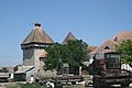
 Cata - fortificatia.jpg 2,441 × 2,854; 1.69 MB
-
 Cata - nava spre altar.jpg 3,264 × 2,448; 1.76 MB
-
 Cata - nava spre iesire.jpg 3,264 × 2,448; 1.94 MB
-
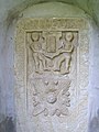 Cata - placa funerara.jpg 2,448 × 3,264; 2.16 MB
-
 Cata - scoala confesionala.jpg 3,264 × 2,161; 2.24 MB
-
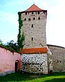
 Cata - turn de aparare.jpg 2,448 × 3,242; 2.28 MB
-
 Cata biserica medievala.jpg 3,888 × 2,592; 3.92 MB
-
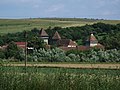
 Cața - biserica evanghelică fortificată..jpg 2,000 × 1,018; 1.88 MB
-
 Cața - fortificația.jpg 2,448 × 3,095; 2.09 MB
-
 Color, Biserica fortificata din Cata.jpg 2,025 × 1,446; 1.07 MB
-
 Katzendorf (Caţa) - Kirchenburg.jpg 2,540 × 1,908; 3.37 MB
-
 Planul fortificatiei din Cata.jpg 357 × 368; 83 KB
-
 RO BV Biserica evanghelica din Cata (1).jpg 3,264 × 2,163; 1.7 MB
-
 RO BV Biserica evanghelica din Cata (10).jpg 3,264 × 2,448; 2.77 MB
-
 RO BV Biserica evanghelica din Cata (11).jpg 2,448 × 3,264; 2.08 MB
-
 RO BV Biserica evanghelica din Cata (12).jpg 2,448 × 3,264; 2.29 MB
-
 RO BV Biserica evanghelica din Cata (13).jpg 2,448 × 3,264; 1.93 MB
-
 RO BV Biserica evanghelica din Cata (14).jpg 2,448 × 2,969; 1.87 MB
-
 RO BV Biserica evanghelica din Cata (15).jpg 2,448 × 3,264; 2.12 MB
-
 RO BV Biserica evanghelica din Cata (16).jpg 3,264 × 2,448; 2.03 MB
-
 RO BV Biserica evanghelica din Cata (17).jpg 2,448 × 3,264; 2.06 MB
-
 RO BV Biserica evanghelica din Cata (18).jpg 2,448 × 3,264; 1.84 MB
-
 RO BV Biserica evanghelica din Cata (19).jpg 2,448 × 3,264; 1.77 MB
-
 RO BV Biserica evanghelica din Cata (2).jpg 2,448 × 3,264; 1.86 MB
-
 RO BV Biserica evanghelica din Cata (20).jpg 3,264 × 2,448; 2.2 MB
-
 RO BV Biserica evanghelica din Cata (21).jpg 2,448 × 3,264; 2.48 MB
-
 RO BV Biserica evanghelica din Cata (22).jpg 2,448 × 3,264; 1.91 MB
-
 RO BV Biserica evanghelica din Cata (23).jpg 3,264 × 2,448; 1.98 MB
-
 RO BV Biserica evanghelica din Cata (24).jpg 3,264 × 2,448; 2.47 MB
-
 RO BV Biserica evanghelica din Cata (25).jpg 2,448 × 3,264; 2.2 MB
-
 RO BV Biserica evanghelica din Cata (26).jpg 2,448 × 3,264; 1.88 MB
-
 RO BV Biserica evanghelica din Cata (27).jpg 3,264 × 2,448; 1.8 MB
-
 RO BV Biserica evanghelica din Cata (28).jpg 3,264 × 2,448; 2.23 MB
-
 RO BV Biserica evanghelica din Cata (29).jpg 3,264 × 2,448; 2.43 MB
-
 RO BV Biserica evanghelica din Cata (3).jpg 3,264 × 2,448; 2.28 MB
-
 RO BV Biserica evanghelica din Cata (30).jpg 2,448 × 3,264; 2.04 MB
-
 RO BV Biserica evanghelica din Cata (31).jpg 2,448 × 3,264; 1.95 MB
-
 RO BV Biserica evanghelica din Cata (32).jpg 2,448 × 3,264; 1.73 MB
-
 RO BV Biserica evanghelica din Cata (33).jpg 3,264 × 2,448; 1.75 MB
-
 RO BV Biserica evanghelica din Cata (34).jpg 3,264 × 2,448; 2.17 MB
-
 RO BV Biserica evanghelica din Cata (35).jpg 2,448 × 3,264; 2.09 MB
-
 RO BV Biserica evanghelica din Cata (36).jpg 2,448 × 3,264; 1.78 MB
-
 RO BV Biserica evanghelica din Cata (37).jpg 3,264 × 2,448; 2.14 MB
-
 RO BV Biserica evanghelica din Cata (38).jpg 3,264 × 2,448; 2.2 MB
-
 RO BV Biserica evanghelica din Cata (39).jpg 3,264 × 2,448; 1.93 MB
-
 RO BV Biserica evanghelica din Cata (4).jpg 2,448 × 3,264; 2.06 MB
-
 RO BV Biserica evanghelica din Cata (40).jpg 2,448 × 3,264; 2.3 MB
-
 RO BV Biserica evanghelica din Cata (41).jpg 3,264 × 2,448; 2.13 MB
-
 RO BV Biserica evanghelica din Cata (42).jpg 2,448 × 3,264; 1.7 MB
-
 RO BV Biserica evanghelica din Cata (43).jpg 3,264 × 2,448; 2.15 MB
-
 RO BV Biserica evanghelica din Cata (44).jpg 3,264 × 2,448; 2.25 MB
-
 RO BV Biserica evanghelica din Cata (45).jpg 3,264 × 2,448; 1.89 MB
-
 RO BV Biserica evanghelica din Cata (46).jpg 2,448 × 3,264; 2.01 MB
-
 RO BV Biserica evanghelica din Cata (47).jpg 2,448 × 3,264; 2.2 MB
-
 RO BV Biserica evanghelica din Cata (48).jpg 2,448 × 3,264; 2.16 MB
-
 RO BV Biserica evanghelica din Cata (49).jpg 3,264 × 2,448; 1.89 MB
-
 RO BV Biserica evanghelica din Cata (5).jpg 2,448 × 3,264; 1.9 MB
-
 RO BV Biserica evanghelica din Cata (50).jpg 2,448 × 3,264; 2.06 MB
-
 RO BV Biserica evanghelica din Cata (51).jpg 3,264 × 2,448; 2.02 MB
-
 RO BV Biserica evanghelica din Cata (52).jpg 3,264 × 2,448; 1.86 MB
-
 RO BV Biserica evanghelica din Cata (53).jpg 2,448 × 3,264; 2.03 MB
-
 RO BV Biserica evanghelica din Cata (54).jpg 2,448 × 3,264; 2.11 MB
-
 RO BV Biserica evanghelica din Cata (55).jpg 2,448 × 3,264; 2.06 MB
-
 RO BV Biserica evanghelica din Cata (56).jpg 3,264 × 2,448; 2.25 MB
-
 RO BV Biserica evanghelica din Cata (57).jpg 2,448 × 3,264; 1.81 MB
-
 RO BV Biserica evanghelica din Cata (58).jpg 2,448 × 3,264; 1.9 MB
-
 RO BV Biserica evanghelica din Cata (59).jpg 3,264 × 2,448; 1.84 MB
-
 RO BV Biserica evanghelica din Cata (6).jpg 2,200 × 2,426; 1.57 MB
-
 RO BV Biserica evanghelica din Cata (60).jpg 3,264 × 2,448; 1.95 MB
-
 RO BV Biserica evanghelica din Cata (61).jpg 2,448 × 3,264; 2.22 MB
-
 RO BV Biserica evanghelica din Cata (62).jpg 2,312 × 3,052; 1.87 MB
-
 RO BV Biserica evanghelica din Cata (63).jpg 2,448 × 3,264; 2.21 MB
-
 RO BV Biserica evanghelica din Cata (65).jpg 2,448 × 3,264; 2.32 MB
-
 RO BV Biserica evanghelica din Cata (66).jpg 3,264 × 2,448; 2.23 MB
-
 RO BV Biserica evanghelica din Cata (67).jpg 3,264 × 2,448; 2.4 MB
-
 RO BV Biserica evanghelica din Cata (68).jpg 3,264 × 2,448; 2.63 MB
-
 RO BV Biserica evanghelica din Cata (7).jpg 3,264 × 2,448; 2.42 MB
-
 RO BV Biserica evanghelica din Cata (8).jpg 2,448 × 3,264; 1.84 MB
-
 RO BV Biserica evanghelica din Cata (9).jpg 3,264 × 2,448; 2.39 MB


.jpg)
.jpg)
.jpg)
.jpg)
.jpg)
.jpg)
.jpg)
.jpg)
.jpg)
.jpg)
.jpg)
.jpg)
.jpg)
.jpg)
.jpg)
.jpg)
.jpg)
.jpg)
.jpg)
.jpg)
.jpg)
.jpg)
.jpg)
.jpg)
.jpg)
.jpg)
.jpg)
.jpg)
.jpg)
.jpg)
.jpg)
.jpg)
.jpg)
.jpg)
.jpg)
.jpg)
.jpg)
.jpg)
.jpg)
.jpg)
.jpg)
.jpg)
.jpg)
.jpg)
.jpg)
.jpg)
.jpg)
.jpg)
.jpg)
.jpg)
.jpg)
.jpg)
.jpg)
.jpg)
.jpg)
.jpg)
.jpg)
.jpg)
.jpg)
.jpg)
.jpg)
.jpg)
.jpg)
.jpg)
.jpg)
.jpg)
.jpg)