Category:Former monastery in Bieńkowice
Jump to navigation
Jump to search
| Object location | | View all coordinates using: OpenStreetMap |
|---|
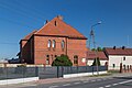
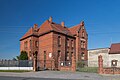
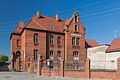
Polski: Budynek dawnego klasztoru - Bieńkowice, ul. Raciborska 17
historic building in Bieńkowice, Silesian Voivodeship, Poland  | |||||
| Upload media | |||||
| Instance of | |||||
|---|---|---|---|---|---|
| Made from material | |||||
| Location | Bieńkowice, Silesian Voivodeship, gmina Krzyżanowice, Racibórz County, Silesian Voivodeship, Poland | ||||
| Street address |
| ||||
| Architectural style | |||||
| Heritage designation |
| ||||
| Elevation above sea level |
| ||||
 | |||||
Media in category "Former monastery in Bieńkowice"
The following 8 files are in this category, out of 8 total.
-
 2022 Powiat raciborski, Bieńkowice, Dawny klasztor 01.jpg 4,922 × 3,281; 8.77 MB
-
 2022 Powiat raciborski, Bieńkowice, Dawny klasztor 02.jpg 4,777 × 3,185; 11.56 MB
-
 2022 Powiat raciborski, Bieńkowice, Dawny klasztor 03.jpg 4,498 × 3,283; 8.72 MB
-
 2022 Powiat raciborski, Bieńkowice, Dawny klasztor 04.jpg 4,460 × 2,973; 6.99 MB
-
 2022 Powiat raciborski, Bieńkowice, Dawny klasztor 05.jpg 4,885 × 3,257; 9.16 MB
-
 2022 Powiat raciborski, Bieńkowice, Dawny klasztor 06.jpg 4,307 × 2,871; 7.39 MB
-
 2022 Powiat raciborski, Bieńkowice, Dawny klasztor 07.jpg 4,911 × 3,274; 10.39 MB
-
 2022 Powiat raciborski, Bieńkowice, Dawny klasztor 08.jpg 4,848 × 3,232; 10.05 MB


