Category:Flugfeld Schaffhausen
Jump to navigation
Jump to search
| Object location | | View all coordinates using: OpenStreetMap |
|---|
Alemannisch: De Flugblatz Schmerlat isch es Sägelfluggländ zwüsche Nüüchirch und Lööninge im Chleggi, Kanton Schaffuuse.
aerodrome in Switzerland  | |||||
| Upload media | |||||
| Instance of | |||||
|---|---|---|---|---|---|
| Named after | |||||
| Location | Schaffhausen, Switzerland | ||||
| Elevation above sea level |
| ||||
| ICAO airport code |
| ||||
| official website | |||||
 | |||||
Subcategories
This category has the following 2 subcategories, out of 2 total.
F
- Fly-in Schaffhausen 2010 (22 F)
Media in category "Flugfeld Schaffhausen"
The following 5 files are in this category, out of 5 total.
-
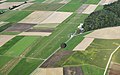 Aerial image of the Schaffhausen airfield.jpg 4,000 × 2,500; 3.96 MB
-
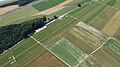
 Flugfeld-schmerlat-2018-01.jpg 3,200 × 2,133; 784 KB
-
 Flugfeld-schmerlat-2018-02.jpg 3,200 × 2,133; 853 KB
-
 Flugfeld-schmerlat-2018-03.jpg 3,200 × 2,133; 977 KB
-
 Schmerlat.jpg 4,608 × 2,592; 2.64 MB


