Category:Fjärestads kyrka
Jump to navigation
Jump to search
| Object location | | View all coordinates using: OpenStreetMap |
|---|
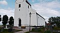
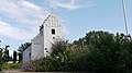
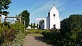
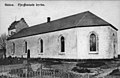
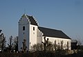
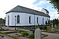
church in Helsingborg municipality, Sweden  | |||||
| Upload media | |||||
| Instance of | |||||
|---|---|---|---|---|---|
| Location | Fjärestad, Scania, Skåne County, Sweden | ||||
| Diocese | |||||
| Has use |
| ||||
| Occupant | |||||
| Heritage designation |
| ||||
| Inception |
| ||||
 | |||||
Svenska: Fjärestads kyrka tillhör Kvistofta församling, Helsingborgs kontrakt, Lunds stift / Diocese of Lund.
|
This is a category about an ecclesiastical monument in Sweden, number 21300000003650 (sub-number: 21400000439914) in the RAÄ buildings database.
|
Subcategories
This category has only the following subcategory.
I
- Interior of Fjärestads kyrka (14 F)
Media in category "Fjärestads kyrka"
The following 30 files are in this category, out of 30 total.
-
 Fjärestad kyrka 1.jpg 4,352 × 2,448; 5.23 MB
-
 Fjärestad kyrka 3.jpg 4,352 × 2,448; 4.97 MB
-
 Fjärestad kyrka 4.jpg 4,352 × 2,448; 6.12 MB
-
 Fjärestad kyrka 5.jpg 4,352 × 2,448; 5.49 MB
-
 Fjärestad kyrka bårhuset.jpg 4,352 × 2,448; 5.24 MB
-
 Fjärestad kyrkogård 1.jpg 4,352 × 2,448; 5.62 MB
-
 Fjärestad kyrkogård 2.jpg 4,352 × 2,448; 5.68 MB
-
 Fjärestad kyrkogård bro.jpg 4,352 × 2,448; 6.27 MB
-
 Fjärestad kyrkogård grönska.jpg 4,352 × 2,448; 6.57 MB
-
 Fjärestad nya kyrkogården.jpg 4,352 × 2,448; 6.39 MB
-
 Fjärestads kyrka - KMB - 16000200052447.jpg 800 × 520; 39 KB
-
 Fjärestads kyrka - KMB - 16000200052448.jpg 800 × 556; 24 KB
-
 Fjärestads kyrka - KMB - 16000200052473.jpg 412 × 600; 13 KB
-
 Fjärestads kyrka - KMB - 16000200052476.jpg 422 × 600; 17 KB
-
 Fjärestads kyrka - KMB - 16000200052477.jpg 417 × 600; 26 KB
-
 Fjärestads kyrka - KMB - 16000200052478.jpg 394 × 600; 20 KB
-
 Fjärestads kyrka - KMB - 16000200052479.jpg 399 × 600; 16 KB
-
 Fjärestads kyrka - KMB - 16000200052480.jpg 826 × 563; 24 KB
-
 Fjärestads kyrka - KMB - 16000200052481.jpg 826 × 561; 34 KB
-
 Fjärestads kyrka - KMB - 16000200052482.jpg 826 × 500; 32 KB
-
 Fjärestads kyrka - KMB - 16000200052485.jpg 826 × 558; 29 KB
-
 Fjärestads kyrka, sedd över Kövlebäcken.jpg 4,352 × 2,448; 6.41 MB
-
 Fjärestads kyrka.jpg 3,006 × 2,050; 4.28 MB
-
 FjärestadsKyrka21500001444117.jpg 3,872 × 2,592; 2.05 MB
-
 FjärestadsKyrka21500001444118.jpg 3,872 × 2,592; 2.29 MB
-
 FjärestadsKyrka21500001444120.jpg 3,872 × 2,592; 2.23 MB
-
 FjärestadsKyrka21500001592187.jpg 2,268 × 1,322; 1 MB
-
 FjärestadsKyrka21500001592188.jpg 2,277 × 1,317; 1.18 MB
-
 FjärestadsKyrka21500001592189.jpg 2,337 × 1,283; 1.32 MB
-
 Swedish History Museum 60.jpg 809 × 1,211; 1.47 MB


