Category:Fisgard Lighthouse
Jump to navigation
Jump to search
| Object location | | View all coordinates using: OpenStreetMap |
|---|
This category is for a cultural heritage site in Canada, number 1146
|
This category is for a cultural heritage site in Canada, number 1253
|
 |
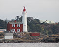
English: Fisgard Lighthouse and its light keeper’s residence comprises a two-storey residence with attached cylindrical light-tower, located on Fisgard Island on the east side of the entrance to Esquimault Harbour, just north of Juan de Fuca Strait.
Français : Le lieu historique national du Canada du Phare-de-Fisgard et la résidence du gardien se compose d'une résidence de deux étages avec un phare cylindrique attenant, situés sur l'île Fisgard, du côté est de l'entrée du port d'Esquimalt, juste au nord du détroit Juan de Fuca.
19th century lighthouse in British Columbia, Canada  | |||||
| Upload media | |||||
| Instance of | |||||
|---|---|---|---|---|---|
| Named after | |||||
| Made from material | |||||
| Location | Colwood, Capital Regional District, British Columbia, Canada | ||||
| Located in or next to body of water | |||||
| Heritage designation | |||||
| Service entry |
| ||||
| Inception |
| ||||
| Significant event |
| ||||
| Height |
| ||||
| official website | |||||
 | |||||
Media in category "Fisgard Lighthouse"
The following 47 files are in this category, out of 47 total.
-
 2Glen tugs2 kgw edit.jpg 2,253 × 1,449; 1.83 MB
-
 2Glen tugs2.jpg 2,862 × 1,866; 2.98 MB
-
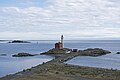
 Aerial photograph of side of Gotha Point.jpg 5,464 × 3,640; 11.62 MB
-
 Cast-iron spiral stairs inside the Fisgard Lighthouse tower.jpg 5,472 × 3,648; 5.36 MB
-
 DGS Malaspina passes Fisgard Lighthouse a-00235 141.jpg 1,000 × 744; 67 KB
-

-
 Fisgard Lighthouse (2007).jpg 1,200 × 800; 131 KB
-
 Fisgard Lighthouse (4699295376).jpg 2,304 × 3,072; 2.38 MB
-
 Fisgard Lighthouse (6930976952).jpg 1,024 × 768; 118 KB
-
 Fisgard Lighthouse (8890651203).jpg 4,380 × 2,905; 5.69 MB
-
 Fisgard Lighthouse (8894061553).jpg 2,912 × 4,368; 1.82 MB
-
 Fisgard Lighthouse (8894679284).jpg 2,912 × 4,368; 2.08 MB
-
 Fisgard Lighthouse - Colwood BC.jpg 1,024 × 633; 146 KB
-
 Fisgard Lighthouse - panoramio.jpg 2,816 × 2,112; 2.51 MB
-
 Fisgard Lighthouse 1.jpg 3,738 × 5,700; 10.01 MB
-
 Fisgard Lighthouse 2.jpg 6,000 × 4,000; 12.55 MB
-
 Fisgard Lighthouse 3.jpg 6,000 × 4,000; 12.39 MB
-
 Fisgard Lighthouse 4.jpg 4,000 × 6,000; 12.26 MB
-
 Fisgard Lighthouse at Fort Rodd Hill.jpg 4,608 × 3,072; 3.84 MB
-
 Fisgard Lighthouse by Vicki McKay - SCAN0386.jpg 1,149 × 1,738; 338 KB
-
 Fisgard Lighthouse Colwood, B.C..JPG 800 × 534; 256 KB
-
 Fisgard lighthouse fort rodd sam gusway.JPG 4,698 × 2,754; 6.72 MB
-
 Fisgard Lighthouse from the lower battery of Fort Rodd Hill.jpg 6,000 × 4,000; 11.86 MB
-
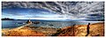
 Fisgard lighthouse looking out into the Strait of Juan de Fuca.jpg 1,600 × 1,068; 1.37 MB
-
 Fisgard Lighthouse National Historic Site August 2011.jpg 1,936 × 2,592; 2.11 MB
-
 Fisgard Lighthouse National Historic Site Victoria BC.JPG 4,000 × 2,248; 2.44 MB
-
 Fisgard Lighthouse National Historic Site, Victoria BC.JPG 4,000 × 2,248; 2.14 MB
-
 Fisgard Lighthouse National Historic Site.jpg 1,536 × 2,048; 413 KB
-
 Fisgard Lighthouse NHS (40742884953).jpg 6,720 × 4,480; 16.88 MB
-
-
 Fisgard lighthouse sam gusway 2.JPG 2,250 × 3,258; 3.57 MB
-
 Fisgard lighthouse sam gusway.JPG 4,134 × 3,276; 6.62 MB
-
 Fisgard Lighthouse, Vancouver Island, BC.jpg 1,280 × 853; 104 KB
-
 Fisgard Lighthouse.jpg 2,592 × 3,872; 1.91 MB
-
 FISHGARD LIGHTHOUSE N.H.S., BRITISH COLUMBIA.jpg 5,143 × 3,575; 1.25 MB
-
 Fort Rodd Hill panorama.jpg 6,672 × 2,388; 6.31 MB
-
 Img 3835 36 37 38 39 40 41 tonemapped-production-1024x768.jpg 1,024 × 683; 179 KB
-
 Light house in Victoria, B.C.jpg 4,752 × 3,168; 1.62 MB
-
 Lighthouse (5039016298).jpg 1,000 × 689; 112 KB
-
 Lighthouse, Victoria, BC.jpg 2,748 × 1,552; 2.61 MB
-
 Lower quality picture of Fisgard Lighthouse (1994).jpg 1,941 × 1,413; 390 KB
-
 Sessional papers of the Dominion of Canada 1903 (1903) (14768130501).jpg 2,976 × 1,884; 799 KB
-
 Victoria fisgard lighthouse.jpg 2,048 × 1,536; 1.05 MB
-
 View of Fisgard lighthouse and island from Fort Rodd hill side.jpg 1,068 × 1,600; 1.62 MB
-
 View of Fisgard lighthouse from direction of the Strait of Juan de Fuca.jpg 1,068 × 1,600; 957 KB
-
 View of Fisgard lighthouse tower from base.jpg 1,600 × 1,068; 1.51 MB
-


.jpg)
.jpg)
.jpg)
.jpg)
.jpg)
.jpg)
.jpg)


.jpg)


.jpg)

.jpg)
_(14768130501).jpg)


Categories:
- National Historic Sites of Canada by name
- Lighthouses in British Columbia
- Lighthouses in Canada by name
- Fort Rodd Hill National Historic Site
- Esquimalt Harbour
- Cultural heritage monuments in Capital Regional District
- Federal Heritage Buildings of Canada in British Columbia
- National Historic Sites of Canada in British Columbia
- Lighthouses designated as National Historic Sites of Canada
- Lighthouses designated as cultural heritage monuments in Canada
- Gothic Revival architecture in British Columbia
- Built in Canada in 1860
- 1860s architecture in British Columbia
- Lighthouses built in 1860
- Brick lighthouses in Canada
- Lighthouses by height, 11 to 20 meters
- White lighthouses in Canada
- Buildings in Colwood, British Columbia
- Harbour entrance lights
- Sector lights
- Classified Federal Heritage Buildings of Canada
- Strait of Juan de Fuca