Category:Feldkirch Domplatz 4
Jump to navigation
Jump to search
| Object location | | View all coordinates using: OpenStreetMap |
|---|
 | |||||
| Upload media | |||||
| Instance of | |||||
|---|---|---|---|---|---|
| Location | Feldkirch, Feldkirch District, Vorarlberg, Austria | ||||
| Street address |
| ||||
| Heritage designation | |||||
 | |||||
Deutsch: Domplatz Nr.4, Bezirkshauptmannschaft in Feldkirch.
Media in category "Feldkirch Domplatz 4"
The following 10 files are in this category, out of 10 total.
-
 Domplatz 4 Bezirkshauptmannschaft, Feldkirch.JPG 4,400 × 3,463; 4.83 MB
-
 Domplatz 4, Feldkirch Bezirkshauptmannschaft 1.JPG 4,475 × 6,900; 10.78 MB
-
 Domplatz 4, Feldkirch Bezirkshauptmannschaft 2.JPG 5,917 × 4,550; 8.01 MB
-
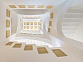 Domplatz 4, Feldkirch Bezirkshauptmannschaft, Stiegenhaus 1.jpg 3,352 × 2,514; 5.34 MB
-
 Domplatz 4, Feldkirch Bezirkshauptmannschaft, Stiegenhaus 2.jpg 7,500 × 11,307; 54.36 MB
-
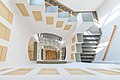
 Domplatz 4, Feldkirch Bezirkshauptmannschaft, Stiegenhaus 3.JPG 7,360 × 4,912; 11.06 MB
-
 Domplatz 4, Feldkirch Bezirkshauptmannschaft, Stiegenhaus 4.jpg 3,330 × 2,220; 3.8 MB
-
 Domplatz 4, Feldkirch.jpg 2,650 × 3,533; 4.19 MB
-
 Feldkirch-Schlossgraben-Bezirkshauptmannschaft-Portal--01ASD.jpg 3,468 × 4,100; 1.12 MB
-
 Schloßgraben 1, BH, Feldkirch.JPG 4,288 × 2,848; 5.88 MB


