Category:Fatimakapelle (Schardenberg)
Jump to navigation
Jump to search
| Object location | | View all coordinates using: OpenStreetMap |
|---|
| This category shows the protected monument with the number 90487 in Austria. (Commons, de, Wikidata) |
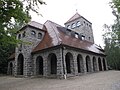
church building in Schardenberg, Austria  _-_Altarraum.jpg) | |||||
| Upload media | |||||
| Instance of | |||||
|---|---|---|---|---|---|
| Named after | |||||
| Location | Schardenberg, Schärding District, Upper Austria, Austria | ||||
| Street address |
| ||||
| Heritage designation | |||||
 | |||||
Media in category "Fatimakapelle (Schardenberg)"
The following 6 files are in this category, out of 6 total.
-
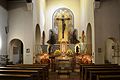 Fatimakapelle (Schardenberg) - Altarraum.jpg 3,000 × 2,000; 3.76 MB
-
 Fatimakapelle (Schardenberg) - innen (1).jpg 3,180 × 1,680; 2.67 MB
-
 Fatimakapelle (Schardenberg) - innen (2).jpg 3,760 × 2,100; 4.02 MB
-
 Fatimakapelle Schardenberg.JPG 1,280 × 960; 498 KB
-
 Schardenberg fatimakapelle .JPG 2,736 × 3,648; 3.64 MB
-
 Schardenberg fatimakapelle.JPG 3,648 × 2,736; 3.5 MB
_-_innen_(1).jpg)
_-_innen_(2).jpg)

