Category:Farmhouse Hohlen 2, Dornbirn
Jump to navigation
Jump to search
| Object location | | View all coordinates using: OpenStreetMap |
|---|
human settlement in Austria  | |||||
| Upload media | |||||
| Instance of | |||||
|---|---|---|---|---|---|
| Location | Dornbirn, Dornbirn District, Vorarlberg, Austria | ||||
| Street address |
| ||||
| Heritage designation | |||||
 | |||||
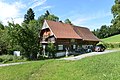
Deutsch: Bauernhof (Anlage) in Hohlen 2, Dornbirn.
Media in category "Farmhouse Hohlen 2, Dornbirn"
The following 3 files are in this category, out of 3 total.
-
 Hohlen 2 Dornbirn, Böhringer 1.JPG 7,360 × 4,912; 9.06 MB
-
 Hohlen 2 Dornbirn, Böhringer 2.JPG 7,360 × 4,912; 9.63 MB
-
 Hohlen 2 Dornbirn, Böhringer 3.JPG 4,912 × 7,360; 6.95 MB

