Category:Falkner Island Light
Jump to navigation
Jump to search
| Object location | | View all coordinates using: OpenStreetMap |
|---|
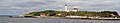
English: Falkner Island Light
lighthouse in Connecticut, United States .jpg) View of Falkner Island and Light | |||||
| Upload media | |||||
| Instance of | |||||
|---|---|---|---|---|---|
| Made from material |
| ||||
| Located in protected area | |||||
| Location | New Haven County, Connecticut | ||||
| Located in or next to body of water | |||||
| Architect |
| ||||
| Operator | |||||
| Heritage designation |
| ||||
| Inception |
| ||||
| Significant event |
| ||||
| Source of energy | |||||
| Height |
| ||||
 | |||||
Media in category "Falkner Island Light"
The following 3 files are in this category, out of 3 total.
-
 Falkner Island research station lighthouse (11800689493).jpg 2,975 × 573; 322 KB
-
 Faulkners IslandLight (New Haven County, Connecticut).jpg 520 × 410; 59 KB
-
 PostcardFalknersIslandLighthouse1904.jpg 550 × 351; 18 KB

.jpg)