Category:Essendine
Jump to navigation
Jump to search
village in the United Kingdom  | |||||
| Upload media | |||||
| Instance of | |||||
|---|---|---|---|---|---|
| Location | Rutland, East Midlands, England | ||||
| Area |
| ||||
 | |||||
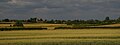
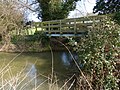
English: Essendine is a village at the eastern end of the county of Rutland in the East Midlands of England. It lies on the West Glen, close by the earthworks of a small castle.
Subcategories
This category has only the following subcategory.
E
Media in category "Essendine"
The following 171 files are in this category, out of 171 total.
-
 'East Coast' rail line near Carlby - geograph.org.uk - 115119.jpg 640 × 480; 54 KB
-
 A hillside plantation - geograph.org.uk - 4333153.jpg 640 × 430; 23 KB
-
 A rectangular plantation - geograph.org.uk - 4333151.jpg 640 × 335; 22 KB
-
 A small rectangular plantation - geograph.org.uk - 4208431.jpg 640 × 430; 54 KB
-
 A straight ditch - geograph.org.uk - 4208430.jpg 640 × 430; 46 KB
-
 A6121 approaching Essendine - geograph.org.uk - 2246237.jpg 800 × 600; 356 KB
-
 A6121 Bourne Road, Essendine - geograph.org.uk - 4211069.jpg 640 × 480; 334 KB
-
 A6121 towards Bourne - geograph.org.uk - 2246247.jpg 800 × 600; 399 KB
-
 A6121, Essendine - geograph.org.uk - 4211071.jpg 640 × 480; 305 KB
-
 B1176 heading south towards Stamford - geograph.org.uk - 3176768.jpg 640 × 480; 67 KB
-
 B1176 towards Stamford - geograph.org.uk - 3176758.jpg 640 × 480; 67 KB
-
 Bourne Road (A6121), Essendine - geograph.org.uk - 4211063.jpg 640 × 480; 260 KB
-
 Brick railway bridge, Essendine, Rutland - geograph.org.uk - 4462300.jpg 4,320 × 3,240; 5.5 MB
-
 Bridge across the East Coast Main Line - geograph.org.uk - 3988497.jpg 1,600 × 1,170; 527 KB
-
 Bridge across the East Coast Main Line - geograph.org.uk - 3988530.jpg 1,600 × 1,175; 455 KB
-
 Bridge across the East Coast Main Line - geograph.org.uk - 3988556.jpg 1,600 × 1,189; 617 KB
-
 Bridge over the East Coast main line near Banthorpe Lodge - geograph.org.uk - 4462522.jpg 4,320 × 3,240; 5.44 MB
-
 Bridge over the railway - geograph.org.uk - 4788692.jpg 5,000 × 3,333; 4.87 MB
-
 Bridleway along the county boundary - geograph.org.uk - 3985802.jpg 1,600 × 1,200; 936 KB
-
 Bridleway along the county boundary - geograph.org.uk - 3991931.jpg 1,600 × 1,062; 501 KB
-
 Carlby across the River West Glen valley - geograph.org.uk - 4714727.jpg 1,600 × 605; 175 KB
-
 Castle or Manor - geograph.org.uk - 4768909.jpg 5,000 × 3,333; 5.17 MB
-
 Castle site - geograph.org.uk - 4768149.jpg 5,000 × 3,333; 6.35 MB
-
 Church and Moat - geograph.org.uk - 4768145.jpg 3,333 × 5,000; 4.87 MB
-
 Church of St Mary, Churchyard and moat - geograph.org.uk - 4768129.jpg 5,000 × 3,333; 6.28 MB
-
 Churchyard moat - geograph.org.uk - 4768911.jpg 5,000 × 3,333; 5.36 MB
-
 Close up of the bridge across the East Coast Main Line - geograph.org.uk - 3988544.jpg 1,600 × 1,297; 196 KB
-

-
 Country view near Banthorpe Lodge - geograph.org.uk - 2445020.jpg 4,000 × 3,000; 4.32 MB
-
 Countryside near Essendine - geograph.org.uk - 4787758.jpg 1,280 × 960; 232 KB
-
 Dedicatory plaque - geograph.org.uk - 5934942.jpg 4,014 × 6,032; 3.47 MB
-
 Defibrillator at the village hall - geograph.org.uk - 5934939.jpg 4,014 × 6,032; 3.55 MB
-
 East Coast main line and bridge - geograph.org.uk - 4462530.jpg 4,320 × 3,240; 6.02 MB
-

-
 East Coast Main Line train in Essendine, Rutland - geograph.org.uk - 4462291.jpg 4,320 × 3,240; 5.56 MB
-

-
 East coast mainline railway - geograph.org.uk - 1745190.jpg 640 × 427; 119 KB
-
 East coast mainline railway - geograph.org.uk - 1745208.jpg 640 × 427; 88 KB
-
 Entrance to the former station site - geograph.org.uk - 4788684.jpg 5,000 × 3,333; 7.07 MB
-
 Essendie main road-Geograph-2246227-by-Jonathan-Billinger.jpg 800 × 601; 331 KB
-
 Essendine railway station (site), Rutland - geograph.org.uk - 3247570.jpg 1,024 × 768; 208 KB
-
 Essendine station site - geograph.org.uk - 4788710.jpg 5,000 × 3,333; 5.68 MB
-
 Essendine Village Hall - geograph.org.uk - 5934937.jpg 6,032 × 4,014; 4.13 MB
-
 Essendine, Bourne Road - geograph.org.uk - 4211065.jpg 640 × 480; 276 KB
-

-
 Factory in Essadine - geograph.org.uk - 4208432.jpg 640 × 372; 43 KB
-
 Farm track - geograph.org.uk - 2488182.jpg 640 × 480; 63 KB
-
 Farm track to Park Farm - geograph.org.uk - 3992263.jpg 1,600 × 1,172; 538 KB
-
 Farm track to Park Farm - geograph.org.uk - 4009269.jpg 1,600 × 1,167; 376 KB
-
 Farmland and lane - geograph.org.uk - 3991944.jpg 1,600 × 1,260; 612 KB
-
 Farmland by ECML - geograph.org.uk - 4208436.jpg 640 × 342; 33 KB
-
 Farmland near Banthorpe Wood - geograph.org.uk - 3989920.jpg 1,600 × 1,233; 596 KB
-
 Farmland near Essendine - geograph.org.uk - 1745166.jpg 640 × 427; 97 KB
-
 Farmland near Essendine - geograph.org.uk - 2486352.jpg 640 × 480; 77 KB
-
 Farmland near Essendine - geograph.org.uk - 3020339.jpg 640 × 485; 51 KB
-
 Farmland near Essendine - geograph.org.uk - 3176763.jpg 640 × 480; 97 KB
-
 Farmland near Essendine - geograph.org.uk - 4544973.jpg 4,000 × 3,000; 4.14 MB
-
 Farmland near Essendine - geograph.org.uk - 4544976.jpg 4,000 × 3,000; 4.14 MB
-
 Farmland near the East Coast Main Line - geograph.org.uk - 3989798.jpg 1,600 × 1,234; 606 KB
-
 Farmland near the West Glen River - geograph.org.uk - 3989865.jpg 1,600 × 1,083; 527 KB
-
 Farmland, North Lodge Farm - geograph.org.uk - 3020343.jpg 800 × 519; 107 KB
-
 Field drain - geograph.org.uk - 4333157.jpg 640 × 370; 35 KB
-
 Fields and plantations east of Essendine - geograph.org.uk - 4714713.jpg 1,600 × 786; 146 KB
-
 Fields and plantations east of Essendine - geograph.org.uk - 4714715.jpg 1,600 × 987; 274 KB
-
 Fingerpost near Belmesthorpe - geograph.org.uk - 4787750.jpg 1,280 × 960; 351 KB
-
 Footbridge across the West Glen River - geograph.org.uk - 3985454.jpg 1,600 × 1,200; 793 KB
-
 Footbridge and ford - West Glen River - geograph.org.uk - 4462572.jpg 4,320 × 3,240; 5.69 MB
-
 Ford - No motor vehicles allowed - geograph.org.uk - 4462565.jpg 4,320 × 3,240; 5.87 MB
-
 Ford across the West Glen River - geograph.org.uk - 3985457.jpg 1,600 × 1,281; 636 KB
-
 Ford at Belmesthorpe - geograph.org.uk - 3809987.jpg 3,264 × 2,448; 4.25 MB
-
 Ford crossing West Glen River - geograph.org.uk - 4460837.jpg 4,320 × 3,240; 5.4 MB
-
 Ford on the West Glen River at Essendine (geograph 2015933).jpg 3,872 × 2,592; 2.25 MB
-
 Former Essendine Goods Yard (Geograph 2010339 by Ashley Dace).jpg 800 × 531; 127 KB
-
 Former pub by the railway in Essendine, Rutland - geograph.org.uk - 4462249.jpg 4,320 × 3,240; 5.46 MB
-
 Former public house - geograph.org.uk - 4788717.jpg 5,000 × 3,333; 5.31 MB
-
 Former railway houses - geograph.org.uk - 4788714.jpg 5,000 × 3,333; 6.23 MB
-
 Formerly The Essendine - geograph.org.uk - 4130604.jpg 640 × 480; 72 KB
-
 Gate and lane near Heath Farm - geograph.org.uk - 3992994.jpg 1,600 × 1,159; 633 KB
-
 Gate and simple fence - geograph.org.uk - 2239763.jpg 800 × 600; 376 KB
-
 Gate and track near North Lodge Farm, Ryhall - geograph.org.uk - 4462213.jpg 4,320 × 3,240; 5.23 MB
-
 Grand Central HST on the East Coast Main Line - geograph.org.uk - 3988515.jpg 1,600 × 1,232; 560 KB
-
 Grange Farm Cottage and Braceborough Grange - geograph.org.uk - 3992127.jpg 1,600 × 1,127; 469 KB
-
 Heading north along the bridleway - geograph.org.uk - 3989781.jpg 1,600 × 1,200; 459 KB
-
 Heading north along the bridleway - geograph.org.uk - 3989949.jpg 1,600 × 1,139; 515 KB
-
 House in Station Road - geograph.org.uk - 4788719.jpg 5,000 × 3,333; 4.96 MB
-
 Lane on the county border - geograph.org.uk - 4462207.jpg 4,320 × 3,240; 5.48 MB
-
 Lane past Crossroads Spinney - geograph.org.uk - 3993038.jpg 1,600 × 1,074; 711 KB
-
 Lane to Essendine and Stamford Road - geograph.org.uk - 3992917.jpg 1,600 × 1,200; 429 KB
-
 Lane to the A6121 and the village of Carlby - geograph.org.uk - 3992199.jpg 1,600 × 1,148; 648 KB
-
 Large cropfield by the ECML - geograph.org.uk - 2403294.jpg 640 × 300; 18 KB
-

-
 Level crossing on the East Coast Main Line - geograph.org.uk - 3988526.jpg 1,400 × 1,215; 665 KB
-

-
 Manorial Earthworks Essendine - geograph.org.uk - 132470.jpg 640 × 427; 148 KB
-
 Minor road north-east of Ryhall - geograph.org.uk - 6212887.jpg 3,776 × 2,520; 3.96 MB
-
 Moat and trees - geograph.org.uk - 4768908.jpg 3,333 × 5,000; 7.17 MB
-
 Moat around churchyard - geograph.org.uk - 4768905.jpg 5,000 × 3,333; 5.51 MB
-
 Moated mound - geograph.org.uk - 4768148.jpg 5,000 × 3,333; 5.65 MB
-
 New Village Green - geograph.org.uk - 4788723.jpg 6,447 × 3,327; 7.6 MB
-
 Office block - geograph.org.uk - 4788683.jpg 5,000 × 3,333; 5.87 MB
-
 Oilseed rape near Carlby, Lincolnshire - geograph.org.uk - 4462453.jpg 4,320 × 3,240; 5.55 MB
-
 Old in new, near Essendine - geograph.org.uk - 114625.jpg 640 × 480; 79 KB
-
 Plover Road, Essendine - geograph.org.uk - 4130627.jpg 640 × 480; 65 KB
-
 Prairie landscape - geograph.org.uk - 4208424.jpg 640 × 430; 53 KB
-
 Public Bridleway - geograph.org.uk - 2488193.jpg 640 × 480; 75 KB
-
 Public bridleway along the county boundary - geograph.org.uk - 3992164.jpg 1,306 × 1,600; 492 KB
-
 Public bridleway along the county boundary - geograph.org.uk - 4009283.jpg 1,600 × 1,196; 545 KB
-
 Public bridleway approaching a small patch of woodland - geograph.org.uk - 3989892.jpg 1,600 × 1,076; 501 KB
-

-
 Public bridleway near the East Coast Main Line - geograph.org.uk - 3988553.jpg 1,600 × 1,187; 496 KB
-
 Railway bridge notice - geograph.org.uk - 4788698.jpg 4,917 × 3,520; 5.72 MB
-
 Road bridge across the West Glen River - geograph.org.uk - 3992751.jpg 1,600 × 1,242; 403 KB
-
 Road Junction - geograph.org.uk - 2488177.jpg 640 × 480; 108 KB
-
 Road junction and finger post - geograph.org.uk - 5510391.jpg 640 × 480; 62 KB
-
 Road junction and finger post - geograph.org.uk - 5510394.jpg 640 × 467; 36 KB
-
 Road junction and grass triangle - geograph.org.uk - 5131207.jpg 3,648 × 2,736; 2.65 MB
-
 Road junction with grass triangle - geograph.org.uk - 5496210.jpg 4,032 × 2,268; 2.19 MB
-
 Road junction with grass triangle - geograph.org.uk - 5496265.jpg 4,032 × 2,268; 2.05 MB
-
 Road north-west of North Lodge Farm - geograph.org.uk - 6212884.jpg 3,776 × 2,520; 4.11 MB
-
 Road to Essendine - geograph.org.uk - 1745124.jpg 640 × 427; 111 KB
-
 Road to Essendine - geograph.org.uk - 2482691.jpg 640 × 480; 66 KB
-
 Road to Uffington - geograph.org.uk - 2239773.jpg 800 × 600; 414 KB
-
 Rolling landscape near Essendine - geograph.org.uk - 2482667.jpg 640 × 480; 58 KB
-
 Rural Bridleway - geograph.org.uk - 2488186.jpg 640 × 480; 68 KB
-
 Rutland oak - geograph.org.uk - 2246195.jpg 800 × 600; 385 KB
-
 Rutland on the right, Lincolnshire on the left. - geograph.org.uk - 4462332.jpg 4,320 × 3,240; 5.5 MB
-
 Sign on Essendine bridge - geograph.org.uk - 1745198.jpg 640 × 427; 101 KB
-
 Site of former station - geograph.org.uk - 4788705.jpg 4,000 × 2,958; 6.41 MB
-
 South Lincolnshire farmland - geograph.org.uk - 4333160.jpg 640 × 430; 29 KB
-
 South Lincolnshire Scenery - geograph.org.uk - 4333156.jpg 640 × 430; 20 KB
-
 St.Stephen's church from the train - geograph.org.uk - 2010341.jpg 800 × 531; 85 KB
-
 Stamford road bridge - geograph.org.uk - 4788702.jpg 5,000 × 3,333; 7.43 MB
-
 Stamford Storage, Essendine - geograph.org.uk - 4333145.jpg 640 × 321; 25 KB
-
 Station road, Essendine - geograph.org.uk - 4788688.jpg 5,000 × 3,333; 5.8 MB
-
 The B1176 heading north from Ryhall - geograph.org.uk - 5670712.jpg 3,776 × 2,520; 3.58 MB
-
 The Drift heading west - geograph.org.uk - 3176765.jpg 480 × 640; 67 KB
-
 The Drift joining the B1176 - geograph.org.uk - 5670698.jpg 3,776 × 2,520; 2.73 MB
-
 The Freewards - geograph.org.uk - 1043986.jpg 640 × 427; 118 KB
-
 The Freewards - geograph.org.uk - 2482655.jpg 640 × 480; 101 KB
-
 The lane to the village of Carlby - geograph.org.uk - 3993049.jpg 1,600 × 1,200; 774 KB
-
 The Metals - geograph.org.uk - 4788696.jpg 5,000 × 3,333; 6.96 MB
-
 The site of Essendine station - geograph.org.uk - 6306490.jpg 1,024 × 683; 331 KB
-
 Track to disused pit - geograph.org.uk - 2239751.jpg 800 × 600; 364 KB
-
 Train on the East Coast Main Line - geograph.org.uk - 3989856.jpg 1,600 × 1,392; 447 KB
-
 Tree on the county boundary - geograph.org.uk - 3989960.jpg 1,600 × 1,248; 771 KB
-
 Triple triangles - geograph.org.uk - 5131216.jpg 3,648 × 2,736; 2.49 MB
-

-

-

-

-
 View south east along the East Coast Main Line - geograph.org.uk - 3988540.jpg 1,600 × 1,288; 630 KB
-
 View towards an unnamed plantation - geograph.org.uk - 6266102.jpg 1,024 × 768; 120 KB
-
 View towards Park Farm in Rutland - geograph.org.uk - 3989939.jpg 1,600 × 1,200; 517 KB
-
 Virgin East Coast Main Line train - geograph.org.uk - 4462186.jpg 4,320 × 3,240; 6.04 MB
-
 Welcome to Lincolnshire - geograph.org.uk - 2246242.jpg 800 × 600; 349 KB
-
 West Glen River (geograph 2486371).jpg 640 × 480; 76 KB
-
 West Glen River and ford - geograph.org.uk - 4462553.jpg 4,320 × 3,240; 5.71 MB
-
 West Glen River and ford in Essendine, Rutland - geograph.org.uk - 4462304.jpg 4,320 × 3,240; 5.6 MB
-
 West Glen River near Carlby - geograph.org.uk - 4545235.jpg 4,000 × 3,000; 4.31 MB
-
 West Glen valley floor - geograph.org.uk - 2246234.jpg 800 × 600; 414 KB
-
 Woodland near Essendine - geograph.org.uk - 2403301.jpg 640 × 291; 21 KB
-
 Woodland near Manor Farm - geograph.org.uk - 4333142.jpg 640 × 430; 31 KB
-
 Woodland on the edge of Essendine - geograph.org.uk - 2367584.jpg 640 × 356; 22 KB
-

-
 B1176 looking north near Essendine - geograph.org.uk - 350816.jpg 640 × 480; 139 KB
-
 East Coast Mainline running South - geograph.org.uk - 355667.jpg 640 × 480; 103 KB
-
 Edinburgh this way - geograph.org.uk - 487346.jpg 640 × 477; 116 KB
-
 Keep out of TF0512 - geograph.org.uk - 115128.jpg 640 × 480; 83 KB
-
 Railway bridge - geograph.org.uk - 127561.jpg 640 × 427; 114 KB
-

-
 Valley - geograph.org.uk - 127559.jpg 640 × 427; 93 KB


,_Essendine_-_geograph.org.uk_-_4211063.jpg)


,_Rutland_-_geograph.org.uk_-_3247570.jpg)


.jpg)
.jpg)


.jpg)


