Category:Esker near Gatschow (Germany)
Jump to navigation
Jump to search
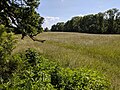
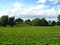
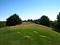
English: Esker in Mecklenburg-Western Pomerania; the Esker illustrated here runs in northnortheast - southsouthwest direction of Gatschow in the north to Varchentin in the south in the district Mecklenburgische Seenplatte and is the longest, more or less coherent Esker in Northeast-Germany.
Deutsch: Os in Mecklenburg-Vorpommern; das hier abgebildete Os verläuft in Nordnordost-Südsüdwest-Richtung von Gatschow im Norden bis Varchentin im Landkreis Mecklenburgische Seenplatte und ist das längste, mehr oder weniger zusammenhängende Os Nordostdeutschlands. Es verläuft im nördlichen Teil parallel zur glazialen Rinne, bzw. an deren oberem Westrand, die heute das Stromtal des Augrabens bildet.
| Object location | | View all coordinates using: OpenStreetMap |
|---|
Media in category "Esker near Gatschow (Germany)"
The following 19 files are in this category, out of 19 total.
-
 Os Gatschow-Varchentin - 2023-06-05 a.jpg 4,048 × 3,036; 6.71 MB
-
 Os Gatschow-Varchentin - 2023-06-05 b.jpg 4,048 × 3,036; 5.1 MB
-
 Os-26-VIII-2007-22.jpg 1,020 × 624; 106 KB
-
 Os-26-VIII-2007-23.jpg 1,024 × 768; 523 KB
-
 Os-bei-Gatschow-27-07-2008-051.jpg 1,024 × 768; 437 KB
-
 Os-bei-Gatschow-27-07-2008-055.jpg 1,024 × 768; 496 KB
-
 Os-bei-Gatschow-27-07-2008-057.jpg 1,024 × 768; 709 KB
-
 Os-bei-Gatschow-27-07-2008-063.jpg 1,024 × 768; 543 KB
-
 Os-bei-Gatschow-27-07-2008-069.jpg 1,024 × 768; 548 KB
-
 Os-bei-Gatschow-27-07-2008-072.jpg 2,272 × 1,704; 2.55 MB
-
 Os-bei-Gatschow-27-07-2008-078.jpg 2,272 × 1,704; 1.91 MB
-
 Os-bei-Gatschow-27-07-2008-082.jpg 1,024 × 768; 631 KB
-
 Os-bei-Gatschow-27-07-2008-083.jpg 1,024 × 768; 516 KB
-
 Os-bei-Gatschow-27-07-2008-147.jpg 1,024 × 768; 570 KB
-
 Os-bei-Gatschow-27-07-2008-149.jpg 1,024 × 768; 543 KB
-
 Os-bei-Gatschow-27-07-2008-160.jpg 1,024 × 768; 638 KB
-
 Os-bei-Gatschow-27-07-2008-202.jpg 1,024 × 768; 457 KB
-
 Os-bei-Gatschow-27-07-2008-247.jpg 2,272 × 1,704; 2.77 MB
-
 Os-bei-Gatschow-27-07-2008-249.jpg 1,024 × 768; 614 KB


