Category:Enka Ede
Jump to navigation
Jump to search
| Object location | | View all coordinates using: OpenStreetMap |
|---|
 | |||||
| Upload media | |||||
| Instance of | |||||
|---|---|---|---|---|---|
| Part of | |||||
| Location | Ede, Gelderland, Netherlands | ||||
| Street address |
| ||||
| Heritage designation |
| ||||
 | |||||
|
This is a category about rijksmonumentcomplex number 527062
|
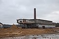
Fabrieksschoorsteen
|
This is a category about rijksmonument number 527063
|
Kunstzijdefabriek
|
This is a category about rijksmonument number 527064
|
Fabrieksschoorsteen
|
This is a category about rijksmonument number 527065
|
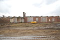
Fabrieksgebouw
|
This is a category about rijksmonument number 527066
|
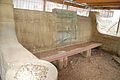
HERINNERINGSBANK
|
This is a category about rijksmonument number 527067
|
Gedenkteken
|
This is a category about rijksmonument number 527068
|
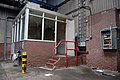
Gebouw geneeskundige dienst
|
This is a category about rijksmonument number 527069
|
Was-, kleed- en schaftlokal
|
This is a category about rijksmonument number 527070
|
| Address |
|
Media in category "Enka Ede"
The following 87 files are in this category, out of 87 total.
-
 20191125Hartogsweg. Ede.jpg 2,657 × 1,726; 1.24 MB
-
 Defietser.jpg 1,453 × 816; 223 KB
-
 Ede Enka Historische fabrieksmuur.jpg 4,491 × 1,776; 2.81 MB
-
 Ede Enka Poort.jpg 4,160 × 2,512; 3.5 MB
-
 Ede, Netherlands - panoramio (10).jpg 2,048 × 1,375; 269 KB
-
 Ede, Netherlands - panoramio (11).jpg 2,048 × 1,375; 309 KB
-
 Ede, Netherlands - panoramio (49).jpg 2,048 × 1,155; 842 KB
-
 Ede, Netherlands - panoramio (5).jpg 2,048 × 1,375; 402 KB
-
 Ede, Netherlands - panoramio (6).jpg 2,048 × 1,375; 326 KB
-
 Ede, Netherlands - panoramio (7).jpg 2,048 × 1,375; 300 KB
-
 Ede, Netherlands - panoramio (8).jpg 2,048 × 1,375; 342 KB
-
 Ede, Netherlands - panoramio (9).jpg 2,048 × 1,375; 297 KB
-
 Ede, Netherlands - panoramio - Ben Bender (1).jpg 4,032 × 3,024; 1.8 MB
-
 Ede, Netherlands - panoramio - Ben Bender (10).jpg 4,032 × 3,024; 1.56 MB
-
 Ede, Netherlands - panoramio - Ben Bender (11).jpg 4,032 × 3,024; 1.92 MB
-
 Ede, Netherlands - panoramio - Ben Bender (12).jpg 4,032 × 3,024; 1.71 MB
-
 Ede, Netherlands - panoramio - Ben Bender (13).jpg 4,032 × 3,024; 2.54 MB
-
 Ede, Netherlands - panoramio - Ben Bender (14).jpg 4,032 × 3,024; 1.55 MB
-
 Ede, Netherlands - panoramio - Ben Bender (15).jpg 4,032 × 3,024; 1.28 MB
-
 Ede, Netherlands - panoramio - Ben Bender (16).jpg 4,032 × 3,024; 1.3 MB
-
 Ede, Netherlands - panoramio - Ben Bender (17).jpg 4,032 × 3,024; 1.24 MB
-
 Ede, Netherlands - panoramio - Ben Bender (18).jpg 3,024 × 4,032; 1.37 MB
-
 Ede, Netherlands - panoramio - Ben Bender (19).jpg 4,032 × 3,024; 1.21 MB
-
 Ede, Netherlands - panoramio - Ben Bender (4).jpg 4,032 × 3,024; 1.81 MB
-
 Ede, Netherlands - panoramio - Ben Bender (5).jpg 4,032 × 3,024; 1.85 MB
-
 Ede, Netherlands - panoramio - Ben Bender (6).jpg 4,032 × 3,024; 1.79 MB
-
 Ede, Netherlands - panoramio - Ben Bender (7).jpg 4,032 × 3,024; 2.6 MB
-
 Ede, Netherlands - panoramio - Ben Bender (8).jpg 4,032 × 3,024; 2.32 MB
-
 Ede, Netherlands - panoramio - Ben Bender (9).jpg 4,032 × 3,024; 2.19 MB
-
 Ede, Netherlands - panoramio - Ben Bender.jpg 4,032 × 3,024; 1.89 MB
-
 Ede, Netherlands - panoramio.jpg 4,032 × 3,024; 1.55 MB
-
 ENKA - Ede Wageningen (25840050483).jpg 4,256 × 2,832; 4.77 MB
-
 ENKA - Ede Wageningen (26170038700).jpg 4,256 × 2,832; 3.49 MB
-
 ENKA - Ede Wageningen (26170040610).jpg 4,256 × 2,832; 4.03 MB
-
 ENKA - Ede Wageningen (26442875235).jpg 4,256 × 2,832; 5.92 MB
-
 ENKA - Ede Wageningen (26442876355).jpg 4,256 × 2,832; 5.08 MB
-
 Enka - May 2020 2.jpg 4,000 × 3,000; 5.62 MB
-
 Enka - May 2020 3.jpg 4,000 × 3,000; 6.03 MB
-
 Enka - May 2020.jpg 3,000 × 4,000; 4.23 MB
-
 ENKA bedrijfsschoorsteen.JPG 2,000 × 3,008; 1.61 MB
-
 Enka Ede achterzijde westhal 1.jpg 4,000 × 3,000; 5.52 MB
-
 Enka Ede achterzijde westhal 2.jpg 2,250 × 3,000; 2.67 MB
-
 Enka Ede.jpg 3,008 × 2,000; 3.08 MB
-
 Enka Fabriekschoorsteen 2.JPG 3,008 × 2,000; 2.62 MB
-
 Enka Fabrieksschoorsteen 1927 2.JPG 3,072 × 2,304; 1.26 MB
-
 Enka fabrieksschoorsteen 1927.JPG 2,304 × 3,072; 738 KB
-
 ENKA Fabrieksschoorsteen.JPG 3,008 × 2,000; 2.16 MB
-
 ENKA Fontein.JPG 3,008 × 2,000; 2.73 MB
-
 ENKA gedenkbank.JPG 3,008 × 2,000; 2.63 MB
-
 ENKA Geneeskundiggebouw.JPG 3,008 × 2,000; 2.27 MB
-
 Enka Hal.jpg 3,008 × 2,000; 2.62 MB
-
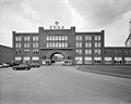
 ENKA Hoofdingang.JPG 3,008 × 2,000; 2.58 MB
-
 Enka kantine gebouw (cropped).jpg 2,385 × 1,415; 1.38 MB
-
 Enka kantine gebouw.jpg 3,008 × 2,000; 2.18 MB
-
 Enka kantoortje.jpg 3,008 × 2,000; 2.74 MB
-
 Enka Main gate.jpg 3,008 × 2,000; 2.54 MB
-
 Enka mozaïek Nijverheidsplein.jpg 4,000 × 2,782; 6.6 MB
-
 Enka poortgebouw.jpg 2,126 × 1,640; 635 KB
-
 Enka westvleugel fabrieksgebouw.JPG 3,072 × 2,304; 1.45 MB
-
 Enka.jpg 758 × 583; 353 KB
-
 Enka01-Bitterzoutmagazijn nr527066.jpg 5,760 × 3,840; 9.28 MB
-
 Enka02-Bitterzoutmagazijn nr527066.jpg 4,165 × 2,977; 9.69 MB
-
 Enkalaan.jpg 3,648 × 2,432; 1.86 MB
-
 Exterieur OVERZICHT VOORGEVEL - Ede - 20313743 - RCE.jpg 1,169 × 1,200; 269 KB
-
 Fabrieksschoorsteen 1922 1.JPG 2,304 × 3,072; 891 KB
-
 Heimanslaan.jpg 3,417 × 2,240; 1.77 MB
-
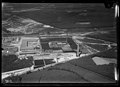
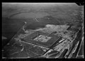 NIMH - 2011 - 0111 - Aerial photograph of Ede, The Netherlands - 1920 - 1940.jpg 3,500 × 2,524; 2.03 MB
-
 NIMH - 2011 - 0112 - Aerial photograph of Ede, The Netherlands - 1920 - 1940.jpg 3,500 × 2,550; 2.19 MB
-
 NIMH - 2011 - 0113 - Aerial photograph of Ede, The Netherlands - 1920 - 1940.jpg 3,500 × 2,508; 1.97 MB
-

-
 NIMH - 2011 - 0114 - Aerial photograph of Ede, The Netherlands - 1920 - 1940.jpg 3,500 × 2,499; 2.03 MB
-
 NIMH - 2011 - 0743 - Aerial photograph of Ede, The Netherlands - 1920 - 1940.jpg 3,500 × 2,557; 2 MB
-
 Nolethof.jpg 2,968 × 2,043; 1.24 MB
-
 Overzicht - Ede - 20313744 - RCE.jpg 1,181 × 1,200; 275 KB
-
 Overzicht voorgevel poortgebouw - Ede - 20359707 - RCE.jpg 1,200 × 956; 205 KB
-
 Scheerboom.jpg 3,415 × 2,112; 2.09 MB
-
 Station Ede Wageningen 2022 1.jpg 4,000 × 2,250; 5.61 MB
-
 Tesselhofflaan.jpg 3,597 × 2,398; 2.5 MB
-
 Uiterwaalhof.jpg 3,648 × 2,432; 2.4 MB
-
 Visserstraat.jpg 3,303 × 1,987; 1.82 MB
-
 Vlashoek.jpg 3,648 × 2,432; 2.72 MB
-

-
 Wederopbouw Ede Enka, Bestanddeelnr 902-4658.jpg 2,720 × 2,722; 1.51 MB
-
 Wederopbouw Ede Enka, Bestanddeelnr 902-4659.jpg 2,720 × 2,722; 1.36 MB
-
 Wederopbouw Ede Enka, Bestanddeelnr 902-4660.jpg 2,720 × 2,722; 1.54 MB
-
 Wederopbouw Ede Enka, Bestanddeelnr 902-4661.jpg 2,720 × 2,722; 1.61 MB
-
 Weefboom.jpg 2,692 × 2,239; 1.81 MB


.jpg)
.jpg)
.jpg)
.jpg)
.jpg)
.jpg)
.jpg)
.jpg)
.jpg)
.jpg)
.jpg)
.jpg)
.jpg)
.jpg)
.jpg)
.jpg)
.jpg)
.jpg)
.jpg)
.jpg)
.jpg)
.jpg)
.jpg)
.jpg)
.jpg)


.jpg)
.jpg)
.jpg)
.jpg)
.jpg)


.jpg)


.jpg)


