Category:Emberton
Jump to navigation
Jump to search
Main Wikipedia article: Emberton.
Norsk bokmål: Emberton er en landsby og et verdslig sogn i Buckinghamshire i England. Den har siden 1995 tilhørt den enhetlige myndigheten Milton Keynes. Landsbyen ligger nær grensen til Northamptonshire, rett sør for Olney og 6 km nord for Newport Pagnell.
village and civil parish in Buckinghamshire, UK  | |||||
| Upload media | |||||
| Instance of | |||||
|---|---|---|---|---|---|
| Location | City of Milton Keynes, Buckinghamshire, South East England, England | ||||
 | |||||
Media in category "Emberton"
The following 87 files are in this category, out of 87 total.
-
 Autumn Berries - geograph.org.uk - 272283.jpg 480 × 640; 130 KB
-
 Bend on the A509 approaching Olney - geograph.org.uk - 5445355.jpg 1,990 × 1,454; 938 KB
-
 Between the Woods - geograph.org.uk - 267449.jpg 640 × 480; 73 KB
-
 Bridge Street (Olney Bridge) - geograph.org.uk - 6305587.jpg 800 × 600; 679 KB
-
 Bridge Street, Olney - geograph.org.uk - 5429704.jpg 2,048 × 1,536; 1.5 MB
-
 Bus shelter on the A509 - geograph.org.uk - 3211844.jpg 1,600 × 1,066; 618 KB
-
 By-passed A509 - geograph.org.uk - 3248441.jpg 3,264 × 2,448; 2.12 MB
-
 Corner of the Snipe Pool - geograph.org.uk - 3219873.jpg 1,600 × 1,067; 646 KB
-
 Cottage in the wood - geograph.org.uk - 3211847.jpg 1,600 × 1,068; 965 KB
-
 Cotton Wool Clouds - geograph.org.uk - 267460.jpg 640 × 328; 35 KB
-
 Countryside Path - geograph.org.uk - 267424.jpg 640 × 480; 137 KB
-
 Cycle path to Olney - geograph.org.uk - 3211841.jpg 1,200 × 1,600; 732 KB
-
 Cycle path to Olney - geograph.org.uk - 3211867.jpg 1,600 × 1,066; 679 KB
-
 Duck and drakes - geograph.org.uk - 5680352.jpg 2,730 × 2,043; 3.48 MB
-
 Electricity pole in field with wind farm behind - geograph.org.uk - 3219914.jpg 1,200 × 1,600; 297 KB
-
 Emberton - geograph.org.uk - 195487.jpg 640 × 446; 118 KB
-
 Emberton Country Park - geograph.org.uk - 5680643.jpg 3,264 × 2,448; 5.68 MB
-
 Emberton High Street near the school - geograph.org.uk - 3211858.jpg 1,600 × 1,068; 646 KB
-
 Emberton Memorial Clock Tower.jpg 3,840 × 5,760; 4.65 MB
-
 Emberton Monument - geograph.org.uk - 3248435.jpg 3,264 × 2,448; 1,017 KB
-
 Emberton wind farm from the air - geograph.org.uk - 3190295.jpg 640 × 480; 116 KB
-
 Emberton wind farm from the air - geograph.org.uk - 3190312.jpg 640 × 480; 110 KB
-
 Emberton, All Saints - geograph.org.uk - 5441444.jpg 4,608 × 3,456; 3.99 MB
-
 Entrance to Emberton Country Park - geograph.org.uk - 3219879.jpg 1,600 × 1,069; 510 KB
-
 Farmland and Woods - geograph.org.uk - 267456.jpg 640 × 480; 82 KB
-
 Farmland Track - geograph.org.uk - 267445.jpg 640 × 480; 124 KB
-
 Farmland View - geograph.org.uk - 272276.jpg 640 × 480; 120 KB
-
 Farmyard - geograph.org.uk - 272275.jpg 640 × 480; 108 KB
-
 Father of the bride - geograph.org.uk - 2729246.jpg 1,944 × 2,592; 2.2 MB
-
 Field with electricity supply - geograph.org.uk - 3219905.jpg 1,600 × 1,067; 333 KB
-
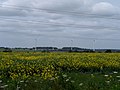
 Foot path through oil seed rape and wind turbines - geograph.org.uk - 3534500.jpg 4,320 × 3,240; 4.52 MB
-
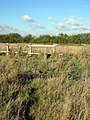
 Footbridge on the path to Grange Farm - geograph.org.uk - 3559782.jpg 1,200 × 1,600; 709 KB
-
 Footpath across the field - geograph.org.uk - 3211861.jpg 1,600 × 1,068; 775 KB
-
 Footpath along the field edge to Olney - geograph.org.uk - 3211862.jpg 1,200 × 1,600; 843 KB
-
 Footpath alongside Short Wood - geograph.org.uk - 3559795.jpg 1,600 × 1,068; 723 KB
-
 Footpath and conservation area by the Seven Acre Covert - geograph.org.uk - 3559757.jpg 1,600 × 1,068; 654 KB
-
 Footpath in Prospect Place - geograph.org.uk - 3211852.jpg 1,200 × 1,600; 740 KB
-
 Footpath to Emberton - geograph.org.uk - 3211856.jpg 1,600 × 1,067; 844 KB
-
 Footpath to Hill Farm - geograph.org.uk - 3211853.jpg 1,600 × 1,068; 744 KB
-
 Footpath to Hill Farm - geograph.org.uk - 3211864.jpg 1,200 × 1,600; 990 KB
-
 Footpath to the Seven Acre Covert - geograph.org.uk - 3559792.jpg 1,600 × 1,068; 736 KB
-
 Footpath towards the Seven Acre Covert - geograph.org.uk - 3559748.jpg 1,600 × 1,067; 651 KB
-
 From the North - geograph.org.uk - 272286.jpg 640 × 248; 22 KB
-
 Gateway at Emberton Country Park - geograph.org.uk - 5680621.jpg 3,264 × 2,448; 5.52 MB
-
 Grebe Lake at Emberton Country Park - geograph.org.uk - 5680349.jpg 3,264 × 2,448; 4.08 MB
-
 Heron Water at Emberton Country Park - geograph.org.uk - 5680622.jpg 3,264 × 2,448; 5.38 MB
-
 Hollington Wood - geograph.org.uk - 250902.jpg 640 × 480; 111 KB
-
 Houses on Wagstaff Way, Olney - geograph.org.uk - 5680615.jpg 3,264 × 2,448; 3.16 MB
-
 Lane through Emberton Country Park - geograph.org.uk - 3219869.jpg 1,600 × 1,069; 719 KB
-
 Large Willow at Emberton Country Park - geograph.org.uk - 5680630.jpg 3,264 × 2,448; 4.35 MB
-
 Looking South - geograph.org.uk - 272287.jpg 640 × 165; 16 KB
-
 New hedgerow planting - geograph.org.uk - 3674790.jpg 1,600 × 1,068; 397 KB
-
 Newport Road, Emberton - geograph.org.uk - 5424681.jpg 1,932 × 1,391; 790 KB
-
 Newport Road, Emberton - geograph.org.uk - 5429712.jpg 2,004 × 1,476; 914 KB
-
 Newport Road, Emberton - geograph.org.uk - 5445354.jpg 2,048 × 1,536; 1.51 MB
-
 Olney Bridge - geograph.org.uk - 6305571.jpg 800 × 600; 732 KB
-
 Ordnance Survey Cut Mark - geograph.org.uk - 3248657.jpg 3,264 × 2,448; 2.47 MB
-
 Ordnance Survey Flush Bracket 1792 - geograph.org.uk - 3250511.jpg 3,264 × 2,448; 1.89 MB
-
 Ordnance Survey Flush Bracket 1793 - geograph.org.uk - 3248643.jpg 3,264 × 2,448; 2.1 MB
-
 Park benches at Grebe Lake - geograph.org.uk - 5680350.jpg 3,264 × 2,448; 4.6 MB
-
 Parrage's Wood and turbine - geograph.org.uk - 3559799.jpg 1,600 × 1,067; 502 KB
-
 Pasture by Petsoe Manor Farm - geograph.org.uk - 3219929.jpg 1,600 × 1,068; 273 KB
-
 Path by Hollington Wood - geograph.org.uk - 3211850.jpg 1,600 × 1,069; 716 KB
-
 Path by the covert towards Olney - geograph.org.uk - 3559766.jpg 1,200 × 1,600; 612 KB
-
 Path through the corner of the covert - geograph.org.uk - 3559761.jpg 1,600 × 1,067; 677 KB
-
 Path to Clifton Pastures - geograph.org.uk - 3219898.jpg 1,200 × 1,600; 646 KB
-
 Path to Rectory Farm - geograph.org.uk - 3211860.jpg 1,600 × 1,069; 775 KB
-
 Path to Short Wood - geograph.org.uk - 3559770.jpg 1,200 × 1,600; 636 KB
-
 Petsoe Manor Farm - geograph.org.uk - 272274.jpg 640 × 480; 112 KB
-
 Petsoe Manor wind farm - geograph.org.uk - 3534466.jpg 4,320 × 3,240; 5.02 MB
-
 Petsoe Manor Windfarm, aerial - geograph.org.uk - 3514426.jpg 640 × 427; 40 KB
-
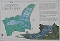 Plan of Emberton Country Park - geograph.org.uk - 5680635.jpg 2,521 × 1,697; 1.33 MB
-
 Poplars at Emberton Country Park - geograph.org.uk - 5680355.jpg 3,264 × 2,448; 5.01 MB
-
 Public Footpath - geograph.org.uk - 3219896.jpg 1,600 × 1,068; 747 KB
-
 Pumping station, Harvey Drive - geograph.org.uk - 4369110.jpg 480 × 640; 103 KB
-
 Road Junction - geograph.org.uk - 246037.jpg 640 × 480; 54 KB
-
 Road junction and grass triangle - geograph.org.uk - 5250845.jpg 800 × 600; 137 KB
-
 Road to Petsoe Manor Farm - geograph.org.uk - 195495.jpg 640 × 480; 75 KB
-
 Seven Acre Covert - geograph.org.uk - 267432.jpg 480 × 640; 129 KB
-
 Short Wood and path - geograph.org.uk - 3559777.jpg 1,600 × 1,069; 641 KB
-
 Sluice on the Great Ouse near Olney - geograph.org.uk - 6305582.jpg 800 × 600; 765 KB
-
 Stile on the path to Emberton - geograph.org.uk - 3211857.jpg 1,200 × 1,600; 766 KB
-
 The dead-end road to Petsoe End - geograph.org.uk - 195491.jpg 640 × 480; 102 KB
-
 The Ouse Valley Way - geograph.org.uk - 5680626.jpg 3,264 × 2,448; 5.03 MB
-
 The track to Wood Farm and Hollington Wood - geograph.org.uk - 3211845.jpg 1,600 × 1,068; 643 KB
-
 Track to Wood Farm by Hollington Wood - geograph.org.uk - 3211849.jpg 1,200 × 1,600; 862 KB
-
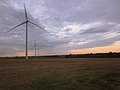 Wind turbines in the stubble - geograph.org.uk - 3674787.jpg 1,600 × 1,200; 202 KB


_-_geograph.org.uk_-_6305587.jpg)


