Category:Election maps of Lancashire
Jump to navigation
Jump to search
This category contains election maps for the ceremonial county of Lancashire.
Media in category "Election maps of Lancashire"
The following 177 files are in this category, out of 177 total.
-
 2000 Hyndburn Borough Council Election Map.png 390 × 486; 10 KB
-
 2019 Pendle Borough Council Election Results Map.png 4,642 × 3,061; 1.01 MB
-
 2021 Burnley election map changes.png 1,838 × 863; 178 KB
-
 2021 Burnley Election Map.png 2,171 × 1,326; 369 KB
-
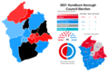 2021 Hyndburn Borough Council Election Results Map.png 3,040 × 2,043; 552 KB
-
 2021 Lancashire County Council Election Results Map.png 3,250 × 1,852; 599 KB
-
 2021 pendle borough council election results map.png 2,388 × 1,708; 386 KB
-
 2022 Burnley Borough Council Election Results Map.png 4,359 × 3,053; 965 KB
-
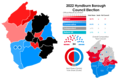 2022 Hyndburn Borough Council Election Results Map.png 3,040 × 2,043; 558 KB
-
 2022 Pendle Borough Council Election Results Map.png 2,983 × 1,902; 542 KB
-
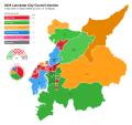 2023 Lancaster City Council Election.svg 850 × 800; 835 KB
-
 2023 Lancaster City Wards.svg 700 × 800; 776 KB
-
 2023 Pendle Borough Council Election Results Map.png 3,142 × 2,016; 575 KB
-
 2023 Ribble Valley Borough Council Election Results Map.png 2,194 × 2,263; 493 KB
-
 2024 Lancashire Police and Crime Commissioner Election.svg 1,116 × 1,305; 444 KB
-
 2024 Pendle Borough Council Election Results Map.png 3,142 × 2,016; 555 KB
-
 Blackburn with Darwen UK ward map 2018.svg 528 × 731; 208 KB
-
 Blackburn with Darwen UK ward map 2019.svg 528 × 731; 206 KB
-
 Blackburn with Darwen UK ward map 2021.svg 528 × 731; 206 KB
-
 Blackburn with Darwen UK ward map 2022.svg 528 × 731; 206 KB
-
 Blackburn with Darwen UK ward map 2023.svg 528 × 731; 206 KB
-
 BLACKBURN-WITH-DARWEN (49910224268).png 2,160 × 1,080; 351 KB
-
 BLACKPOOL (49910743326).png 2,160 × 1,080; 334 KB
-
 Blackpool 2007 election map.png 258 × 480; 34 KB
-
 Blackpool Council election 2011 map.svg 1,079 × 1,305; 197 KB
-
 Blackpool local election 2003 map.svg 1,079 × 1,305; 197 KB
-
 Blackpool local election map 2015.png 800 × 968; 132 KB
-
 Blackpool UK local election 2007 map.svg 1,079 × 1,305; 197 KB
-
 Blackpool UK ward map 2019.svg 1,079 × 1,305; 202 KB
-
 Blackpool UK ward map 2023.svg 1,151 × 1,392; 276 KB
-
 Burnley (42140582845).png 2,192 × 1,432; 118 KB
-
 Burnley Council Election Results Map 2003.svg 1,425 × 1,223; 302 KB
-
 Burnley Council Election Results Map 2010.svg 1,425 × 1,223; 298 KB
-
 Burnley Council Election Results Map 2012.svg 1,425 × 1,223; 296 KB
-
 Burnley Council Election Results Map 2016.svg 1,425 × 1,223; 236 KB
-
 Burnley Council Election Results Map 2018.svg 1,425 × 1,223; 182 KB
-
 Burnley Council Election Results Map 2019.svg 1,425 × 1,223; 296 KB
-
 Burnley Council Election Results Map 2021.svg 1,425 × 1,223; 277 KB
-
 Burnley Council Election Results Map 2022.svg 1,425 × 1,223; 277 KB
-
 Burnley Council Election Results Map 2023.svg 1,425 × 1,223; 277 KB
-
 Burnley Council Election Results Map 2024.svg 1,425 × 1,223; 277 KB
-
 Burnley UK ward map 2010 (blank).svg 1,425 × 1,223; 276 KB
-
 Chorley (42140583355).png 2,068 × 1,468; 130 KB
-
 Chorley 2003.jpg 705 × 600; 190 KB
-
 Chorley 2004.jpg 705 × 600; 190 KB
-
 Chorley 2006.jpg 705 × 600; 206 KB
-
 Chorley 2007.jpg 705 × 600; 206 KB
-
 Chorley 2008.jpg 705 × 600; 201 KB
-
 Chorley 2011.jpg 705 × 600; 63 KB
-
 Chorley 2012.jpg 705 × 600; 64 KB
-
 Chorley 2014.jpg 705 × 600; 200 KB
-
 Chorley UK local election 2006 map.svg 1,425 × 1,212; 498 KB
-
 Chorley UK ward map 2010 (blank).svg 1,425 × 1,212; 498 KB
-
 Fylde 2007 election map.png 591 × 480; 73 KB
-
 Fylde UK local election 2003 map.svg 1,425 × 1,176; 358 KB
-
 Fylde UK local election 2007 map.svg 1,425 × 1,176; 358 KB
-
 Fylde UK local election 2011 map.svg 1,425 × 1,176; 357 KB
-
 Fylde UK local election 2015 map.svg 1,425 × 1,176; 370 KB
-
 Fylde UK local election 2019 map.svg 1,425 × 1,176; 370 KB
-
 HYNDBURN (28373757827).png 1,200 × 1,000; 129 KB
-
 Hyndburn Borough Council 2021 Composition Map.png 2,918 × 1,776; 424 KB
-
 Hyndburn UK local election 2002 map.svg 512 × 507; 357 KB
-
 Hyndburn UK local election 2003 map.svg 512 × 507; 335 KB
-
 Hyndburn UK local election 2004 map.svg 512 × 507; 335 KB
-
 Hyndburn UK local election 2006 map.svg 512 × 507; 335 KB
-
 Hyndburn UK local election 2007 map.svg 512 × 507; 335 KB
-
 Hyndburn UK local election 2008 map.svg 512 × 507; 335 KB
-
 Hyndburn UK local election 2010 map Revised.svg 512 × 507; 335 KB
-
 Hyndburn UK local election 2010 map.svg 512 × 507; 333 KB
-
 Hyndburn UK local election 2011 map.svg 1,319 × 1,305; 235 KB
-
 Hyndburn UK local election 2012 map.svg 512 × 507; 335 KB
-
 Hyndburn UK local election 2014 map (Revised).svg 512 × 507; 335 KB
-
 Hyndburn UK local election 2014 map.svg 512 × 507; 333 KB
-
 Hyndburn UK local election 2015 map.svg 512 × 507; 304 KB
-
 Hyndburn UK local election 2016 map.svg 512 × 507; 335 KB
-
 Hyndburn UK local election 2018 map .png 960 × 952; 69 KB
-
 Hyndburn UK local election 2019 map.png 937 × 926; 137 KB
-
 Hyndburn UK local election 2021 Map.png 1,024 × 1,013; 142 KB
-
 Hyndburn UK local election 2022 map.png 1,451 × 1,436; 200 KB
-
 Hyndburn UK local election 2023 map revised.png 1,451 × 1,436; 213 KB
-
 Hyndburn UK local election 2023 map.png 937 × 926; 165 KB
-
 Hyndburn UK local election 2024 map.svg 512 × 507; 335 KB
-
 Hyndburn UK ward map 2021 (councillors).png 4,542 × 4,498; 789 KB
-
 Lancashire Local Elections 2017.svg 1,395 × 1,631; 2.53 MB
-
 Lancashire Local Elections 2021.svg 1,116 × 1,305; 1.75 MB
-
 Lancashire UK local election 2013 map.svg 1,116 × 1,305; 1.78 MB
-
 Lancashire wards 2005.svg 1,116 × 1,305; 1.78 MB
-
 Lancashire wards 2009.svg 1,116 × 1,305; 1.78 MB
-
 LancashireParliamentaryConstituency1885Results.svg 2,869 × 4,243; 304 KB
-
 LancashireParliamentaryConstituency1886Results.svg 2,869 × 4,243; 304 KB
-
 LancashireParliamentaryConstituency1892Results.svg 2,869 × 4,243; 304 KB
-
 LancashireParliamentaryConstituency1895Results.svg 2,869 × 4,243; 304 KB
-
 LancashireParliamentaryConstituency1900Results.svg 2,869 × 4,243; 304 KB
-
 LancashireParliamentaryConstituency1906Results.svg 2,869 × 4,243; 304 KB
-
 LancashireParliamentaryConstituency1910DResults.svg 2,869 × 4,243; 304 KB
-
 LancashireParliamentaryConstituency1910JResults.svg 2,869 × 4,243; 304 KB
-
 LancashireParliamentaryConstituency1918Results.svg 2,968 × 4,239; 301 KB
-
 LancashireParliamentaryConstituency1922Results.svg 2,968 × 4,239; 301 KB
-
 LancashireParliamentaryConstituency1923Results.svg 2,968 × 4,239; 301 KB
-
 LancashireParliamentaryConstituency1924Results.svg 2,968 × 4,239; 301 KB
-
 LancashireParliamentaryConstituency1929Results.svg 2,968 × 4,239; 301 KB
-
 LancashireParliamentaryConstituency1931Results.svg 2,968 × 4,239; 301 KB
-
 LancashireParliamentaryConstituency1935Results.svg 2,968 × 4,239; 301 KB
-
 LancashireParliamentaryConstituency1945Results.svg 2,967 × 4,238; 316 KB
-
 LancashireParliamentaryConstituency1950Results.svg 1,631 × 2,331; 39 KB
-
 LancashireParliamentaryConstituency1951Results.svg 1,631 × 2,331; 39 KB
-
 LancashireParliamentaryConstituency1955Results.svg 1,638 × 2,327; 38 KB
-
 LancashireParliamentaryConstituency1959Results.svg 1,638 × 2,327; 38 KB
-
 LancashireParliamentaryConstituency1964Results.svg 1,638 × 2,327; 38 KB
-
 LancashireParliamentaryConstituency1966Results.svg 1,638 × 2,327; 38 KB
-
 LancashireParliamentaryConstituency1970Results.svg 1,638 × 2,327; 38 KB
-
 LancashireParliamentaryConstituency1974FResults.svg 1,627 × 2,320; 37 KB
-
 LancashireParliamentaryConstituency1974OResults.svg 1,627 × 2,320; 37 KB
-
 LancashireParliamentaryConstituency1979Results.svg 1,627 × 2,320; 37 KB
-
 LancashireParliamentaryConstituency2005Results2.png 240 × 285; 34 KB
-
 LancashireParliamentaryConstituency2010Results2.png 240 × 299; 37 KB
-
 LancashireParliamentaryConstituency2015Results2.png 240 × 299; 37 KB
-
 Lancaster UK local election 2015 map.svg 1,164 × 1,305; 801 KB
-
 Lancaster UK local election 2019 map.svg 1,164 × 1,305; 801 KB
-
 Lancaster UK ward map 2023.svg 612 × 636; 399 KB
-
 PENDLE (43193615682).png 1,200 × 1,000; 201 KB
-
 Pendle 2006 election map.png 472 × 406; 56 KB
-
 Pendle 2007 election map.png 472 × 406; 49 KB
-
 Pendle 2008 election map.png 472 × 406; 55 KB
-
 Pendle UK local election 2002 map.svg 1,425 × 1,214; 315 KB
-
 Pendle UK local election 2003 map.svg 1,425 × 1,214; 313 KB
-
 Pendle UK local election 2004 map.svg 1,425 × 1,214; 313 KB
-
 Pendle UK local election 2006 map.svg 1,425 × 1,214; 313 KB
-
 Pendle UK local election 2007 map.svg 1,425 × 1,214; 313 KB
-
 Pendle UK local election 2008 map.svg 1,425 × 1,214; 313 KB
-
 Pendle UK local election 2010 map.svg 1,425 × 1,214; 313 KB
-
 Pendle UK local election 2011 map.svg 1,425 × 1,214; 313 KB
-
 Pendle UK local election 2012 map.svg 1,425 × 1,214; 313 KB
-
 Pendle UK local election 2014 map.svg 1,425 × 1,214; 313 KB
-
 Pendle UK local election 2019 map.svg 1,425 × 1,214; 320 KB
-
 PRESTON (28373757447).png 1,200 × 1,000; 209 KB
-
 Preston UK local election 2002 map.svg 1,187 × 1,305; 323 KB
-
 Preston UK local election 2003 map.svg 1,187 × 1,305; 322 KB
-
 Preston UK local election 2004 map.svg 1,187 × 1,305; 322 KB
-
 Preston UK local election 2006 map.svg 1,187 × 1,305; 322 KB
-
 Preston UK local election 2007 map.svg 1,187 × 1,305; 322 KB
-
 Preston UK local election 2008 map.svg 1,187 × 1,305; 322 KB
-
 Preston UK local election 2010 map.svg 1,187 × 1,305; 323 KB
-
 Preston UK ward map 2011.png 1,024 × 1,126; 206 KB
-
 Preston UK ward map 2019.svg 633 × 687; 258 KB
-
 Preston UK ward map 2021.svg 633 × 687; 250 KB
-
 Preston UK ward map 2022.svg 633 × 687; 250 KB
-
 Preston UK ward map 2023.svg 633 × 687; 250 KB
-
 Preston UKlocalelection 2011map.svg 1,187 × 1,305; 322 KB
-
 ROSSENDALE (42524704284).png 1,200 × 1,000; 167 KB
-
 Rossendale local election result.svg 673 × 600; 42 KB
-
 Rossendale UK local election 2012 map.svg 1,385 × 1,306; 279 KB
-
 Rossendale UK local election 2019 map.svg 1,385 × 1,306; 363 KB
-
 Rossendale UK local election 2021 map.svg 1,385 × 1,306; 280 KB
-
 Rossendale UK ward map 2022.svg 1,385 × 1,306; 280 KB
-
 Rossendale UK ward map 2023.svg 1,385 × 1,306; 280 KB
-
 South Ribble 2015 Borough Council Election Ward Map.svg 1,425 × 1,038; 378 KB
-
 South Ribble 2019 Borough Council Election Ward Map.svg 1,425 × 1,038; 378 KB
-
 South Ribble 2023 Borough Council Election.svg 1,425 × 1,038; 517 KB
-
 South Ribble UK local election 2003 map.svg 1,425 × 1,038; 403 KB
-
 South Ribble UK local election 2007 map.svg 1,425 × 1,038; 402 KB
-
 South Ribble UK local election 2011 map.svg 1,425 × 1,038; 402 KB
-
 South Ribble UK ward map 2023.svg 1,425 × 1,038; 378 KB
-
 Stretford 1945.png 931 × 697; 62 KB
-
 Stretford 1946.png 907 × 708; 56 KB
-
 Stretford 1947.png 898 × 695; 56 KB
-
 Stretford 1949.png 927 × 687; 55 KB
-
 W Lanca (42140588365).png 1,312 × 1,060; 92 KB
-
 West Lancashire 2006 election map.png 434 × 480; 60 KB
-
 West Lancashire 2007 election map.png 434 × 480; 57 KB
-
 West Lancashire 2008 election map.png 434 × 480; 64 KB
-
 West Lancashire local election map.svg 542 × 600; 70 KB
-
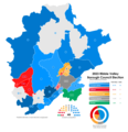
 West Lancashire UK local election 2021 map.svg 1,173 × 1,306; 583 KB
-
 West Lancashire UK ward map 2010 (blank).svg 1,173 × 1,306; 581 KB
-
 West Lancashire UK ward map 2022.svg 1,173 × 1,306; 583 KB
-
 Wyre UK local election 2007 map.svg 1,425 × 981; 525 KB
-
 Wyre UK local election 2011 map.svg 1,425 × 981; 525 KB


.png)
.png)


.png)


.png)


.png)


.svg)


.png)


.png)


.png)


.png)


.png)


.svg)
.svg)
.svg)