Category:Einfriedung Am Linnerhof 10
Jump to navigation
Jump to search
| Object location | | View all coordinates using: OpenStreetMap |
|---|
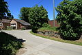
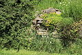
This is the category for an architectural monument.
It is on the list of cultural monuments of Gevelsberg, no. 73.
It is on the list of cultural monuments of Gevelsberg, no. 73.
Media in category "Einfriedung Am Linnerhof 10"
The following 6 files are in this category, out of 6 total.
-
 Gevelsberg Asbeck - Am Linnerhof10 - Mauer 01 ies.jpg 5,616 × 3,744; 7.97 MB
-
 Gevelsberg Asbeck - Am Linnerhof10 - Mauer 02 ies.jpg 5,616 × 3,744; 9.38 MB
-
 Gevelsberg Asbeck - Am Linnerhof10 - Mauer 03 ies.jpg 5,616 × 3,744; 12.14 MB
-
 Gevelsberg Asbeck - Am Linnerhof10 - Mauer 04 ies.jpg 5,616 × 3,744; 19.21 MB
-
 Gevelsberg Asbeck - Am Linnerhof10 - Mauer 05 ies.jpg 5,616 × 3,744; 9.2 MB
-
 Gevelsberg Asbeck - Am Linnerhof10 - Mauer 06 ies.jpg 5,616 × 3,744; 8.59 MB


