Category:Eglise réformée (Route d'Agiez 2.3, Bretonnières)
Jump to navigation
Jump to search
| Object location | | View all coordinates using: OpenStreetMap |
|---|
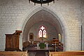
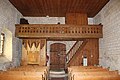
church building in Bretonnières in the canton of Vaud, Switzerland  | |||||
| Upload media | |||||
| Instance of | |||||
|---|---|---|---|---|---|
| Part of | |||||
| Location | |||||
| Street address |
| ||||
| Heritage designation | |||||
 | |||||
Media in category "Eglise réformée (Route d'Agiez 2.3, Bretonnières)"
The following 12 files are in this category, out of 12 total.
-
 Bretonnieres-Kirche.jpg 1,200 × 800; 214 KB
-
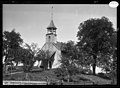 CH-ACV AMH-C-0059.jpg 2,139 × 1,571; 2.14 MB
-
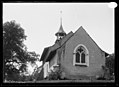 CH-ACV AMH-C-0060.jpg 2,158 × 1,572; 1.68 MB
-
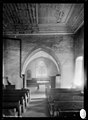 CH-ACV AMH-C-0061.jpg 1,567 × 2,143; 1.44 MB
-

-
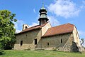 Premier Vaud Temple 1.jpg 5,184 × 3,456; 8.01 MB
-
 Premier Vaud Temple 2.jpg 3,456 × 5,184; 8.86 MB
-
 Premier Vaud Temple 3.jpg 5,184 × 3,456; 7.24 MB
-
 Premier Vaud Temple 4.jpg 5,184 × 3,456; 6.11 MB
-
 Premier Vaud Temple 5.jpg 5,184 × 3,456; 4.2 MB
-
 Premier Vaud Temple 6.jpg 5,184 × 3,456; 7.21 MB
-
 Premier Vaud Temple 7.jpg 5,184 × 3,456; 6.9 MB


