Category:Eglise St-André et cure (Chamoson)
Jump to navigation
Jump to search
| Object location | | View all coordinates using: OpenStreetMap |
|---|
church buildings in Chamoson in the canton of Valais, Switzerland   | |||||
| Upload media | |||||
| Instance of | |||||
|---|---|---|---|---|---|
| Part of | |||||
| Location | Chamoson, Conthey District, Valais, Switzerland | ||||
| Street address |
| ||||
| Heritage designation | |||||
 | |||||
Media in category "Eglise St-André et cure (Chamoson)"
The following 6 files are in this category, out of 6 total.
-
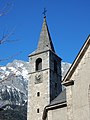 Chamoson, église paroissiale, clocher.jpg 1,200 × 1,600; 427 KB
-
 Chamoson, église paroissiale, décor intérieur, détail.jpg 1,600 × 1,200; 476 KB
-
 Chamoson, église paroissiale, décor intérieur.jpg 1,600 × 1,200; 495 KB
-
 Chamoson, église paroissiale, vue du choeur.jpg 1,600 × 1,200; 466 KB
-
 Chamoson, église paroissiale, vue du sud.jpg 1,600 × 1,200; 444 KB
-
 Chamoson, église paroissiale, vue vers le choeur.jpg 1,600 × 1,200; 461 KB


