Category:East Ardsley
Jump to navigation
Jump to search
village in United Kingdom  | |||||
| Upload media | |||||
| Instance of | |||||
|---|---|---|---|---|---|
| Location | Leeds, West Yorkshire, Yorkshire and the Humber, England | ||||
 | |||||
English: East Ardsley (or Ardsley East) is a village within the City of Leeds metropolitan borough, in West Yorkshire, England. It is situated south of Leeds city centre
Subcategories
This category has the following 11 subcategories, out of 11 total.
A
- Ardsley and Tingley Library (2 F)
B
- The Bay Horse, East Ardsley (3 F)
C
- Carrgate Interchange (13 F)
- Cave Lane, East Ardsley (3 F)
- Common Lane, East Ardsley (4 F)
E
- East Ardsley War Memorial (4 F)
G
- Grange Farm, East Ardsley (4 F)
M
O
- East Ardsley Old Hall (4 F)
W
- Woodhouse Lane, East Ardsley (9 F)
Media in category "East Ardsley"
The following 114 files are in this category, out of 114 total.
-
 Across the field - geograph.org.uk - 906164.jpg 640 × 480; 101 KB
-
 Amblers Mill, East Ardsley. - geograph.org.uk - 119219.jpg 640 × 480; 150 KB
-
 Amblers Mill, East Ardsley. - geograph.org.uk - 58392.jpg 640 × 480; 79 KB
-

-

-
 Ardsley Court - Bluebell Road - geograph.org.uk - 3558411.jpg 640 × 480; 69 KB
-
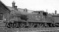 Ardsley Locomotive Depot geograph-2359946-by-Ben-Brooksbank.jpg 2,394 × 1,321; 532 KB
-
 Ardsley Locomotive Depot geograph-2844359-by-Ben-Brooksbank.jpg 2,394 × 1,328; 1.53 MB
-
 Ardsley Reservoir Dam - geograph.org.uk - 838824.jpg 480 × 640; 68 KB
-
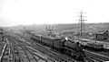
 Ardsley station local goods geograph-2888637-by-Ben-Brooksbank.jpg 2,203 × 1,384; 1.14 MB
-
-
 Ash View - Forsythia Avenue - geograph.org.uk - 3332197.jpg 640 × 480; 71 KB
-

-
 Batley Road at Haigh Moor. - geograph.org.uk - 118703.jpg 640 × 480; 88 KB
-
-
 Bell Tower - geograph.org.uk - 987647.jpg 565 × 640; 49 KB
-
 Bidder Drive - Forest Ridge - geograph.org.uk - 3352154.jpg 640 × 459; 63 KB
-

-
 Blind Lane Farm. - geograph.org.uk - 118712.jpg 640 × 480; 78 KB
-
 Blind Lane towards West Ardsley - geograph.org.uk - 3920693.jpg 1,600 × 1,064; 420 KB
-
 Blue skies turn grey at Ardsley reservoir - geograph.org.uk - 6018865.jpg 2,560 × 1,920; 2.22 MB
-

-
 BP Filling Station - Bradford Road - geograph.org.uk - 669297.jpg 640 × 355; 27 KB
-
 BP garage on the A650, Royston Hill - geograph.org.uk - 3918552.jpg 1,600 × 1,009; 434 KB
-
 Bradford Road - geograph.org.uk - 1857140.jpg 1,600 × 1,200; 440 KB
-

-
 Bradford Road, East Ardsley - geograph.org.uk - 5125028.jpg 1,024 × 682; 177 KB
-
 Bradford Road, East Ardsley - geograph.org.uk - 5125035.jpg 1,024 × 682; 199 KB
-
 Bridge DOL2-20 - Fall Lane - geograph.org.uk - 3204079.jpg 640 × 480; 69 KB
-
 Bridge DOL2-22A - Station Lane - geograph.org.uk - 3204363.jpg 640 × 480; 61 KB
-
 Bridleway - Moor Knoll Lane - geograph.org.uk - 3338292.jpg 480 × 640; 69 KB
-

-
 Buckthorne Close - Buckthorne Drive - geograph.org.uk - 3338210.jpg 640 × 480; 62 KB
-
 Buckthorne Court - Buckthorne Drive - geograph.org.uk - 3338215.jpg 640 × 480; 53 KB
-
 Buckthorne Drive - Moor Knoll Lane - geograph.org.uk - 3338207.jpg 640 × 480; 64 KB
-
 Buckthorne Fold - Buckthorne Drive - geograph.org.uk - 3338217.jpg 640 × 480; 70 KB
-
 Bus stop on Common Lane - geograph.org.uk - 2883470.jpg 1,024 × 768; 108 KB
-
-

-
 Buttercup Lane, East Ardsley - geograph.org.uk - 3917845.jpg 1,600 × 1,064; 430 KB
-
 Cardigan Terrace - Cross Street - geograph.org.uk - 3338184.jpg 640 × 480; 57 KB
-
 Cardigan Terrace - Simpson Street - geograph.org.uk - 3558434.jpg 640 × 480; 82 KB
-
 Chapel Street - Bradford Road - geograph.org.uk - 3332133.jpg 640 × 480; 76 KB
-
 Cherry Tree Court - Cherry Tree Walk - geograph.org.uk - 3332185.jpg 640 × 480; 60 KB
-
 Cherry Tree Walk - geograph.org.uk - 669270.jpg 640 × 396; 22 KB
-
 Cherry Tree Walk - Main Street - geograph.org.uk - 3332183.jpg 640 × 480; 74 KB
-

-
 Country Baskets - geograph.org.uk - 722099.jpg 640 × 303; 68 KB
-

-

-

-
 East Ardsley shops - geograph.org.uk - 4067008.jpg 1,024 × 695; 127 KB
-
 East Ardsley, Wakefield - geograph.org.uk - 997994.jpg 640 × 480; 38 KB
-
 Eastbound M62, Ardsley Common - geograph.org.uk - 4765866.jpg 640 × 427; 319 KB
-
 Fall Bridge No DOL2-20 - Fall Lane - geograph.org.uk - 3558425.jpg 640 × 480; 46 KB
-
 Fall Lane - viewed from Mary Street - geograph.org.uk - 3338191.jpg 640 × 480; 92 KB
-
 Fall Lane - viewed from Mary Street - geograph.org.uk - 3338193.jpg 640 × 480; 68 KB
-

-
 Farm rooftops - geograph.org.uk - 838832.jpg 640 × 480; 63 KB
-
 Farmland, Ardsley Common - geograph.org.uk - 2883478.jpg 1,024 × 768; 200 KB
-
 Fields near Royston Hill Farm - geograph.org.uk - 5960729.jpg 1,024 × 683; 156 KB
-
 Footpath by Carr Gate Garden Centre - geograph.org.uk - 1086462.jpg 480 × 640; 82 KB
-
 Footpath by East Ardsley Church - geograph.org.uk - 1526731.jpg 640 × 480; 75 KB
-
 Free range hens, Woodhouse Lane - geograph.org.uk - 1760496.jpg 518 × 389; 159 KB
-
 Garden House Lane - Westerton Road - geograph.org.uk - 671131.jpg 640 × 364; 18 KB
-
 Hopefield Court - Woodlands Drive - geograph.org.uk - 3332350.jpg 640 × 480; 57 KB
-
 Horses by Junction 41 - geograph.org.uk - 286286.jpg 640 × 480; 79 KB
-

-
 Laburnum Close - Forsythia Avenue - geograph.org.uk - 3332194.jpg 640 × 480; 75 KB
-
 Lawns Terrace - Main Street - geograph.org.uk - 3332145.jpg 640 × 480; 56 KB
-
 Leeds Country Way at Beck Way, East Ardsley - geograph.org.uk - 3917854.jpg 1,600 × 1,064; 500 KB
-
 Leeds Country Way at East Ardsley - geograph.org.uk - 3918509.jpg 1,600 × 1,064; 567 KB
-
 Leeds Country Way at Stubbs Lane, East Ardsley - geograph.org.uk - 3918494.jpg 1,600 × 1,064; 486 KB
-
 Leeds Country Way at Violet Road, East Ardsley - geograph.org.uk - 3917903.jpg 1,600 × 1,064; 475 KB
-
 M1 southbound at Lawns - geograph.org.uk - 4278741.jpg 640 × 480; 36 KB
-

-

-
 Mary Street - Mill Lane - geograph.org.uk - 3338142.jpg 640 × 480; 76 KB
-
-
 Methodist Free Church - Bradford Road - geograph.org.uk - 669247.jpg 640 × 490; 40 KB
-

-

-
 Moor Knoll Close - Moor Knoll Lane - geograph.org.uk - 3338203.jpg 640 × 480; 63 KB
-
 Moor Knoll Drive - Moor Knoll Lane - geograph.org.uk - 3338286.jpg 640 × 480; 53 KB
-
 Moor Knoll Lane - Common Lane - geograph.org.uk - 3204381.jpg 640 × 480; 57 KB
-

-
 Moor Knoll Lane - Main Street - geograph.org.uk - 3204064.jpg 640 × 480; 67 KB
-
 Moor Knoll Lane - Main Street - geograph.org.uk - 3338095.jpg 640 × 440; 60 KB
-
 New houses at East Ardsley - geograph.org.uk - 2935292.jpg 640 × 356; 45 KB
-

-
 New Lane - Moor Knoll Lane - geograph.org.uk - 3338273.jpg 640 × 480; 66 KB
-

-

-
 Post Office - Bradford Road - geograph.org.uk - 3332138.jpg 480 × 640; 95 KB
-
 Queen Street - Fall Lane - geograph.org.uk - 3204070.jpg 640 × 480; 96 KB
-

-
 Railway Terrace, East Ardsley - geograph.org.uk - 1857703.jpg 1,600 × 1,200; 436 KB
-
 Redwood Avenue - Westerton Road - geograph.org.uk - 671129.jpg 640 × 384; 21 KB
-
 Regency Gardens - Westerton Road - geograph.org.uk - 671130.jpg 640 × 374; 19 KB
-
 Royston Hill - geograph.org.uk - 285331.jpg 640 × 480; 72 KB
-
 Stoney Lane. - geograph.org.uk - 118745.jpg 640 × 480; 146 KB
-
 The A650 at East Ardsley. - geograph.org.uk - 5960734.jpg 1,024 × 683; 180 KB
-

-
 The M1 Motorway - geograph.org.uk - 848758.jpg 640 × 480; 66 KB
-
 The Railway. - geograph.org.uk - 114831.jpg 640 × 480; 84 KB
-
 The White Horse, East Ardsley. - geograph.org.uk - 114836.jpg 640 × 480; 84 KB
-
 Woodhouse Lane - Bradford Road - geograph.org.uk - 3332500.jpg 640 × 480; 51 KB
-
 Woodlands - Bradford Road - geograph.org.uk - 669243.jpg 640 × 424; 41 KB
-

-

-

-
 Esso Filling Station - Bradford Road - geograph.org.uk - 669250.jpg 640 × 430; 25 KB
-
 Footpath - off Westerton Road - geograph.org.uk - 671132.jpg 640 × 497; 48 KB
-
 ^1 Dolphin Lane, East Ardsley - geograph.org.uk - 3917774.jpg 1,600 × 1,064; 479 KB


