Category:Earls Colne Airfield
Jump to navigation
Jump to search
English: Earls Coln Airfield in Essex, England was known as RAF Earls Colne when it used by the RAF and USAAF in World War II. The former grounds are now used by various civilian enterprises and a grass strip is still used by light aircraft.
| Object location | | View all coordinates using: OpenStreetMap |
|---|
General aviation aerodrome in the United Kingdom  | |||||
| Upload media | |||||
| Instance of | |||||
|---|---|---|---|---|---|
| Location |
| ||||
| Elevation above sea level |
| ||||
| ICAO airport code |
| ||||
 | |||||
Subcategories
This category has the following 2 subcategories, out of 2 total.
E
R
Media in category "Earls Colne Airfield"
The following 33 files are in this category, out of 33 total.
-
 Earlscolneafld-9july1946.png 600 × 786; 537 KB
-

-
 323bg-b26-1.jpg 600 × 446; 63 KB
-
 323bg-b26-2.jpg 600 × 477; 72 KB
-
 323bg-b26-3.jpg 600 × 293; 46 KB
-
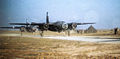
 323d Bombardment Group - B-26 Marauder 41-31643.jpg 1,310 × 862; 998 KB
-
 323d Bombardment Group - B-26 Marauder 41-31944.jpg 944 × 1,137; 202 KB
-
 323d Bombardment Group - B-26 Marauder 41-34705.jpg 1,314 × 896; 150 KB
-
 323d Bombardment Group - B-26 Marauder 41-34854.jpg 1,290 × 861; 182 KB
-
 323d Bombardment Group - B-26 Marauder 41-34863.jpg 1,297 × 859; 167 KB
-
 323d Bombardment Group - B-26 Marauder 41-34879.jpg 1,309 × 864; 158 KB
-
 323d Bombardment Group - B-26 Marauder Makahlea II.jpg 1,392 × 955; 277 KB
-
 323d Bombardment Group - B-26 Marauder taking off 2.jpg 1,316 × 968; 123 KB
-
 323d Bombardment Group - B-26 Marauder taking off.jpg 1,416 × 909; 117 KB
-
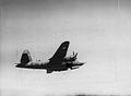
 94th Bombardment Group B-17F In Flight.jpg 1,381 × 885; 165 KB
-
 Aircraft at Earls Colne Airfield - geograph.org.uk - 5863755.jpg 4,608 × 3,456; 3.97 MB
-
 Aircraft at Earls Colne Airfield - geograph.org.uk - 5864267.jpg 4,608 × 3,456; 3.89 MB
-
 Airfield Buildings at Earls Colne Airfield - geograph.org.uk - 5863768.jpg 3,842 × 2,881; 3.26 MB
-
 Airfield Buildings at Earls Colne Airfield - geograph.org.uk - 5864477.jpg 4,608 × 3,456; 3.94 MB
-
 Airfield Buildings at Earls Colne Airfield - geograph.org.uk - 5864488.jpg 4,608 × 3,456; 3.96 MB
-
 Airfield Buildings at Earls Colne Airfield - geograph.org.uk - 5865371.jpg 4,608 × 3,456; 3.81 MB
-
 Allotments near Earls Colne Airfield - geograph.org.uk - 4507414.jpg 3,648 × 2,432; 2.68 MB
-
 Earls Colne Airfield - geograph.org.uk - 149989.jpg 640 × 480; 69 KB
-
 Earls Colne Airfield - geograph.org.uk - 2134061.jpg 1,024 × 683; 191 KB
-
 G-ACUS (32884538712).jpg 1,200 × 800; 1.02 MB
-
 G-AZOZ (32884536382).jpg 1,200 × 800; 1.01 MB
-
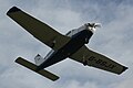 G-BSJX Piper PA-28-161 Warrior II @ Earls Colne 16022017.jpg 1,200 × 800; 521 KB
-
 G-ECAC on final approach - geograph.org.uk - 4112696.jpg 3,072 × 2,304; 382 KB
-
 G-ECAK (32998717956).jpg 1,200 × 800; 992 KB
-
 G-EHAA (32884524082).jpg 1,200 × 800; 983 KB
-
 Lancaster Way - geograph.org.uk - 149994.jpg 640 × 480; 85 KB
-
 Makeshift Navigation Markers - geograph.org.uk - 150002.jpg 640 × 480; 90 KB
-


.jpg)


.jpg)
.jpg)


.jpg)
.jpg)


.jpg)