Category:Dutch Suratte
Jump to navigation
Jump to search
colonial trading company  | |||||
| Upload media | |||||
| Instance of | |||||
|---|---|---|---|---|---|
| Inception |
| ||||
| Dissolved, abolished or demolished date |
| ||||
| |||||
Subcategories
This category has the following 2 subcategories, out of 2 total.
D
Media in category "Dutch Suratte"
The following 38 files are in this category, out of 38 total.
-
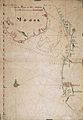 AMH-2557-NA Map of the coast of Dekan and Canare.jpg 1,655 × 2,400; 631 KB
-
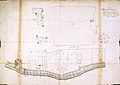
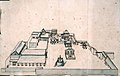
 AMH-2574-NA Map of the lodge and houses in the city of Souratte.jpg 2,400 × 1,705; 522 KB
-
-
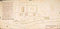
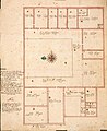
 AMH-2576-NA Floor plan of the new lodge at Soeratte.jpg 2,400 × 1,864; 576 KB
-
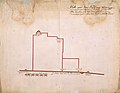
 AMH-2577-NA Map of a piece of land in Suratte.jpg 2,400 × 1,158; 316 KB
-
 AMH-2578-NA Floor plan for the new lodge to be built at Brotchia.jpg 2,400 × 1,945; 532 KB
-
 AMH-2579-NA Map of the residence and warehouses of the company in Amadabat.jpg 2,400 × 1,750; 676 KB
-
 AMH-2625-NA Representation of the lodge at Amadabat.jpg 2,400 × 1,517; 608 KB
-
 AMH-2626-NA Ground plan of the new lodge to be built at Brotchia.jpg 2,059 × 2,400; 800 KB
-
 AMH-2627-NA Floor plan of the new lodge to be built at Brotchia.jpg 1,965 × 2,400; 767 KB
-
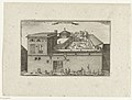
 AMH-2628-NA Representation of the lodge of the Company at Agra.jpg 2,400 × 1,821; 516 KB
-
 AMH-2629-NA Floor plan of the lodge of the Company at Agra.jpg 2,400 × 1,746; 613 KB
-
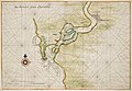
 AMH-5117-NA Map of Souratte and Souratte river.jpg 2,400 × 1,726; 578 KB
-
 AMH-5344-NA Map showing the cities between Souratta and Amed Abaad.jpg 1,745 × 2,400; 470 KB
-
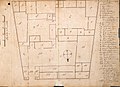
 AMH-5345-NA Floor plan of the Dutch lodge at Souratte.jpg 1,683 × 2,400; 404 KB
-
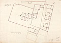 AMH-5346-NA Floor plan of the Dutch lodge at Souratte.jpg 2,400 × 1,709; 393 KB
-
 AMH-5347-NA Floor plan of the Dutch lodge at Souratte.jpg 2,400 × 1,709; 397 KB
-
 AMH-5348-NA Floor plan of the Dutch lodge at Souratte.jpg 2,400 × 1,706; 415 KB
-
 AMH-5349-NA Floor plan of the 'tent' at Soualys beach.jpg 2,400 × 1,754; 376 KB
-
 AMH-5604-NA Map of the river of Suratte.jpg 2,400 × 1,707; 696 KB
-
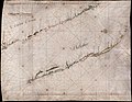
 AMH-5605-NA Map of the coasts of Decan and Malabar, from Suratte to Cape Comorin.jpg 1,921 × 2,400; 754 KB
-
 AMH-5606-NA Map of the coast of Malabar, from Suratte to Cape Comorin.jpg 2,400 × 1,855; 840 KB
-
 AMH-6164-NA View of Visiapour (according to the title), depicted is Suratte.jpg 2,400 × 1,802; 474 KB
-
 AMH-6438-NA Map showing the cities between Souratte and Ahmadabad.jpg 1,680 × 2,400; 408 KB
-
 AMH-6737-NA Map of the Suratte river.jpg 2,400 × 1,657; 735 KB
-
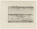
 AMH-6840-KB View of Suratte.jpg 2,400 × 1,821; 1.16 MB
-
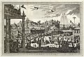 AMH-6899-KB The cour of the great mogul at Agra.jpg 2,400 × 1,646; 1.19 MB
-
 Brotsch int ryck vanden Grooten Mogol en Indien - Peeters Jacob - 1690.jpg 1,500 × 838; 816 KB
-
 De Hollandse loge op Surat, 1629 Logie van Suratte (titel op object), RP-P-OB-75.465.jpg 6,052 × 4,568; 5.57 MB
-
 Dutch East India Company's warehouse and living quarters in Surat.jpg 2,095 × 1,419; 640 KB
-
 Gezicht op de haven van Suratte (Gujarat) Rijksmuseum SK-A-4778.jpeg 2,944 × 1,980; 2.52 MB
-

-
-

-
 Madril Mexico Svratte Moscua Batavia Ormus (titel op object), NG-20-A.jpg 4,020 × 4,810; 3.69 MB
-
 Ormovs Svrattte Bantam Damasco Batavia Iervsalem Goa Calecvth (titel op object), NG-20-C.jpg 4,052 × 4,834; 3.91 MB
-
 Sourratte int ryck vanden Grooten Mogol en Indien - Peeters Jacob - 1690.jpg 1,500 × 825; 844 KB
-


,_depicted_is_Suratte.jpg)


,_RP-P-OB-75.465.jpg)
_Rijksmuseum_SK-A-4778.jpeg)
_Gezichten_in_India_uit_de_jaren_1678-1679_(serietitel),_RP-T-1969-2.jpg)
_De_vermaerde_Stadt_Suratte,_RP-P-OB-75.466.jpg)
_Les_Forces_de_l%27Europe,_Asie,_Afrique_et_Amerique_Comme_aussi_les_Cartes_des_C%C3%B4tes_de_France_et_d%27Espagne_(serietitel_op_object),_RP-P-OB-83.036-237.jpg)
,_NG-20-A.jpg)
,_NG-20-C.jpg)

.jpg)