Category:Durrington, West Sussex
Jump to navigation
Jump to search
English: Durrington is a neighbourhood of the Borough of Worthing in West Sussex, England. It is situated near the A27 road, 2.3 miles (3.8 km) northwest of the town centre.
suburb of Worthing, West Sussex, United Kingdom  | |||||
| Upload media | |||||
| Instance of | |||||
|---|---|---|---|---|---|
| Location | Worthing, West Sussex, South East England, England | ||||
 | |||||
Subcategories
This category has the following 5 subcategories, out of 5 total.
D
- Durrington Cemetery (4 F)
N
- New Life Church, Durrington (8 F)
Media in category "Durrington, West Sussex"
The following 28 files are in this category, out of 28 total.
-
 Blocked footpath, West Durrington - geograph.org.uk - 1736456.jpg 640 × 428; 165 KB
-
 Canberra Road, West Durrington - geograph.org.uk - 1736447.jpg 640 × 428; 135 KB
-

-
 Centenary House, Durrington (Geograph Image 019179 b9627b87).jpg 640 × 480; 48 KB
-
 Clothes and shoes - geograph.org.uk - 1736465.jpg 640 × 428; 116 KB
-
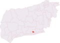 Durrington & Salvington (electoral division).png 472 × 340; 24 KB
-
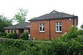
 Durrington Community Centre - geograph.org.uk - 616923.jpg 640 × 480; 79 KB
-
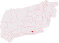 Durrington salvington (electoral division).svg 476 × 343; 162 KB
-
 Goring Business Park - geograph.org.uk - 1726709.jpg 640 × 428; 97 KB
-
 Hawthorns First School - geograph.org.uk - 1163651.jpg 640 × 480; 106 KB
-
 Laurels First School - geograph.org.uk - 1163673.jpg 640 × 480; 77 KB
-
 Mitchell's Furzefield - geograph.org.uk - 1333884.jpg 480 × 640; 160 KB
-
 Orchards Middle School - geograph.org.uk - 1163631.jpg 640 × 480; 51 KB
-
 Site of former St Michael's Church, Cotswold Drive, Durrington (May 2013).JPG 2,400 × 1,800; 892 KB
-
 South Lodge, Titnore Lane - geograph.org.uk - 1333880.jpg 480 × 640; 71 KB
-
 St Symphorian's Church Hall, Durrington Hill, Durrington (May 2013).JPG 2,400 × 1,600; 779 KB
-
 Sweet chariot - geograph.org.uk - 1096584.jpg 640 × 480; 92 KB
-
 The Farmhouse, Fulbeck Avenue, Worthing - geograph.org.uk - 597148.jpg 640 × 480; 109 KB
-
 The Lamb Inn, Salvington Road - geograph.org.uk - 778423.jpg 640 × 480; 71 KB
-

-
 Titnore Lane - geograph.org.uk - 1333911.jpg 640 × 480; 58 KB
-
 Titnore Way - geograph.org.uk - 1333892.jpg 480 × 640; 83 KB
-
 Bridleway at No Man's Land - geograph.org.uk - 1416386.jpg 640 × 480; 132 KB
-
 Cissbury Lodge, Durrington Lane - geograph.org.uk - 657095.jpg 640 × 480; 66 KB
-

-

-
 Honeysuckle Lane - geograph.org.uk - 1416405.jpg 640 × 480; 149 KB
-
 Site for new Tesco - geograph.org.uk - 612315.jpg 640 × 480; 53 KB


.jpg)

.png)
.svg)


.JPG)

.JPG)


