Category:Duns Tew
Jump to navigation
Jump to search
village and civil parish in Cherwell district, Oxfordshire, England  | |||||
| Upload media | |||||
| Instance of | |||||
|---|---|---|---|---|---|
| Location | Cherwell, Oxfordshire, South East England, England | ||||
| Population |
| ||||
| Area |
| ||||
| Said to be the same as | Duns Tew (Wikimedia duplicated page, civil parish) | ||||
| official website | |||||
 | |||||
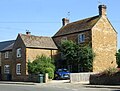
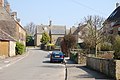
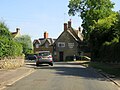
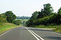
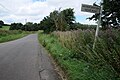
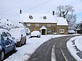
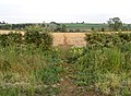
English: Duns Tew is a village and civil parish about south of Banbury. With nearby Great Tew and Little Tew, Duns Tew is one of the three villages known locally as the "The Tews".
Media in category "Duns Tew"
The following 35 files are in this category, out of 35 total.
-
 A house on Main Street - geograph.org.uk - 5865865.jpg 2,700 × 2,054; 547 KB
-
 A4260 northwest of Dane Hill Farm - geograph.org.uk - 3400042.jpg 3,648 × 2,736; 1.38 MB
-
 A4260 south of Dedington - geograph.org.uk - 2689365.jpg 3,648 × 2,527; 1.26 MB
-
 Concrete mixer near Duns Tew - geograph.org.uk - 1879429.jpg 3,648 × 2,736; 2.21 MB
-
 White Horse Inn Public House - geograph.org.uk - 386104.jpg 640 × 425; 208 KB
-
 Duns Tew - general view - geograph.org.uk - 386111.jpg 640 × 425; 186 KB
-
 Duns Tew village hall, 6th April 2008 - geograph.org.uk - 949511.jpg 640 × 480; 102 KB
-
 Duns Tew village1.jpg 640 × 480; 129 KB
-
 Duns Tew-The White Horse Inn - geograph.org.uk - 6194140.jpg 1,600 × 1,200; 625 KB
-
 Farm building and field - geograph.org.uk - 385645.jpg 640 × 425; 178 KB
-
 Houses at Dane Hill along Oxford Road - geograph.org.uk - 4523498.jpg 1,024 × 710; 165 KB
-
 Main Street in Duns Tew - geograph.org.uk - 5865853.jpg 2,700 × 2,025; 417 KB
-
 Main Street in Duns Tew - geograph.org.uk - 5865856.jpg 2,700 × 1,945; 460 KB
-
 Main Street in Duns Tew - geograph.org.uk - 5865861.jpg 2,700 × 2,025; 448 KB
-
 Mixed farming - geograph.org.uk - 1879422.jpg 3,648 × 2,736; 2.05 MB
-
 Oxford Road on Dane Hill - geograph.org.uk - 4057855.jpg 1,500 × 999; 133 KB
-
 Oxford Road to Deddington - geograph.org.uk - 4057856.jpg 1,500 × 999; 114 KB
-
 Re Cycling point for Duns Tew - geograph.org.uk - 1879409.jpg 3,648 × 2,736; 2.16 MB
-
 Road junction near Ilbury Bridge - geograph.org.uk - 5061703.jpg 1,024 × 680; 306 KB
-
 Road junction west of Duns Tew - geograph.org.uk - 1748211.jpg 640 × 480; 71 KB
-
 Road to Nether Worton - geograph.org.uk - 5061706.jpg 1,024 × 680; 269 KB
-
 Rural road to Duns Tew - geograph.org.uk - 5865852.jpg 2,700 × 2,025; 543 KB
-
 Village street scene - geograph.org.uk - 1879405.jpg 3,648 × 2,736; 2.26 MB
-
-
 Across the fields to Hill Farm - geograph.org.uk - 463894.jpg 640 × 480; 107 KB
-
 Bridleway bridge - geograph.org.uk - 452222.jpg 640 × 480; 157 KB
-
 Bridleway passes through hedge - geograph.org.uk - 452262.jpg 640 × 467; 116 KB
-
 Bridleways split - geograph.org.uk - 452255.jpg 640 × 493; 112 KB
-
 Feeding time near Duns Tew - geograph.org.uk - 386119.jpg 640 × 425; 184 KB
-
 Field opposite "Greenacres" - geograph.org.uk - 385640.jpg 640 × 425; 165 KB
-
 Field south of Duns Tew - geograph.org.uk - 385630.jpg 640 × 425; 179 KB
-
 Hill Farm, from Plumdon Lane - geograph.org.uk - 452126.jpg 640 × 383; 78 KB
-
 Lower Farm near Duns Tew - geograph.org.uk - 385620.jpg 640 × 425; 192 KB
-
 Seagrave's Covert - geograph.org.uk - 452213.jpg 640 × 480; 101 KB
-
 Very muddy bridge - geograph.org.uk - 452225.jpg 480 × 640; 120 KB


