Category:Dr. Knisley Covered Bridge
Jump to navigation
Jump to search
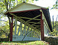
English: Dr. Knisley Covered Bridge built in 1867 over Dunning Creek in at West St. Clair Township, Bedford County, Pennsylvania, USA.
|
This is a category about a place or building that is listed on the National Register of Historic Places in the United States of America. Its reference number is 80003411. |
| Object location | | View all coordinates using: OpenStreetMap |
|---|
 | |||||
| Upload media | |||||
| Instance of | |||||
|---|---|---|---|---|---|
| Location | Pennsylvania | ||||
| Crosses |
| ||||
| Heritage designation |
| ||||
 | |||||
Media in category "Dr. Knisley Covered Bridge"
The following 2 files are in this category, out of 2 total.
-
 Dr Knisley Covered Bridge 1.jpg 3,648 × 2,736; 4.16 MB
-
 Dr Knisley Covered Bridge 2.jpg 3,183 × 2,493; 2.34 MB

Categories:
- National Register of Historic Places in Bedford County, Pennsylvania
- Covered bridges in Pennsylvania
- Bridges on the National Register of Historic Places in Pennsylvania
- Bridges in Bedford County, Pennsylvania
- Burr truss
- Covered bridges on the National Register of Historic Places in Pennsylvania
- West St. Clair Township, Bedford County, Pennsylvania