Category:Dorfkirche Wilschdorf
Jump to navigation
Jump to search
| Object location | | View all coordinates using: OpenStreetMap |
|---|
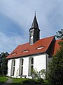
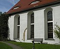
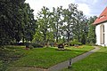
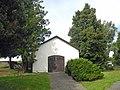
church building in Dürrröhrsdorf-Dittersbach, Saxony, Germany _Kirche.jpg) _Kirche.jpg) | |||||
| Upload media | |||||
| Instance of | |||||
|---|---|---|---|---|---|
| Location | Wilschdorf, Dürrröhrsdorf-Dittersbach, Sächsische Schweiz-Osterzgebirge, Saxony, Germany | ||||
| Street address |
| ||||
| Heritage designation | |||||
| Inception |
| ||||
 | |||||
| (Wikidata) |
Deutsch: Dorfkirche und Kirchhof in Wilschdorf bei Dürrröhrsdorf-Dittersbach, errichtet 1678.
Subcategories
This category has only the following subcategory.
Media in category "Dorfkirche Wilschdorf"
The following 15 files are in this category, out of 15 total.
-
 20181018100DR Wilschdorf (Dürrröhrsdorf-Dittersbach) Kirche.jpg 3,376 × 2,507; 5.59 MB
-
 20181018105DR Wilschdorf (Dürrröhrsdorf-Dittersbach) Kirche.jpg 3,202 × 2,611; 6.29 MB
-
 20181018110DR Wilschdorf (Dürrröhrsdorf-Dittersbach) Kirche.jpg 3,127 × 2,748; 4.64 MB
-
 20181018185DR Wilschdorf (Dürrröhrsdorf-Dittersbach) Kirche Glocke.jpg 3,143 × 2,477; 5.87 MB
-
 Wilschdorf-KD.jpg 1,968 × 2,701; 2.02 MB
-
 Wilschdorf-Kirche-1.jpg 3,834 × 3,280; 3.96 MB
-
 Wilschdorf-Kirche-2.jpg 2,290 × 3,053; 2.44 MB
-
 Wilschdorf-Kirche-3.jpg 3,447 × 3,289; 3.15 MB
-
 Wilschdorf-Kirche-4.jpg 3,288 × 2,693; 2.05 MB
-
 Wilschdorf-Kirchhof-1.jpg 3,340 × 2,227; 2.16 MB
-
 Wilschdorf-Kirchhof-2.jpg 3,240 × 2,430; 2.07 MB
-
 Wilschdorf-Kirchhof-3.jpg 3,648 × 2,520; 2.69 MB
-
 Wilschdorf-Kirchhof-4.jpg 2,736 × 3,648; 2.16 MB
-
 Wilschdorf-Kirchhof-5.jpg 2,036 × 3,054; 1.69 MB
-
 Wilschdorf-Kirchhof-6.jpg 3,202 × 2,402; 1.99 MB
_Kirche.jpg)
_Kirche.jpg)
_Kirche_Glocke.jpg)


