Category:Dorfkirche Rudow
Jump to navigation
Jump to search
| Object location | | View all coordinates using: OpenStreetMap |
|---|
church   | |||||
| Upload media | |||||
| Instance of | |||||
|---|---|---|---|---|---|
| Made from material | |||||
| Location | Neukölln, Berlin, Germany | ||||
| Heritage designation | |||||
 | |||||
This is the category of the Berliner Kulturdenkmal (cultural monument) with the ID 09090319 (Wikidata)
|
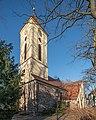
Deutsch: Die Dorfkirche Rudow in Berlin-Rudow dient einer Gemeinde der unierten Evangelischen Kirche Berlin-Brandenburg-Schlesische Oberlausitz.
English: The village church of Rudow, Berlin, Germany, serves a congregation within the Evangelical Church of Berlin-Brandenburg-Silesian Upper Lusatia, a united Protestant church body of Calvinist, Lutheran and united congregations.
Media in category "Dorfkirche Rudow"
The following 13 files are in this category, out of 13 total.
-
 Berlin Rudow EvKirche asv2021-03 img1.jpg 3,855 × 4,819; 13.11 MB
-
 Berlin Rudow EvKirche asv2021-03 img2.jpg 3,810 × 4,762; 9.85 MB
-
 Berlin-Rudow, Dorfkirche, Orgel (1).jpg 1,536 × 2,048; 894 KB
-
 Dorfkirche Rudow 02.jpg 800 × 533; 416 KB
-
 Dorfkirche Rudow Altar.jpg 6,016 × 4,000; 17.53 MB
-
 Dorfkirche Rudow Auferstehungsfenster.jpg 6,016 × 4,000; 11.97 MB
-
 Dorfkirche Rudow Orgel.jpg 6,016 × 4,000; 17.1 MB
-
 Dorfkirche Rudow Pieta.jpg 6,016 × 4,000; 15.63 MB
-
 Dorfkirche Rudow Taufbecken.jpg 6,016 × 4,000; 16.99 MB
-
 Dorfkirche Rudow.jpg 2,816 × 2,112; 1,018 KB
-
 Dorfkirche, Berlin-Rudow, Altar.jpg 3,542 × 2,437; 1.39 MB
-
 Dorfkirche, Berlin-Rudow, Kanzel.jpg 3,153 × 2,464; 1.27 MB
-
 Rudow Dorfkirche.jpg 1,200 × 1,600; 1.07 MB

.jpg)


