Category:Dorfkirche Prötzel
Jump to navigation
Jump to search
| Object location | | View all coordinates using: OpenStreetMap |
|---|
church building in Brandenburg state, Germany  | |||||
| Upload media | |||||
| Instance of | |||||
|---|---|---|---|---|---|
| Location | Prötzel, Märkisch-Oderland District, Brandenburg, Germany | ||||
| Heritage designation | |||||
 | |||||
This is the category of the Brandenburger Baudenkmal (cultural heritage monument) with the ID 09180617 (Wikidata)
|
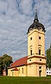
Deutsch: Bilder der Kirche in Prötzel, Gemeinde Prötzel, Landkreis Märkisch-Oderland, Land Brandenburg, Deutschland.
English: Pictures of the church in Prötzel, Prötzel municipality, Märkisch-Oderland district, Brandenburg state, Germany
Français : Photos de l'église à Prötzel, commune de Prötzel, arrondissement de Märkisch-Oderland, état fédéral de Brandebourg, Allemagne
Media in category "Dorfkirche Prötzel"
The following 7 files are in this category, out of 7 total.
-
 18-05-03-Prötzel RRK2095-2100.jpg 5,869 × 4,382; 12.22 MB
-
 18-05-03-Prötzel RRK2103.jpg 2,098 × 3,147; 4.16 MB
-
 18-05-03-Prötzel RRK2104.jpg 2,315 × 3,800; 5.48 MB
-
 Prötzel - Kirche - 2.jpg 3,306 × 2,803; 4.97 MB
-
 Prötzel church, Germany - panoramio (1).jpg 3,072 × 1,728; 1.12 MB
-
 Prötzel church, Germany - panoramio.jpg 3,072 × 1,728; 1.22 MB
-
 Prötzel, Kirche.jpg 1,187 × 1,725; 936 KB


.jpg)

