Category:Dorfkirche Mahlow
Jump to navigation
Jump to search
| Object location | | View all coordinates using: OpenStreetMap |
|---|
  | |||||
| Upload media | |||||
| Instance of | |||||
|---|---|---|---|---|---|
| Location | Mahlow, Blankenfelde-Mahlow, Teltow-Fläming District, Brandenburg, Germany | ||||
| Heritage designation | |||||
 | |||||
This is the category of the Brandenburger Baudenkmal (cultural heritage monument) with the ID 09105437 (Wikidata)
|
Subcategories
This category has only the following subcategory.
Media in category "Dorfkirche Mahlow"
The following 16 files are in this category, out of 16 total.
-
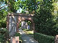 Dorfkirche Mahlow Einfriedung mit Portal.jpg 4,032 × 3,024; 5.04 MB
-
 Dorfkirche Mahlow Kirchenschiff Nordseite.jpg 4,032 × 3,024; 3.9 MB
-
 Dorfkirche Mahlow Ostansicht.jpg 4,032 × 3,024; 3.39 MB
-
 Dorfkirche Mahlow Südostansicht.jpg 4,032 × 3,024; 3.88 MB
-
 Dorfkirche Mahlow Westportal.jpg 4,032 × 3,024; 4.21 MB
-
 Dorfkirche Mahlow Westturm Nordwestansicht.jpg 3,024 × 4,032; 1.96 MB
-
 Dorfkirche Mahlow Westturm Sockel Südwestansicht.jpg 4,032 × 3,024; 4.23 MB
-
 Dorfkirche Mahlow Westturm Südwestansicht.jpg 3,024 × 4,032; 4.18 MB
-
 Kirche Mahlow 2018 01.jpg 6,016 × 4,000; 12.46 MB
-
 Kirche Mahlow 2018 02.jpg 6,016 × 4,000; 14.15 MB
-
 Kirche Mahlow 2018 03.jpg 6,016 × 4,000; 13.47 MB
-
 Kirche Mahlow 2018 04.jpg 6,016 × 4,000; 12.72 MB
-
 Kirche Mahlow 2018 05.jpg 6,016 × 4,000; 16.21 MB
-
 Kirche Mahlow 2018 06.jpg 6,016 × 4,000; 14.33 MB
-
 Kirche Mahlow Blankenfelde-Mahlow.jpg 3,872 × 2,592; 1.93 MB
-
 Mahlow church.jpg 2,190 × 3,000; 1.33 MB


