Category:Dorfkirche Lindenberg (Ahrensfelde)
Jump to navigation
Jump to search
| Object location | | View all coordinates using: OpenStreetMap |
|---|
church building in Brandenburg state, Germany  | |||||
| Upload media | |||||
| Instance of | |||||
|---|---|---|---|---|---|
| Location | Ahrensfelde, Barnim District, Brandenburg, Germany | ||||
| Heritage designation | |||||
 | |||||
This is the category of the Brandenburger Baudenkmal (cultural heritage monument) with the ID 09175370 (Wikidata)
|
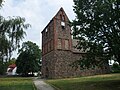
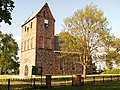
Deutsch: Die Dorfkirche von Lindenberg, Gemeinde Ahrensfelde, Landkreis Barnim, Land Brandenburg, Deutschland. Granitquaderbau aus dem 13. Jahrhundert. Der Feldsteinbau gehört zu den ältesten erhaltenen Kirchen in Brandenburg.
English: The village church of Lindenberg, Ahrensfelde municipality,, Barnim district, Brandenburg state, Germany. This 13th century church belongs to the oldest ones in Brandenburg.
Media in category "Dorfkirche Lindenberg (Ahrensfelde)"
The following 21 files are in this category, out of 21 total.
-
 Dorfkirche Lindenberg.jpg 4,000 × 3,000; 6.4 MB
-
 Dorfteich in Lindenberg (Ahrensfelde).jpg 4,000 × 3,000; 7.02 MB
-
 Dorfteich Lindenberg.jpg 4,000 × 3,000; 5.82 MB
-
 Lindenberg Barnim Alte Schulstraße 0016.JPG 2,848 × 2,136; 2.04 MB
-
 Lindenberg Barnim church 0001.JPG 2,848 × 2,136; 2.24 MB
-
 Lindenberg Barnim church 0004.JPG 2,848 × 2,136; 1.6 MB
-
 Lindenberg Barnim church 0006.JPG 2,848 × 2,136; 2.44 MB
-
 Lindenberg Barnim church 0007.JPG 2,848 × 2,136; 2.52 MB
-
 Lindenberg Barnim church 0008.JPG 2,136 × 2,848; 2.16 MB
-
 Lindenberg Barnim church 0009.JPG 2,136 × 2,848; 1.62 MB
-
 Lindenberg Barnim church 0010.JPG 2,848 × 2,136; 2.81 MB
-
 Lindenberg Barnim church 0011.jpg 2,848 × 2,136; 1.98 MB
-
 Lindenberg Barnim church 0012.JPG 2,848 × 2,136; 2.71 MB
-
 Lindenberg Barnim church 0013.JPG 2,848 × 2,136; 2.66 MB
-
 Lindenberg Barnim church 0015.JPG 2,848 × 2,136; 2.55 MB
-
 Lindenberg Barnim church 0017.JPG 2,848 × 2,136; 2.56 MB
-
 Lindenberg Barnim church 0030.JPG 2,848 × 2,136; 2.23 MB
-
 Lindenberg Barnim Wartenberger Straße church0029.jpg 2,848 × 2,136; 1.79 MB
-
 Lindenberg Dorfkirche.jpg 4,000 × 3,000; 6.27 MB
-
 Lindenberg Kirche.jpg 2,560 × 1,920; 1.24 MB
-
 Lindenberger Dorfkirche.jpg 4,000 × 3,000; 5.7 MB

.jpg)


